
| During the month of April, Mark Miller will donate $75 to the charity of your choice (5 to chose from, including the Utah Avalanche Center!) Mark Miller Subaru has raised over $300k in the previous 6 Do Good Feel Good events. More Info here |  |
| During the month of April, Mark Miller will donate $75 to the charity of your choice (5 to chose from, including the Utah Avalanche Center!) Mark Miller Subaru has raised over $300k in the previous 6 Do Good Feel Good events. More Info here | |
| Advisory: Logan Area Mountains | Issued by Toby Weed for Tuesday - February 3, 2015 - 6:14am |
|---|

|
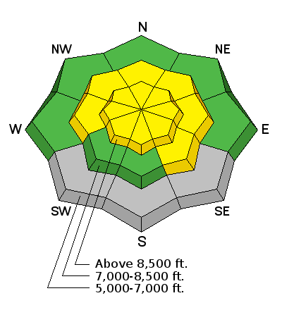
bottom line Heightened avalanche conditions exist and there's a MODERATE (level 2) danger in the backcountry today. Wind slab avalanches are possible in drifted terrain and storm snow avalanches will become more likely as more snow piles up. Accumulating snow and strong west winds will cause a rising avalanche danger today, overnight, and tomorrow.
|
 |
special announcement Sign up now for Avalanche Awareness for Snowmobilers with the UAC in Logan, February 5th evening and a field session on Saturday the 7th. ***Check out our Practicing Companion Rescue video........HERE
|
 |
current conditions The Tony Grove Snotel reports 5 inches of heavy new snow in the last 24 hours, containing 1.2" of water. There's now 66 inches of total snow containing 107% of average water for the date and it's 32 degrees at the 8400' site. The UDOT Hwy 89 Logan Summit weather station reports 33 degrees this morning and sustained west winds overnight, averaging around 20 mph with gusts around 30 mph.
A view of upper Smithfield Canyon in the Mt. Naomi Wilderness, 1-29-15 *** New, 2-2-15 Video Observation from South Tony Grove..........HERE
|
 |
recent activity No new avalanches were reported recently in the Logan Zone. Visit our Backcountry Observations Page for more local information and from across the state.
|
| type | aspect/elevation | characteristics |
|---|

|
|
LIKELIHOOD
 LIKELY
UNLIKELY
SIZE
 LARGE
SMALL
TREND
 INCREASING DANGER
SAME
DECREASING DANGER
|
|
description
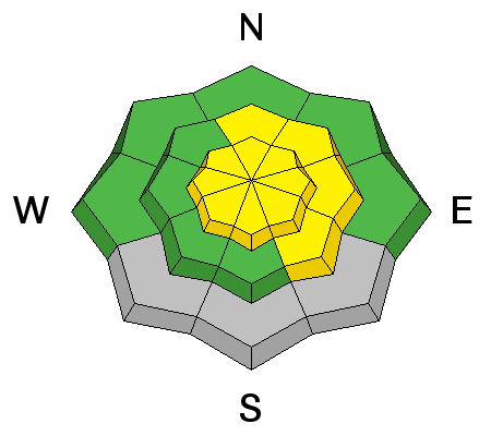
Heightened conditions exist in drifted terrain at upper elevations where triggered wind slab avalanches are possible, and sustained west winds will continue through the day and increase tonight. You should be wary around terrain features like cliff bands, sub-ridges, and gullies where wind slabs may have formed, and avoid steep drifted slopes. The danger of wind slab avalanches will increase with accumulation and continued windy conditions today, tonight, and tomorrow.
|
| type | aspect/elevation | characteristics |
|---|

|
|
LIKELIHOOD
LIKELY
UNLIKELY
SIZE
LARGE
SMALL
TREND
INCREASING DANGER
SAME
DECREASING DANGER
|
|
description
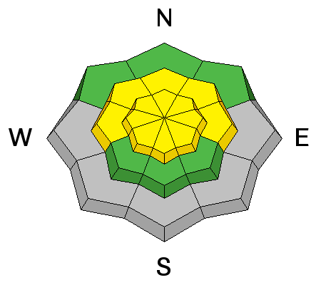
The rain/snow line is still fairly high, but heavy snow is starting to stack up above about 7500'. I noticed a poor bond of the new snow and the much warmer melt-freeze crust that was on the snow surface early last week. There appears to be weak snow right on top of the crust in some areas. As heavy snow continues to pile up today soft slab avalanches involving the storm snow will become more likely.
|
 |
weather Snow is likely today, with 2 to 4 inches of additional accumulation possible.. It will be fairly windy at upper elevations, with west winds gusting into the 30 mph range and high temperature at 8500' of around 38 degrees. Snow is likely tonight in the mountains, with 5 to 9 inches of accumulation possible, along with increasingly strong west wind and temperatures around 34 degrees. Snow will continue at upper elevations under a mild moist zonal flow through tomorrow. Check out our one-stop weather page........HERE
|
| general announcements Special thanks to Buttar's and ArcticCat for hooking us up with the light and powerful M8000. This machine will make our field days more fun, safe, and productive and will significantly boost our outreach and education efforts. RESEARCH PROJECT ON UNDERSTANDING TRAVEL BEHAVIOR IN AVALANCHE TERRAIN NEEDS YOU!! Scientists from the Snow and Avalanche Lab at Montana State University are seeking more participants for their project examining decision making and travel in avalanche terrain. Their project aims to collect GPS location information (from your smartphone) and survey responses from backcountry skiers and riders to better understand what types of terrain are used, and how decisions are made. Their focus is on backcountry skiers and riders of all abilities and experience. More information: If you want to participate, or learn more about their project aims, research questions and approaches, please visit their web page: www.montana.edu/snowscience/tracks or their companion site directed toward snowmobilers at: www.montana.edu/snowscience/sleds You can now receive advisories by email for the Logan Zone. Go here for details. Get your advisory on your iPhone along with great navigation and rescue tools, with our updated, Utah Avalanche Center mobile app Discount lift tickets are now available at Backcountry.com. Thanks to Ski Utah and the Utah Resorts. All proceeds go towards paying for Utah Avalanche Center avalanche and mountain weather advisories. Benefit the Utah Avalanche Center when you shop from Backcountry.com or REI: Click this link for Backcountry.com or this link to REI, shop, and they will donate a percent of your purchase price to the UAC. Both offer free shipping (with some conditions) so this costs you nothing! Benefit the Utah Avalanche Center when you buy or sell on ebay - set the Utah Avalanche Center as a favorite non-profit in your ebay account here and click on ebay gives when you buy or sell. You can choose to have your seller fees donated to the UAC, which doesn't cost you a penny. ***Please submit snow and avalanche observations from your ventures in the backcountry HERE. You can call us at 801-524-5304 or email HERE, or include #utavy in your Instagram or Tweet us @UAClogan. To report avalanche activity in the Logan Area or to contact the local avalanche forecaster call me, Toby, at 435-757-7578. I'll regularly update this advisory on Monday, Wednesday, Friday, and Saturday mornings by about 7:30. This advisory is produced by the U.S.D.A. Forest Service, which is solely responsible for its content. It describes only general avalanche conditions and local variations always exist. |


_1.jpg)

