| During the month of April, Mark Miller will donate $75 to the charity of your choice (5 to chose from, including the Utah Avalanche Center!) Mark Miller Subaru has raised over $300k in the previous 6 Do Good Feel Good events. More Info here |  |
| During the month of April, Mark Miller will donate $75 to the charity of your choice (5 to chose from, including the Utah Avalanche Center!) Mark Miller Subaru has raised over $300k in the previous 6 Do Good Feel Good events. More Info here | |
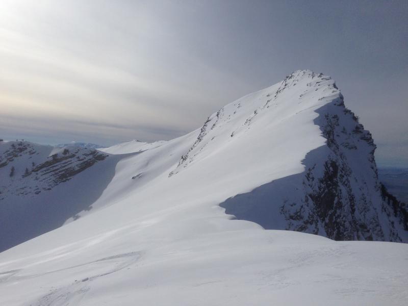
| Advisory: Logan Area Mountains | Issued by Toby Weed for Saturday - January 31, 2015 - 6:49am |
|---|

|
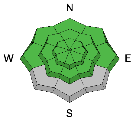
bottom line The snow is stable on most slopes and the overall danger is LOW (level 1) in the backcountry. Pockets with heightened avalanche conditions may remain on some drifted steep upper elevation slopes, where small triggered wind slab avalanches are possible.
|
 |
special announcement Sign up now for Avalanche Awareness for Snowmobilers with the UAC in Logan, February 5th evening and a field session on Saturday the 7th. Special thanks to Buttar's and ArcticCat for hooking us up with the light and powerful M8000. This machine will make our field days more fun, safe, and productive and will significantly boost our outreach and education efforts. ***Check out our Practicing Companion Rescue video........HERE
|
 |
current conditions A few inches at upper elevations during the week freshened up the view and helped riding conditions, but wasn't enough to change avalanche conditions much. You'll find stable snow on most slopes and avalanches are generally unlikely in the Logan Zone this weekend. With an inch of new snow overnight, it's 28 degrees, and there's 60 inches of total snow at the 8400' Tony Grove Snotel, currently containing 103% of average water for the date. The UDOT hwy 89 Logan Summit weather station reports 24 degrees this morning and light east winds overnight. A few inches of new snow this week freshened up the view and did wonders for the riding conditions. Cherry Peak (1-29-15) ***1-29-15 Observation from Cherry Peak and the Mt. Naomi Wilderness...........HERE
|
 |
recent activity No new avalanches were reported recently in the Logan Zone, but we noticed visible evidence of some small natural activity in the Mt. Naomi Wilderness. Visit our Backcountry Observations Page for more local information and from across the state.
|
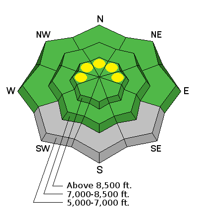
| type | aspect/elevation | characteristics |
|---|

|
|
LIKELIHOOD
 LIKELY
UNLIKELY
SIZE
 LARGE
SMALL
TREND
 INCREASING DANGER
SAME
DECREASING DANGER
|
|
description
Pockets of heightened conditions may linger in drifted terrain at upper elevations where triggered wind slab avalanches are unlikely yet possible. Stiff wind slabs consisting of Wednesday's snow will be stubborn, but they also might allow you to get out on them before releasing on less dense snow just above the slick 1-24 rime-crust As usual, you should be cautious around terrain features like cliff bands, sub-ridges, and gullies where wind slabs may have formed, and avoid committing to steep drifted slopes with trees or other terrain traps below you.
|
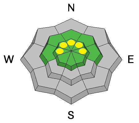
| type | aspect/elevation | characteristics |
|---|

|
|
LIKELIHOOD
LIKELY
UNLIKELY
SIZE
 LARGE
SMALL
TREND
INCREASING DANGER
SAME
DECREASING DANGER
|
|
description
The snow is stable and avalanches are unlikely on most slopes, but you still have to use common sense. There is always some inherent risk associated with wintertime mountain travel. Continue to use safe travel protocols, expose only one person at a time to avalanche danger, and carry and practice with your avalanche rescue equipment.
|
 |
weather Expect mostly sunny weather in the mountains today, with moderate east-northeast wind, and high temperature at 8500' of around 36 degrees. It'll be clear tonight with temperatures dropping to around 20 degrees. Expect increasing clouds tomorrow with high temperatures around 32 degrees and moderate west wind. There is a good chance for a little bit of light snow early next week... Check out our one-stop weather page........HERE
|
| general announcements RESEARCH PROJECT ON UNDERSTANDING TRAVEL BEHAVIOR IN AVALANCHE TERRAIN NEEDS YOU!! Scientists from the Snow and Avalanche Lab at Montana State University are seeking more participants for their project examining decision making and travel in avalanche terrain. Their project aims to collect GPS location information (from your smartphone) and survey responses from backcountry skiers and riders to better understand what types of terrain are used, and how decisions are made. Their focus is on backcountry skiers and riders of all abilities and experience. More information: If you want to participate, or learn more about their project aims, research questions and approaches, please visit their web page: www.montana.edu/snowscience/tracks or their companion site directed toward snowmobilers at: www.montana.edu/snowscience/sleds You can now receive advisories by email for the Logan Zone. Go here for details. Get your advisory on your iPhone along with great navigation and rescue tools, with our updated, Utah Avalanche Center mobile app Discount lift tickets are now available at Backcountry.com. Thanks to Ski Utah and the Utah Resorts. All proceeds go towards paying for Utah Avalanche Center avalanche and mountain weather advisories. Benefit the Utah Avalanche Center when you shop from Backcountry.com or REI: Click this link for Backcountry.com or this link to REI, shop, and they will donate a percent of your purchase price to the UAC. Both offer free shipping (with some conditions) so this costs you nothing! Benefit the Utah Avalanche Center when you buy or sell on ebay - set the Utah Avalanche Center as a favorite non-profit in your ebay account here and click on ebay gives when you buy or sell. You can choose to have your seller fees donated to the UAC, which doesn't cost you a penny. ***Please submit snow and avalanche observations from your ventures in the backcountry HERE. You can call us at 801-524-5304 or email HERE, or include #utavy in your Instagram or Tweet us @UAClogan. To report avalanche activity in the Logan Area or to contact the local avalanche forecaster call me, Toby, at 435-757-7578. I'll regularly update this advisory on Monday, Wednesday, Friday, and Saturday mornings by about 7:30. This advisory is produced by the U.S.D.A. Forest Service, which is solely responsible for its content. It describes only general avalanche conditions and local variations always exist. |


_1.jpg)