| During the month of April, Mark Miller will donate $75 to the charity of your choice (5 to chose from, including the Utah Avalanche Center!) Mark Miller Subaru has raised over $300k in the previous 6 Do Good Feel Good events. More Info here |  |
| During the month of April, Mark Miller will donate $75 to the charity of your choice (5 to chose from, including the Utah Avalanche Center!) Mark Miller Subaru has raised over $300k in the previous 6 Do Good Feel Good events. More Info here | |
| Advisory: Logan Area Mountains | Issued by Toby Weed for Monday - January 26, 2015 - 7:05am |
|---|

|
bottom line Very warm temperatures will create heightened avalanche conditions and a MODERATE (level 2) danger on many slopes in the backcountry as surface snow becomes saturated. Dangerous heat-related or wet avalanche conditions and a CONSIDERABLE (level 3) danger may develop with midday heating on some sunny upper elevation slopes.
|
 |
special announcement ***Check out and comment on our Practicing Companion Rescue video........HERE Sign up now for Avalanche Awareness for Snowmobilers with the UAC in Logan, February 5th and 7th. --The CROWBAR, Logan's own world class ski mountaineering race will be held in an all backcountry venue at Sink Hollow in Logan Canyon, Saturday, January 31. For more information and to register go..... HERE |
 |
current conditions It's already 41 degrees this morning at 9700', according to the CSI Logan Peak weather station, and unseasonably hot temperatures today will hopefully be the peak of this unwelcome January thaw. Over the weekend, low clouds formed rime at upper elevations and saturated the surface snow even in shady pockets. The snow is quite variable across the zone, with sun and melt/freeze crusts at lower elevations and on sun exposed slopes and wind-jacked and moist weakening surface snow up higher. Very warm temperatures forecast for upper elevations today are a cause of uncertainty and may well create dangerous avalanche conditions on steep slopes with saturated snow.
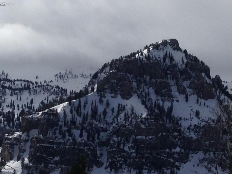
Unseasonably warm temperatures will create dangerous wet avalanche conditions in steep upper elevation terrain today. (photo of Mt. Gog on 1-23-15) ***1-23-15 Observation from Boiler Bowl and Magic Land...... HERE Video Observation 1-23-15.......... HERE
|
 |
recent activity
Visit our Backcountry Observations Page for more local information and from across the state.
|
| type | aspect/elevation | characteristics |
|---|

|

|
LIKELIHOOD
 LIKELY
UNLIKELY
SIZE
 LARGE
SMALL
TREND
 INCREASING DANGER
SAME
DECREASING DANGER
|
|
description
Forecast high temperatures at 9000' will reach the mid fifties today, which is somewhere around 20 degrees warmer than yesterday's. Rapid change is something avalanche forecasters watch out for, and rapid warming like we'll see today is a significant red flag. Heightened avalanche conditions will develop at all elevations with midday heat today, and the jump in temperatures is likely to create dangerous wet and/or heat related avalanche conditions on steep slopes with saturated snow. Natural avalanches are possible and triggered avalanches likely on some steep slopes in the heat of the day.
|
| type | aspect/elevation | characteristics |
|---|

|
|
LIKELIHOOD
 LIKELY
UNLIKELY
SIZE
LARGE
SMALL
TREND
INCREASING DANGER
SAME
DECREASING DANGER
|
|
description
Warming will soften existing hard slabs, creating a heightened danger on slopes with poor snow structure. Persistent slab avalanches are possible on some isolated upper elevation slopes and on sunny slopes in very steep mountain terrain.
|
 |
weather Expect calm winds, sunny skies, and very warm temperatures in the mountains, with a high temperature at 9000' expected to be around 54 degrees. Temperatures will drop to near freezing overnight. Tomorrow we'll see increasing cloudiness and south winds with a high around 42 degrees and a chance for some snow showers in the evening. We could see a couple inches of snow tomorrow night, but don't get your hopes up for much in the way of fresh powder... Check out our one-stop weather page........HERE
|
| general announcements Special thanks to Buttar's and ArcticCat for hooking us up with the light and powerful M8000. This machine will make our field days more fun, safe, and productive and will significantly boost our outreach and education efforts. You can now receive advisories by email for the Logan Zone. Go here for details. Get your advisory on your iPhone along with great navigation and rescue tools, with our updated, Utah Avalanche Center mobile app Discount lift tickets are now available at Backcountry.com. Thanks to Ski Utah and the Utah Resorts. All proceeds go towards paying for Utah Avalanche Center avalanche and mountain weather advisories. Benefit the Utah Avalanche Center when you shop from Backcountry.com or REI: Click this link for Backcountry.com or this link to REI, shop, and they will donate a percent of your purchase price to the UAC. Both offer free shipping (with some conditions) so this costs you nothing! Benefit the Utah Avalanche Center when you buy or sell on ebay - set the Utah Avalanche Center as a favorite non-profit in your ebay account here and click on ebay gives when you buy or sell. You can choose to have your seller fees donated to the UAC, which doesn't cost you a penny. Please submit snow and avalanche observations from your ventures in the backcountry HERE. You can call us at 801-524-5304 or email HERE, or include #utavy in your Instagram or Tweet us @UAClogan. To report avalanche activity in the Logan Area or to contact the local avalanche forecaster call me, Toby, at 435-757-7578. I'll regularly update this advisory on Monday, Wednesday, Friday, and Saturday mornings by about 7:30. This advisory is produced by the U.S.D.A. Forest Service, which is solely responsible for its content. It describes only general avalanche conditions and local variations always exist. |


_1.jpg)