| During the month of April, Mark Miller will donate $75 to the charity of your choice (5 to chose from, including the Utah Avalanche Center!) Mark Miller Subaru has raised over $300k in the previous 6 Do Good Feel Good events. More Info here |  |
| During the month of April, Mark Miller will donate $75 to the charity of your choice (5 to chose from, including the Utah Avalanche Center!) Mark Miller Subaru has raised over $300k in the previous 6 Do Good Feel Good events. More Info here | |
| Advisory: Logan Area Mountains | Issued by Toby Weed for Saturday - January 24, 2015 - 6:24am |
|---|

|
bottom line The snow is stable on most slopes, avalanches are generally unlikely, and there's an overall LOW (level 1) danger in the backcountry. Even so, you still might trigger avalanches on some previously drifted upper elevation slopes and in very steep (or "extreme") mountain terrain.
|
 |
special announcement Sign up now for Avalanche Awareness for Snowmobilers with the UAC in Logan, February 5th and 7th. ***The Snowbasin Ski Patrol is hosting a Full Avalanche Rescue Scenario with guest participation today at 10 am. Meet at the top of the Needles Gondola. Everyone is invited and encouraged to participate. --The CROWBAR, Logan's own world class ski mountaineering race will be held in an all backcountry venue at Sink Hollow in Logan Canyon next Saturday, January 31. For more information and to register go..... HERE |
 |
current conditions Riding conditions are fairly good, on mostly supportable and generally stable snow, and you can still find pockets with nice fast, re-crystallized snow in shady sheltered terrain. Overall, the snow surface conditions are quite variable, with sun and melt/freeze crusts at lower elevation and on sun exposed slopes and wind-jacked and weakening surface snow up higher. The 8400' Tony Grove Snotel reports an inch or two of new snow overnight. There's 59 inches of total snow containing 109% of average water for the date, and its 24 degrees this morning. The UDOT Hwy 89 Logan Summit weather station is reporting 14 degrees, with fairly light north winds.
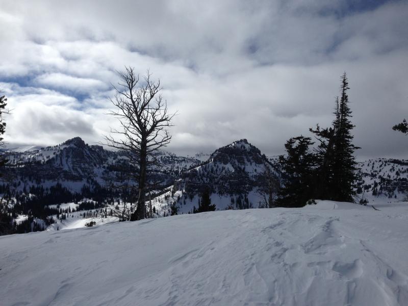
Wind-jacked snow in exposed terrain. Not much in the way of powder snow these days. Looking into White Pine Canyon from top of Boiler Bowl. (1-23-15) ***1-23-15 Observation from Boiler Bowl and Magic Land...... HERE ***YouTube Video Observation 1-23-15.......... HERE
|
 |
recent activity
Visit our Backcountry Observations Page for more local information and from across the state.
|
| type | aspect/elevation | characteristics |
|---|

|

|
LIKELIHOOD
 LIKELY
UNLIKELY
SIZE
 LARGE
SMALL
TREND
 INCREASING DANGER
SAME
DECREASING DANGER
|
|
description
The snow is stable in most areas, but you still might trigger avalanches in the backcountry, especially in wind exposed upper elevation areas and "extreme" terrain. While it's a great time to get out and explore, you still need to follow safe travel protocols, use good situational awareness, and carry your rescue gear. It's also a good time to practice companion rescue techniques. ****Check out and comment on our Practicing Companion Rescue video.........HERE
|
| type | aspect/elevation | characteristics |
|---|

|

|
LIKELIHOOD
LIKELY
UNLIKELY
SIZE
 LARGE
SMALL
TREND
INCREASING DANGER
SAME
DECREASING DANGER
|
|
description
Avalanches are generally unlikely, but persistent slab avalanches are possible on some isolated, previously drifted, upper elevation slopes and in very steep mountain terrain. The snow is sugary and lacks cohesion in some upper elevation areas with shallow snow-cover, and in some cases wind slabs late last week built up on slopes with poor snow structure, weak surface snow, or perhaps preserved feathery surface hoar.
|
 |
weather It'll be mostly cloudy today, with high temperatures at 8500' expected to be around 36 degrees, and a 15 mph northwest wind is expected on the ridges. Expect decreasing clouds overnight, low temperatures around 28 degrees, and moderate west wind. Expect warming conditions and fair weather in the mountains in the next couple days, with high temperatures in the lower 40s tomorrow and in the mid to upper 40s on Monday. Looking ahead, it might snow a bit early next week beginning around Tuesday as a quick hitting storm with tropical moisture moves through Utah, but most of the energy will likely pass to our south. Check out our one-stop weather page........HERE
|
| general announcements Special thanks to Buttar's and ArcticCat for hooking us up with the light and powerful M8000. This machine will make our field days more fun, safe, and productive and will significantly boost our outreach and education efforts. You can now receive advisories by email for the Logan Zone. Go here for details. Get your advisory on your iPhone along with great navigation and rescue tools, with our updated, Utah Avalanche Center mobile app Discount lift tickets are now available at Backcountry.com. Thanks to Ski Utah and the Utah Resorts. All proceeds go towards paying for Utah Avalanche Center avalanche and mountain weather advisories. Benefit the Utah Avalanche Center when you shop from Backcountry.com or REI: Click this link for Backcountry.com or this link to REI, shop, and they will donate a percent of your purchase price to the UAC. Both offer free shipping (with some conditions) so this costs you nothing! Benefit the Utah Avalanche Center when you buy or sell on ebay - set the Utah Avalanche Center as a favorite non-profit in your ebay account here and click on ebay gives when you buy or sell. You can choose to have your seller fees donated to the UAC, which doesn't cost you a penny. Please submit snow and avalanche observations from your ventures in the backcountry HERE. You can call us at 801-524-5304 or email HERE, or include #utavy in your Instagram or Tweet us @UAClogan. To report avalanche activity in the Logan Area or to contact the local avalanche forecaster call me, Toby, at 435-757-7578. I'll regularly update this advisory on Monday, Wednesday, Friday, and Saturday mornings by about 7:30. This advisory is produced by the U.S.D.A. Forest Service, which is solely responsible for its content. It describes only general avalanche conditions and local variations always exist. |


_1.jpg)