| During the month of April, Mark Miller will donate $75 to the charity of your choice (5 to chose from, including the Utah Avalanche Center!) Mark Miller Subaru has raised over $300k in the previous 6 Do Good Feel Good events. More Info here |  |
| During the month of April, Mark Miller will donate $75 to the charity of your choice (5 to chose from, including the Utah Avalanche Center!) Mark Miller Subaru has raised over $300k in the previous 6 Do Good Feel Good events. More Info here | |
| Advisory: Logan Area Mountains | Issued by Toby Weed for Wednesday - January 21, 2015 - 7:06am |
|---|

|
bottom line The snow is stable on most slopes, avalanches are generally unlikely, and there's a LOW (level 1) danger overall in the backcountry. However, pockets with heightened conditions and MODERATE (level 2) danger remain in some previously drifted upper elevation terrain.
|
 |
special announcement Sign up now for Avalanche Awareness for Snowmobilers with the UAC in Logan, February 5th and 7th.
|
 |
current conditions As is the case across the state, the Logan Zone lacks low elevation snow, and access to upper elevations from many local trail-heads is difficult due to dry and rocky conditions. Still, a bit more than average water in the snow up high. Riding conditions are fairly good, on mostly supportable and generally stable snow, and you can still find nice settled powder-like snow in shady sheltered terrain. The 8400' Tony Grove Snotel reports 60 inches of total snow containing 112% of average water for the date, and its 13 degrees this morning. The UDOT Hwy 89 Logan Summit weather station is reporting negative 5 degrees, with light east winds.
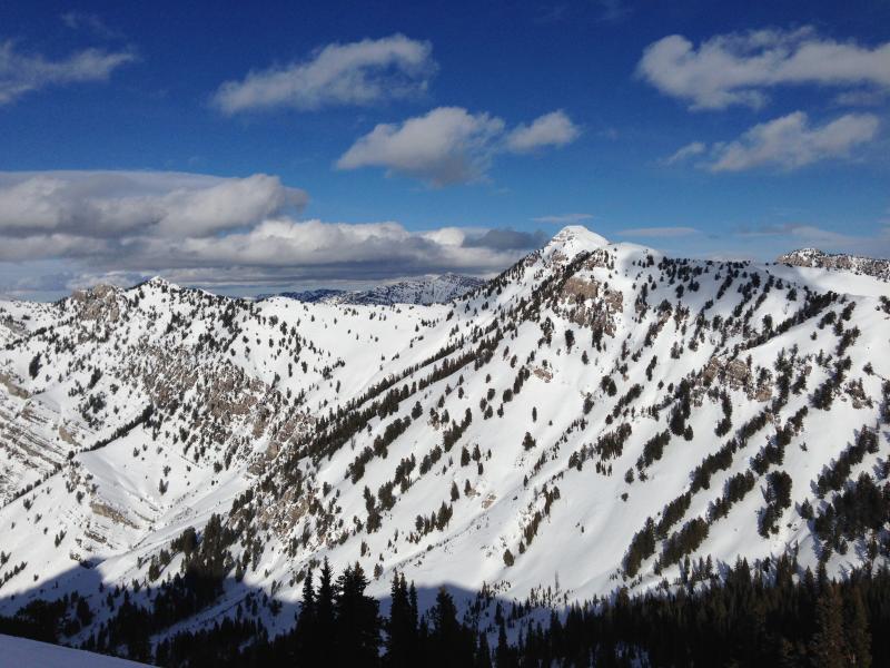
Cherry Peak in the Mount Naomi Wilderness, with pretty good snow coverage as seen from the south. (1-19-15)
|
 |
recent activity
Visit our Backcountry Observations Page for more local information and from across the state.
|
| type | aspect/elevation | characteristics |
|---|

|
|
LIKELIHOOD
 LIKELY
UNLIKELY
SIZE
 LARGE
SMALL
TREND
 INCREASING DANGER
SAME
DECREASING DANGER
|
|
description
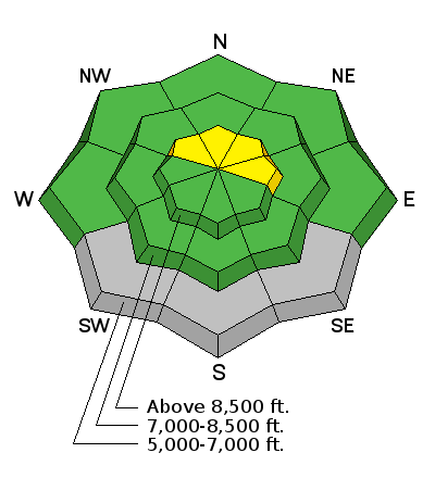
A few pockets with heightened conditions remain, and triggered slab avalanches are possible on some previously drifted upper elevation slopes. Some wind slabs late last week built up on weak surface snow, and perhaps in some cases, preserved feathery surface hoar.
|
| type | aspect/elevation | characteristics |
|---|

|
|
LIKELIHOOD
LIKELY
UNLIKELY
SIZE
LARGE
SMALL
TREND
INCREASING DANGER
SAME
DECREASING DANGER
|
|
description
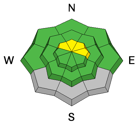
The snow is stable in most areas, but you still might trigger avalanches in the backcountry, especially in wind exposed upper elevation areas and "extreme" terrain. While it's a great time to get out and explore, you still need to follow safe travel protocols, use good situational awareness, and carry your rescue gear. It's also a good time to practice companion rescue techniques. ****Check out and comment on our Practicing Companion Rescue video.........HERE
|
 |
weather We don't see much in the way of storms in the near future, with a rather stagnant weather pattern apparently setting up for the foreseeable future. It'll be sunny today in the mountains with a high temperature at 8500' around 24 degrees and moderate northwest wind. Temperatures will drop into the lower teens in most areas overnight, but may sink into the sub-zero zone in the Sinks Country again as well... Check out our one-stop weather page........HERE
|
| general announcements Special thanks to Buttar's and ArcticCat for hooking us up with the light and powerful M8000. This machine will make our field days more fun, safe, and productive and will significantly boost our outreach and education efforts. You can now receive advisories by email for the Logan Zone. Go here for details. Get your advisory on your iPhone along with great navigation and rescue tools, with our updated, Utah Avalanche Center mobile app Discount lift tickets are now available at Backcountry.com. Thanks to Ski Utah and the Utah Resorts. All proceeds go towards paying for Utah Avalanche Center avalanche and mountain weather advisories. Benefit the Utah Avalanche Center when you shop from Backcountry.com or REI: Click this link for Backcountry.com or this link to REI, shop, and they will donate a percent of your purchase price to the UAC. Both offer free shipping (with some conditions) so this costs you nothing! Benefit the Utah Avalanche Center when you buy or sell on ebay - set the Utah Avalanche Center as a favorite non-profit in your ebay account here and click on ebay gives when you buy or sell. You can choose to have your seller fees donated to the UAC, which doesn't cost you a penny. Please submit snow and avalanche observations from your ventures in the backcountry HERE. You can call us at 801-524-5304 or email HERE, or include #utavy in your Instagram or Tweet us @UAClogan. To report avalanche activity in the Logan Area or to contact the local avalanche forecaster call me, Toby, at 435-757-7578. I'll regularly update this advisory on Monday, Wednesday, Friday, and Saturday mornings by about 7:30. This advisory is produced by the U.S.D.A. Forest Service, which is solely responsible for its content. It describes only general avalanche conditions and local variations always exist. |


_1.jpg)