
| During the month of April, Mark Miller will donate $75 to the charity of your choice (5 to chose from, including the Utah Avalanche Center!) Mark Miller Subaru has raised over $300k in the previous 6 Do Good Feel Good events. More Info here |  |
| During the month of April, Mark Miller will donate $75 to the charity of your choice (5 to chose from, including the Utah Avalanche Center!) Mark Miller Subaru has raised over $300k in the previous 6 Do Good Feel Good events. More Info here | |
| Advisory: Logan Area Mountains | Issued by Toby Weed for Monday - January 12, 2015 - 6:59am |
|---|

|
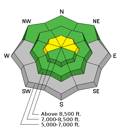
bottom line Heightened avalanche conditions are developing and the danger will rise to MODERATE (level 2) at upper elevations in the backcountry. Accumulating snowfall and a breeze from the south will cause the danger of storm snow and soft wind slab avalanches to rise throughout the day.
|
 |
current conditions The 8400' Tony Grove Snotel reports 2 inches of new snow containing 0.3" of water. There's 57 inches of total snow containing 125% of average water for the date, and its 28 degrees this morning. A couple inches of fresh snow can do wonders for conditions, and a couple more will probably fall today. Expect to find a couple inches of fresh medium density snow on crust in most areas today... The new snow might have capped and preserved surface hoar that was widespread on the old snow surface and especially the shady protected areas.
Frost crystals or surface hoar formed on Monday's rime-crust at upper elevations in Steep Hollow. (1-9-2015)
|
 |
recent activity No avalanches reported locally since last week's natural wet activity. Visit our Backcountry Observations Page for more information.....
|
| type | aspect/elevation | characteristics |
|---|

|
|
LIKELIHOOD
 LIKELY
UNLIKELY
SIZE
 LARGE
SMALL
TREND
 INCREASING DANGER
SAME
DECREASING DANGER
|
|
description
Manageable fresh soft slabs consisting of new snow are possible in some upper elevation terrain, and more snow or wind than expected could create heightened avalanche conditions on some slopes. Soft wind slabs should be manageable, but even a small avalanche is likely go fast and far on a nice smooth hard bed surface. The danger will increase throughout the day, with increasing snowfall and light to moderate south winds.
|
 |
weather Expect snowfall, with 3 to 5 inches of accumulation, high temperatures around 31 degrees at 8500' and a moderate south wind. A couple more inches of accumulation is possible tonight, with temperatures dropping below 20 degrees and winds veering from the north-northwest. Expect clearing conditions tomorrow with temperatures in the mid twenties and a north wind. A high pressure system will rebuild over Utah midweek but shortwaves to the north will hopefully keep the inversion weak and give us in the far north a chance for some cloudiness and light snowfall. The next possibility of a more significant storm is about a week out. Check out our one-stop weather page........HERE
|
| general announcements You can now receive advisories by email for each region in the state including Logan. Go here for details. Get your advisory on your iPhone along with great navigation and rescue tools....... Utah Avalanche Center mobile app Please submit snow and avalanche observations from your ventures in the backcountry HERE. You can call us at 801-524-5304 or email HERE, or include #utavy in your Instagram or Tweet us @UAClogan. To report avalanche activity in the Logan Area or to contact the local avalanche forecaster call me, Toby, at 435-757-7578. I'll regularly update this advisory on Monday, Wednesday, Friday, and Saturday mornings by about 7:30. This advisory is produced by the U.S.D.A. Forest Service, which is solely responsible for its content. It describes only general avalanche conditions and local variations always exist. |


_1.jpg)

