
| During the month of April, Mark Miller will donate $75 to the charity of your choice (5 to chose from, including the Utah Avalanche Center!) Mark Miller Subaru has raised over $300k in the previous 6 Do Good Feel Good events. More Info here |  |
| During the month of April, Mark Miller will donate $75 to the charity of your choice (5 to chose from, including the Utah Avalanche Center!) Mark Miller Subaru has raised over $300k in the previous 6 Do Good Feel Good events. More Info here | |
| Advisory: Logan Area Mountains | Issued by Toby Weed for Saturday - January 10, 2015 - 6:53am |
|---|

|
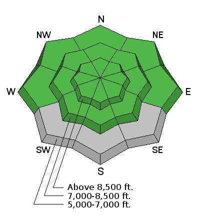
bottom line There's a LOW (level 1) avalanche danger in the backcountry, and the snow is generally stable in most areas. Persistent slab avalanches are unlikely yet still a possibility in some steep terrain with existing poor snow structure.
|
 |
current conditions The 8400' Tony Grove Snotel reports 55 inches of total snow containing 127% of average water for the date, and its 30 degrees this morning. Touring, boon-docking, and sight-seeing conditions are pretty good despite the lack of fresh powder in the backcountry.
Frost crystals or surface hoar formed on Monday's rime-crust at upper elevations in Steep Hollow. (1-9-2015) ****Observational and snowpit video from Burn Bowl on 1-5-2014....HERE
|
 |
recent activity Very warm temperatures earlier in the week caused widespread natural wet avalanche activity in steep sunny terrain...
Visit our Backcountry Observations Page for more information.....
|
| type | aspect/elevation | characteristics |
|---|

|
|
LIKELIHOOD
 LIKELY
UNLIKELY
SIZE
 LARGE
SMALL
TREND
 INCREASING DANGER
SAME
DECREASING DANGER
|
|
description
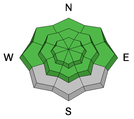
A low danger doesn't mean there is no possibility of triggering and avalanche. As Drew Hardesty puts it this morning, "Some risk is always inherent in mountain travel."
|
| type | aspect/elevation | characteristics |
|---|

|
|
LIKELIHOOD
LIKELY
UNLIKELY
SIZE
 LARGE
SMALL
TREND
INCREASING DANGER
SAME
DECREASING DANGER
|
|
description
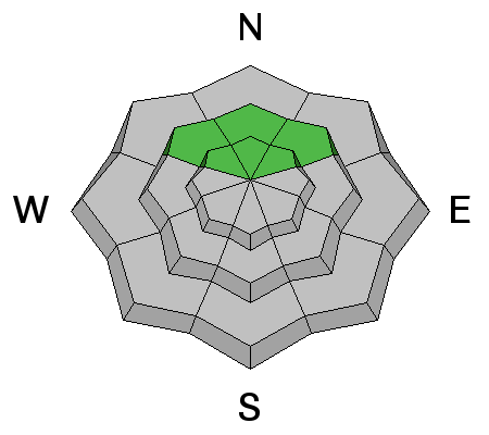
Slab avalanches running on buried weak layers are unlikely yet still a possibility in outlying or isolated terrain facing the northern half of the compass, and on previously drifted slopes with poor snow structure steeper than about 30 degrees.
|
 |
weather It'll be mostly cloudy and warm in the mountains today with a high temperature of 38 degrees at 8500' and moderate southwest wind. Expect cloudy conditions tonight, with a low temperature around 25 degrees and a good chance for a bit of snowfall but little in the way of accumulation. Same thing Sunday, good chance for some snowfall, but not much accumulation. Our best chance for and inch or two of accumulation will come Monday and Monday night, but don't expect very much. Check out our one-stop weather page........HERE
|
| general announcements You can now receive advisories by email for each region in the state including Logan. Go here for details. Get your advisory on your iPhone along with great navigation and rescue tools....... Utah Avalanche Center mobile app Please submit snow and avalanche observations from your ventures in the backcountry HERE. You can call us at 801-524-5304 or email HERE, or include #utavy in your Instagram or Tweet us @UAClogan. To report avalanche activity in the Logan Area or to contact the local avalanche forecaster call me, Toby, at 435-757-7578. I'll regularly update this advisory on Monday, Wednesday, Friday, and Saturday mornings by about 7:30. This advisory is produced by the U.S.D.A. Forest Service, which is solely responsible for its content. It describes only general avalanche conditions and local variations always exist. |


_1.jpg)
