| During the month of April, Mark Miller will donate $75 to the charity of your choice (5 to chose from, including the Utah Avalanche Center!) Mark Miller Subaru has raised over $300k in the previous 6 Do Good Feel Good events. More Info here |  |
| During the month of April, Mark Miller will donate $75 to the charity of your choice (5 to chose from, including the Utah Avalanche Center!) Mark Miller Subaru has raised over $300k in the previous 6 Do Good Feel Good events. More Info here | |
| Advisory: Logan Area Mountains | Issued by Toby Weed for Friday - January 9, 2015 - 7:13am |
|---|


|
bottom line There's a MODERATE (level 2) danger in the backcountry, and heightened avalanche conditions exist. Warm daytime temperatures will again create potential for wet avalanches on steep slopes with saturated snow. Dangerous persistent slab avalanches are unlikely yet still possible in some steep terrain with existing poor snow structure.
|
 |
current conditions The 8400' Tony Grove Snotel reports 56 inches of total snow containing 130% of average water for the date, and its 31 degrees this morning. The wind sensor is still not reading at the CSI Logan Peak weather station, and it's 30 degrees at 9700'. Not much in the way of nice powder out there anymore, after recent strong winds, rime, and exceptionally warm temperatures. These are good days to get out and enjoy the nice weather in the mountains. Touring, riding, and sight seeing conditions are pretty good despite the lack of powder in the backcountry.
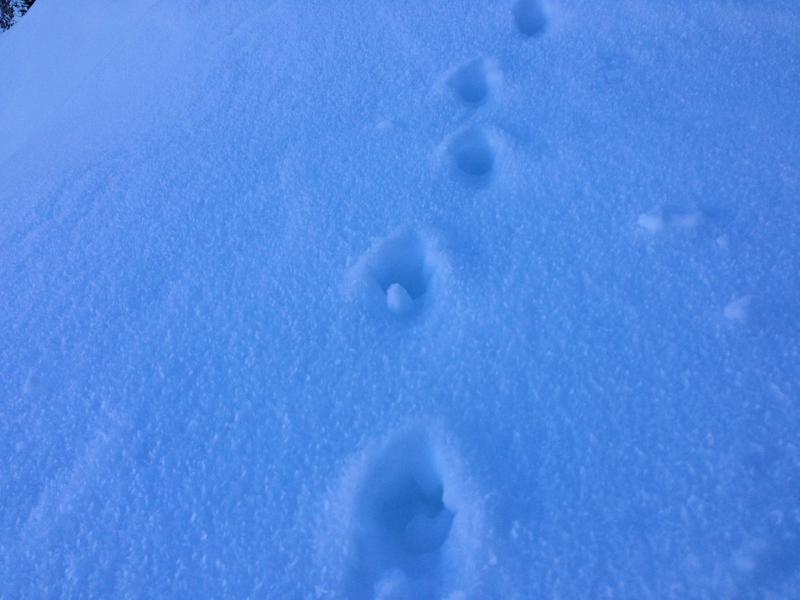
Coyote tracks through frost crystals or surface hoar in shady upper elevation terrain in Providence Canyon. (1-7-2015) ****Observational and snowpit video from Burn Bowl on 1-5-2014....HERE
|
 |
recent activity I ran across a fresh natural wind slab avalanche on Monday, (1-5-2015). Very warm temperatures in the past few days caused significant natural loose wet avalanche activity in steep sunny terrain.
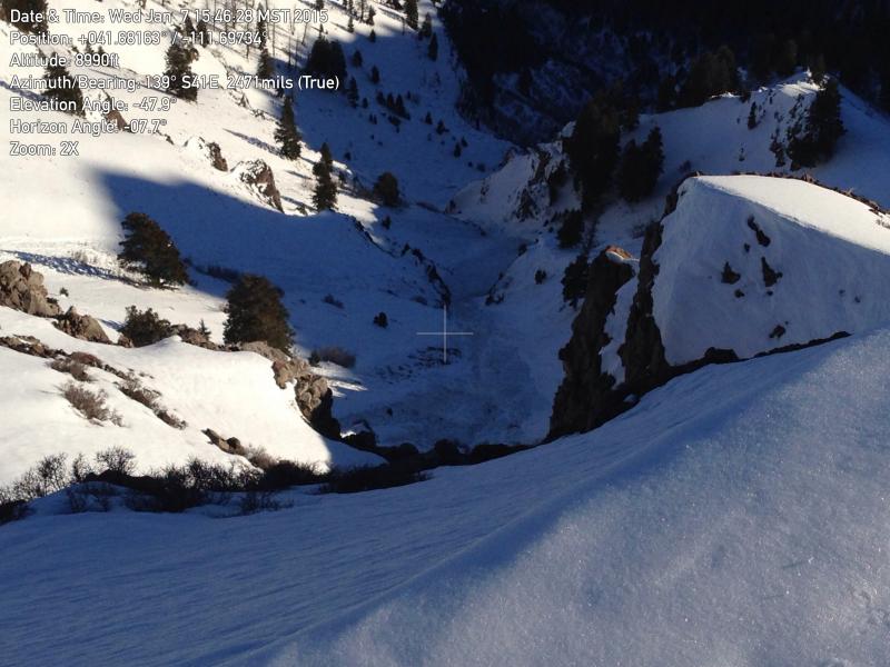
Looking down at a large natural wet avalanche in upper Charlie's Hollow. (1-7-2015) *****1-5-15 Wind Slab Avalanche Video Observation.......HERE Visit our Backcountry Observations Page for more information.....
|
| type | aspect/elevation | characteristics |
|---|

|
|
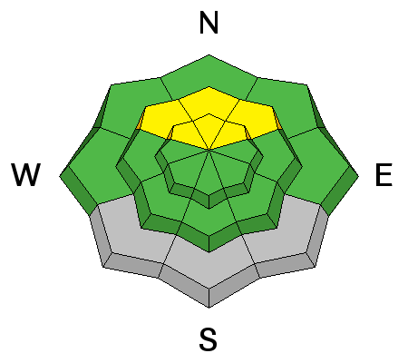
LIKELIHOOD
 LIKELY
UNLIKELY
SIZE
 LARGE
SMALL
TREND
 INCREASING DANGER
SAME
DECREASING DANGER
|
|
description
Dangerous persistent slab avalanches are rather unlikely, but they remain possible in outlying terrain facing the northern half of the compass, and on previously drifted slopes with poor snow structure steeper than about 30 degrees. Steep rocky slopes at mid and upper elevations that had shallow snow cover in December and now with wind deposits from last week's tempest are the most suspect. Warming temperatures probably softened the overlying slab in some cases, potentially allowing for easier triggering..
|
| type | aspect/elevation | characteristics |
|---|

|
|
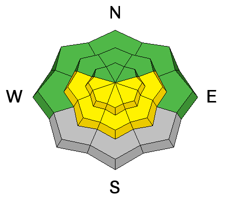
LIKELIHOOD
 LIKELY
UNLIKELY
SIZE
 LARGE
SMALL
TREND
 INCREASING DANGER
SAME
DECREASING DANGER
|
|
description
Cooling temperatures will help as we head into the weekend. Even so, warm temperatures will again create heightened wet avalanche conditions today on slopes with saturated surface snow. Loose wet avalanches are most likely during the heat of midday, especially on sunny sheltered slopes. Natural wet sluffs are possible in some sunny terrain, and you might easily trigger wet slides on some steep slopes with soft wet snow. Avoid midday travel on or below steep sunny slopes.
|
 |
weather It'll be mostly sunny and warm in the mountains again today, with calm winds and 8500' high temperatures reaching around 41 degrees. Expect mostly cloudy skies tonight, with light southwest winds, and a low around 25. We'll see mostly cloudy skies tomorrow, with mountain high temperatures only around 33 degrees. Our next chance for a little fresh snow looks to be Sunday, with light accumulations possible on Monday. Check out our one-stop weather page........HERE
|
| general announcements You can now receive advisories by email for each region in the state including Logan. Go here for details. Get your advisory on your iPhone along with great navigation and rescue tools....... Utah Avalanche Center mobile app Please submit snow and avalanche observations from your ventures in the backcountry HERE. You can call us at 801-524-5304 or email HERE, or include #utavy in your Instagram or Tweet us @UAClogan. To report avalanche activity in the Logan Area or to contact the local avalanche forecaster call me, Toby, at 435-757-7578. I'll regularly update this advisory on Monday, Wednesday, Friday, and Saturday mornings by about 7:30. This advisory is produced by the U.S.D.A. Forest Service, which is solely responsible for its content. It describes only general avalanche conditions and local variations always exist. |


_1.jpg)