| During the month of April, Mark Miller will donate $75 to the charity of your choice (5 to chose from, including the Utah Avalanche Center!) Mark Miller Subaru has raised over $300k in the previous 6 Do Good Feel Good events. More Info here |  |
| During the month of April, Mark Miller will donate $75 to the charity of your choice (5 to chose from, including the Utah Avalanche Center!) Mark Miller Subaru has raised over $300k in the previous 6 Do Good Feel Good events. More Info here | |
| Advisory: Logan Area Mountains | Issued by Toby Weed for Wednesday - December 31, 2014 - 6:59am |
|---|

|
bottom line Strong east winds created dangerous avalanche conditions and a CONSIDERABLE (level 3) danger on drifted slopes in the backcountry. You could trigger wind slab avalanches in drifted terrain at all elevations. Watch for new drifts in unusual or unexpected places. Although becoming more unlikely, you still might trigger a deeper, dangerous, and destructive persistent slab avalanche on a steep upper or mid-elevation slope facing the northern half of the compass.
|
 |
avalanche warning THIS AVALANCHE WARNING IS FOR CANYON MOUTHS AND FOOTHILLS OF CACHE...DAVIS...WEBER AND EASTERN SALT LAKE COUNTIES. STRONG WIND WILL CREATE POTENTIALLY DANGEROUS WIND SLAB AVALANCHE CONDITIONS IN LOW ELEVATION AREAS WHERE PEOPLE DO NOT NORMALLY SEE AVALANCHES. AVALANCHE DANGER IS EXPECTED THROUGH THE DAY TODAY. |
 |
special announcement We will offer an Avalanche Awareness Class, for beginners and as a refresher for those already with some training, including a Field Day in the backcountry. Class begins on January 8 (evening) and all day Saturday January 10. Call Paige at 435-757-2794 for more information. |
 |
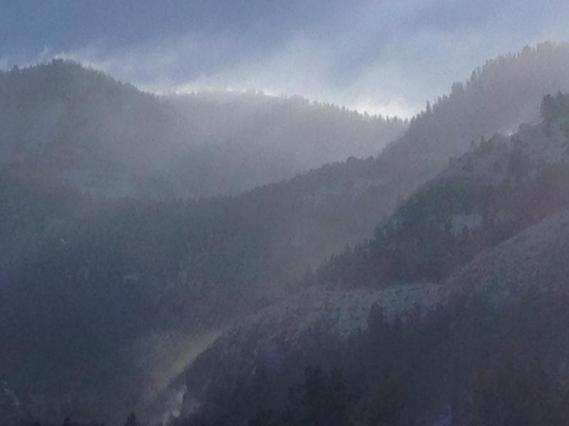
current conditions The Tony Grove Snotel reports 64 inches of total snow at the 8400' site containing 135% of average water for the date, and its 4 degrees this morning. The UDOT Hwy 89 Logan Summit weather station is showing fairly light east-northeast wind, and a chilly negative 13 degrees. Strong east winds yesterday changed the landscape and drifted snow into strange and perhaps unexpected places.
Strong east wind yesterday caused substantial drifting at all elevations. Logan Peak and Mill Hollow yesterday afternoon. (12-30-2014) Watch Cold East Wind video observation from yesterday, 12-30-2014............HERE
|
 |
recent activity
Visit our Backcountry Observations Page for more information.....
|
| type | aspect/elevation | characteristics |
|---|

|
|
LIKELIHOOD
 LIKELY
UNLIKELY
SIZE
 LARGE
SMALL
TREND
 INCREASING DANGER
SAME
DECREASING DANGER
|
|
description
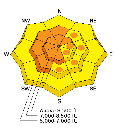
Yesterday's strong east wind event built wind slabs in strange and unexpected areas. Wind slabs tend to form in deposition areas on the lee side of ridge-lines and in and around terrain features like gullies, scoops, cliff-bands, and sub-ridges. These will appear rounded, perhaps chalky looking, and may be hollow sounding. Avoid fresh wind drifts and wind slabs on all slopes steeper than about 30 degrees. |
| type | aspect/elevation | characteristics |
|---|

|
|
LIKELIHOOD
 LIKELY
UNLIKELY
SIZE
 LARGE
SMALL
TREND
 INCREASING DANGER
SAME
DECREASING DANGER
|
|
description
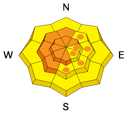
We're now in a tricky "Low Probability, High Consequence" situation. During the Solstice Storm, heavy wind-blown snow overloaded a weak layer consisting of faceted snow and surface hoar that was on the snow surface before the storm arrived. Dangerous and destructive triggered avalanches are becoming less likely but remain possible in some drifted terrain facing the northern half of the compass on slopes steeper than about 30 degrees. ****Video observation (snowpit) from Bobcat in the Wood Camp Area (12-27-2014)............HERE
|
 |
weather It'll be sunny and cold in the mountains again today, with 8500' temperatures around 13 degrees and continued strong but diminishing east winds. Expect wind chills on the ridges around 26 degrees below zero, dangerously cold. Expect below zero temperatures again tonight in the mountain sinks, with 8500' lows around 5 degrees and continuing cold east northeast wind. New Years Day will be sunny, with 8500' high temperatures around 23 and diminishing moderate northeast winds. A bit of snow is possible for the upcoming weekend, but accumulations look rather light at this point. Check out our one-stop weather page........HERE
|
| general announcements You can now receive advisories by email for each region in the state including Logan. Go here for details. Get your advisory on your iPhone along with great navigation and rescue tools....... Utah Avalanche Center mobile app Please submit snow and avalanche observations from your ventures in the backcountry HERE. You can call us at 801-524-5304 or email HERE, or include #utavy in your Instagram or Tweet us @UAClogan. To report avalanche activity in the Logan Area or to contact the local avalanche forecaster call me, Toby, at 435-757-7578. I'll regularly update this advisory on Monday, Wednesday, Friday, and Saturday mornings by about 7:30. This advisory is produced by the U.S.D.A. Forest Service, which is solely responsible for its content. It describes only general avalanche conditions and local variations always exist. |


_1.jpg)