| During the month of April, Mark Miller will donate $75 to the charity of your choice (5 to chose from, including the Utah Avalanche Center!) Mark Miller Subaru has raised over $300k in the previous 6 Do Good Feel Good events. More Info here |  |
| During the month of April, Mark Miller will donate $75 to the charity of your choice (5 to chose from, including the Utah Avalanche Center!) Mark Miller Subaru has raised over $300k in the previous 6 Do Good Feel Good events. More Info here | |
| Advisory: Logan Area Mountains | Issued by Toby Weed for Sunday - December 28, 2014 - 7:25am |
|---|

|
bottom line There's a CONSIDERABLE (level 3) avalanche danger, and substantial drifting today and fresh accumulations will create dangerous wind slab avalanche conditions at upper elevations. Although becoming less likely, you still might trigger a dangerous and destructive persistent slab avalanche on a steep upper or mid-elevation slope.
|
 |
special announcement We will offer an Avalanche Awareness Class, for beginners and as a refresher for those already with some training, including a Field Day in the backcountry. Class begins on January 8 (evening) and all day Saturday January 10. Call Paige at 435-757-2794 for more information. |
 |
current conditions The Tony Grove Snotel reports about 3 inches of new snow overnight and 62 inches of total snow at the 8400' site containing 135% of average water for the date, and its 13 degrees this morning. The UDOT Hwy 89 Logan Summit weather station is showing increasing northwest or up-canyon wind this morning, gusting into the mid 20s and 13 degrees. Lots of folks found very good powder conditions yesterday, and no one reported any avalanches. But, increasing winds will find plenty of light existing and accumulating powder and some easy drifting. Digging shows there is still potential for dangerous and destructive persistent slab avalanches, but the probability of triggering one is gradually diminishing to unlikely.
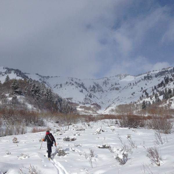
Still pretty shallow and bushy down low in Wood Camp. (12-27-2014)
|
 |
recent activity
Visit our Backcountry Observations Page for more information.....
|
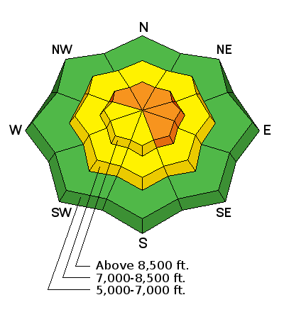
| type | aspect/elevation | characteristics |
|---|

|
|
LIKELIHOOD
 LIKELY
UNLIKELY
SIZE
 LARGE
SMALL
TREND
 INCREASING DANGER
SAME
DECREASING DANGER
|
|
description
We're now in a tricky "Low Probability, High Consequence" situation. During the Solstice Storm, heavy wind-blown snow overloaded a weak layer consisting of faceted snow and surface hoar that was on the snow surface before the storm arrived. Dangerous and destructive triggered avalanches remain possible in some terrain steeper than about 30 degrees. The danger will be most pronounced on drifted slopes facing the northern half of the compass. Audible collapsing or whoompfing noises indicate dangerous persistent slab avalanche potential. ****Video observation (snowpit) from Bobcat in the Wood Camp Area yesterday (12-27-2014)............HERE
|
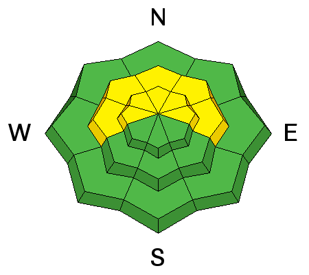
| type | aspect/elevation | characteristics |
|---|

|
|
LIKELIHOOD
 LIKELY
UNLIKELY
SIZE
 LARGE
SMALL
TREND
 INCREASING DANGER
SAME
DECREASING DANGER
|
|
description
Drifting of the light powder snow currently on the surface will rapidly increase the potential for fresh wind slab avalanches. Expect windy conditions today, with increasing west winds and significant drifting of fresh and accumulating powder snow in exposed upper elevation terrain. Avoid fresh drifts on the lee side of ridge-lines and in and around terrain features like gullies, scoops, cliff-bands, and sub-ridges.
|
 |
weather Expect stormy weather in the mountains today, with fairly strong and sustained west winds, temperatures in the mid teens, sub-zero wind chills, and 4 to 8 inches of accumulation at 8500' by evening. Snow will taper off to showers tonight and continue through Monday, and it'll be a cold and mostly cloudy day. Another 2 to 6 inches of fluffy powder is likely overnight and tomorrow. Check out our one-stop weather page........HERE
|
| general announcements You can now receive advisories by email for each region in the state including Logan. Go here for details. Get your advisory on your iPhone along with great navigation and rescue tools....... Utah Avalanche Center mobile app Please submit snow and avalanche observations from your ventures in the backcountry HERE. You can call us at 801-524-5304 or email HERE, or include #utavy in your Instagram or Tweet us @UAClogan. To report avalanche activity in the Logan Area or to contact the local avalanche forecaster call me, Toby, at 435-757-7578. I'll regularly update this advisory on Monday, Wednesday, Friday, and Saturday mornings by about 7:30. This advisory is produced by the U.S.D.A. Forest Service, which is solely responsible for its content. It describes only general avalanche conditions and local variations always exist. |


_1.jpg)