
| During the month of April, Mark Miller will donate $75 to the charity of your choice (5 to chose from, including the Utah Avalanche Center!) Mark Miller Subaru has raised over $300k in the previous 6 Do Good Feel Good events. More Info here |  |
| During the month of April, Mark Miller will donate $75 to the charity of your choice (5 to chose from, including the Utah Avalanche Center!) Mark Miller Subaru has raised over $300k in the previous 6 Do Good Feel Good events. More Info here | |
| Advisory: Logan Area Mountains | Issued by Toby Weed for Thursday - December 25, 2014 - 6:01am |
|---|

|
bottom line There's a CONSIDERABLE (level 3) avalanche danger, and dangerous avalanche conditions exist on drifted slopes. You are likely to trigger wind slab avalanches in drifted terrain steeper than about 30 degrees. Persistent slab avalanches might be remote triggered from a distance, or worse, from below.
|
 |
current conditions The Tony Grove Snotel reports 4 inches of new containing 0.4" of water. There's 59 inches of total snow at the 8400' site containing 136% of average water for the date, and its 20 degrees this morning. The CSI Logan Peak wind sensor appears to be rimed once again, but Mt. Ogden reported very strong south winds yesterday, and you could see snow drifting off the peaks. The UDOT Hwy 89 Logan Summit weather station is reading 20 degrees and 10 mph (west) winds. Dangerous avalanche conditions persist in the backcountry, and a Christmas storm will create increasing avalanche danger during the day, with rapid accumulations at times and drifting snow.
Visible drifting and plumes flagging off the Wellsville Range yesterday. (Flygare 12-24-2014)
|
 |
recent activity
Visit our Backcountry Observations Page for more information.....
A sled triggered avalanche in the Rodeo Grounds on Tuesday, 12-23-2014
|
| type | aspect/elevation | characteristics |
|---|

|
|
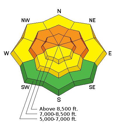
LIKELIHOOD
 LIKELY
UNLIKELY
SIZE
 LARGE
SMALL
TREND
 INCREASING DANGER
SAME
DECREASING DANGER
|
|
description
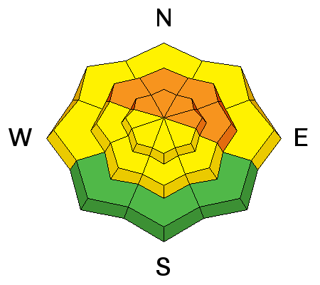
Strong south winds yesterday drifted significant snow in exposed terrain, creating stiff wind slabs on the lee sides of the major ridges and in and around terrain features like gullies and cliff bands. These drifts will be now hidden by several inches of fresh snow and ongoing drifting of the powder. Watch for both hidden older stiff wind slabs and sensitive building fresh wind slabs. Best choice for today is to avoid steep drifted terrain.
|
| type | aspect/elevation | characteristics |
|---|

|
|
LIKELIHOOD
LIKELY
UNLIKELY
SIZE
 LARGE
SMALL
TREND
INCREASING DANGER
SAME
DECREASING DANGER
|
|
description
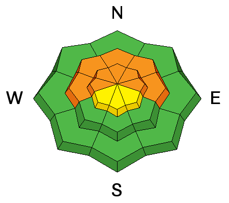
During the Solstice Storm, heavy wind-blown snow overloaded a very weak layer consisting of faceted snow, surface hoar that was on the snow surface before the storm arrived. The added weight of today's storm may be enough to overload slopes or bring then back into a balanced state. Triggered avalanches are likely in some terrain steeper than about 30 degrees, and you could remote trigger avalanches from a distance or below. The danger will be most pronounced at upper elevations, on drifted slopes facing the northern half of the compass. Audible collapsing or whoompfing noises indicates dangerous persistent slab avalanche potential.
|
 |
weather The National Weather Service has continued a Winter Storm Warning for a widespread area, including the mountains and valleys of Northern Utah and Southeast Idaho. Expect snow in the mountains and valleys today, and poor traveling conditions. We're looking at 4 to 8 inches of accumulation today, temperatures at 8500' in the mid teens, and moderate northwest winds. Snow showers will continue tonight, with an additional 2 to 4 inches possible and low temperatures around 12 degrees. More significant snowfall in our region is expected Saturday night and Sunday. Check out our one-stop weather page........HERE
|
| general announcements You can now receive advisories by email for each region in the state including Logan. Go here for details. Get your advisory on your iPhone along with great navigation and rescue tools....... Utah Avalanche Center mobile app Please submit snow and avalanche observations from your ventures in the backcountry HERE. You can call us at 801-524-5304 or email HERE, or include #utavy in your Instagram or Tweet us @UAClogan. To report avalanche activity in the Logan Area or to contact the local avalanche forecaster call me, Toby, at 435-757-7578. I'll regularly update this advisory on Monday, Wednesday, Friday, and Saturday mornings by about 7:30. This advisory is produced by the U.S.D.A. Forest Service, which is solely responsible for its content. It describes only general avalanche conditions and local variations always exist. |


_1.jpg)

 copy.jpeg)