
| During the month of April, Mark Miller will donate $75 to the charity of your choice (5 to chose from, including the Utah Avalanche Center!) Mark Miller Subaru has raised over $300k in the previous 6 Do Good Feel Good events. More Info here |  |
| During the month of April, Mark Miller will donate $75 to the charity of your choice (5 to chose from, including the Utah Avalanche Center!) Mark Miller Subaru has raised over $300k in the previous 6 Do Good Feel Good events. More Info here | |
| Advisory: Logan Area Mountains | Issued by Toby Weed for Wednesday - December 24, 2014 - 7:21am |
|---|

|
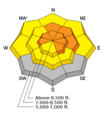
bottom line There's a CONSIDERABLE (level 3) avalanche danger, and dangerous avalanche conditions exist on drifted upper elevation slopes that did not naturally avalanche recently.
|
 |
current conditions The Tony Grove Snotel reports an inch of new and 56 inches of total snow containing 134% of average water for the date. It's 21 degrees this morning at the well-representing 8400' site. There's close to two feet of heavy snow containing almost 5" of water from the weekend storm plastered into terrain at upper elevations. The UDOT Hwy 89 Logan Summit weather station is reading 17 degrees and less than 10 mph northwest winds. Dangerous avalanche conditions persist, and a Christmas storm will create increasing avalanche danger in the backcountry yet again.
|
 |
recent activity There were numerous natural and human triggered avalanches in the backcountry across the mountains of Northern Utah since the wet storm over the weekend. In the Logan Zone, observers report evidence of a fairly widespread natural avalanche cycle at upper elevations. Much of the evidence is blown in and obscured in the Central Bear River Range, but several fresher large naturals on the east wall of the Wellsville Range could be seen from Cache Valley with better visibility yesterday. The avalanches filled in the brushy gullies, running up to a couple thousand vertical feet down the monster avalanche paths in the Wellsville Mountain Wilderness. Visit our Backcountry Observations Page for more information.....
|
| type | aspect/elevation | characteristics |
|---|

|
|
LIKELIHOOD
 LIKELY
UNLIKELY
SIZE
 LARGE
SMALL
TREND
 INCREASING DANGER
SAME
DECREASING DANGER
|
|
description
Heavy and wind-blown snow has overloaded the very weak layer of faceted snow, surface hoar and fluffy pow that was on the snow surface before the storm arrived. Triggered avalanches remain likely in some areas, and you could remote trigger avalanches from a distance or below. As usual, the worst problems will be on slopes that didn't naturally avalanche during the storm with recent wind deposits. Avalanches may break 2 feet deep with a very stout slab that will likely be more destructive than normal.
|
 |
weather Clouds will increase today in advance of a strong and cold Pacific Storm, which will bring snow down to the valley floors and significant accumulations to the mountains on Christmas and the day after. The National Weather Service has issued a Winter Storm Warning for a widespread area, including the mountains and valleys of Northern Utah and Southeast Idaho. Check out our one-stop weather page........HERE
|
| general announcements You can now receive advisories by email for each region in the state including Logan. Go here for details. Get your advisory on your iPhone along with great navigation and rescue tools....... Utah Avalanche Center mobile app Please submit snow and avalanche observations from your ventures in the backcountry HERE. You can call us at 801-524-5304 or email HERE, or include #utavy in your Instagram or Tweet us @UAClogan. To report avalanche activity in the Logan Area or to contact the local avalanche forecaster call me, Toby, at 435-757-7578. I'll regularly update this advisory on Monday, Wednesday, Friday, and Saturday mornings by about 7:30. This advisory is produced by the U.S.D.A. Forest Service, which is solely responsible for its content. It describes only general avalanche conditions and local variations always exist. |


_1.jpg)