
| During the month of April, Mark Miller will donate $75 to the charity of your choice (5 to chose from, including the Utah Avalanche Center!) Mark Miller Subaru has raised over $300k in the previous 6 Do Good Feel Good events. More Info here |  |
| During the month of April, Mark Miller will donate $75 to the charity of your choice (5 to chose from, including the Utah Avalanche Center!) Mark Miller Subaru has raised over $300k in the previous 6 Do Good Feel Good events. More Info here | |
| Advisory: Logan Area Mountains | Issued by Bruce Tremper for Monday - December 22, 2014 - 7:24am |
|---|

|
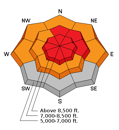
bottom line The avalanche danger remains HIGH (Level 4) above about 8,000' on all aspects, especially on slopes with recent wind deposits. Backcountry travelers should avoid all slopes steeper than 30 degrees and stay out from underneath steeper terrain. If you want steeper terrain today, and you're a skier or boarder, go to a resort where ski patrollers work hard to make the snowpack much safer.
|
 |
avalanche warning THIS AVALANCHE WARNING IS FOR THE WASATCH...BEAR RIVER AND WESTERN UINTA MOUNTAIN RANGES...THE WASATCH PLATEAU AND THE CENTRAL UTAH MOUNTAINS. HEAVY SNOW AND STRONG WINDS HAVE CREATED A HIGH AVALANCHE DANGER. HUMAN TRIGGERED AND NATURAL AVALANCHES CONTINUE TO BE LIKELY TODAY ON TERRAIN STEEPER THAN 30 DEGREES ABOVE 8000 FEET. PEOPLE SHOULD AVOID BEING ON OR BELOW ANY STEEP SNOW COVERED SLOPES UNTIL AVALANCHE CONDITIONS IMPROVE. THIS WARNING DOES NOT INCLUDE SKI AREAS OR HIGHWAYS WHERE AVALANCHE CONTROL IS NORMALLY DONE. |
 |
current conditions Wow, I absolutely LOVE a huge storm like this. I love to just stand on a ridge and TAKE IT, to feel the full fury of nature. (OK, as long as I can run back to a warm house to dry out.) We've had 1-2 feet of very heavy, dense snow with a water equivalent between 2 and 4 inches with Tony Grove Lake racking up an incredible 4.4 inches of water weight in just 16 inches of new snow. If that's not enough, the wind has been nuking from the west yesterday afternoon and overnight blowing strong enough to tip over a tractor, as we say in my native state of Montana--60 mph and gusting to near or just over 100 at some exposed stations. Several ski resorts in the Salt Lake mountains report lots of trees blown over. Yesterday afternoon, the rain snow line rose to nearly 8,000', which made very upside-down, slabby snow. Overnight, the wind dropped off a bit but it has recently ramped right back up. The 6 inches of snow that fell so far this morning has several layers of dense graupel, that Styrofoam ball type of snow. The 8,000' temperature has dropped from near freezing yesterday afternoon into the mid 20's this morning.
|
 |
recent activity No avalanches were recently reported in the Logan Zone, but there were many reports in in the Ogden, Salt Lake and Provo area mountains. Visit our Backcountry Observations Page for more information.....
|
| type | aspect/elevation | characteristics |
|---|

|
|
LIKELIHOOD
 LIKELY
UNLIKELY
SIZE
 LARGE
SMALL
TREND
 INCREASING DANGER
SAME
DECREASING DANGER
|
|
description
No sense in putting much of a fine point on it. This brick-like slab of new and wind blown snow has overloaded the very weak layer of faceted snow and fluffy new that was on the snow surface before the storm arrived. At this point, I really don't care what it's sliding on. You can expect remote trigger potential especially on slopes that face the north half of the compass. As usual, the worst problems will be on slopes with recent wind deposits. Avalanches may break 2 feet deep with a very hefty slab that will likely be more destructive than normal. (The grey areas on the rose mean no snow or very little snow.)
|
 |
weather We will continue to have another 6 inches or so of new snow today with continued high wind from the northwest, 50, gusting to 80 on the exposed peaks. Snow should slowly end by later in the day, wind will drop and the temperature will continue to fall as colder air sags into our area. On Tuesday, we may get a good day for avalanche fracture line viewing with partly cloudy skies and cool temperatures. The extended forecast is for more snow on Christmas eve and Christmas morning and mountain temperatures rising up to near freezing again. Check out our one-stop weather page........HERE
|
| general announcements You can now receive advisories by email for each region in the state including Logan. Go here for details. Get your advisory on your iPhone along with great navigation and rescue tools....... Utah Avalanche Center mobile app Please submit snow and avalanche observations from your ventures in the backcountry HERE. You can call us at 801-524-5304 or email HERE, or include #utavy in your Instagram or Tweet us @UAClogan. To report avalanche activity in the Logan Area or to contact the local avalanche forecaster call me, Toby, at 435-757-7578. I'll regularly update this advisory on Monday, Wednesday, Friday, and Saturday mornings by about 7:30. This advisory is produced by the U.S.D.A. Forest Service, which is solely responsible for its content. It describes only general avalanche conditions and local variations always exist. |


_1.jpg)
