| During the month of April, Mark Miller will donate $75 to the charity of your choice (5 to chose from, including the Utah Avalanche Center!) Mark Miller Subaru has raised over $300k in the previous 6 Do Good Feel Good events. More Info here |  |
| During the month of April, Mark Miller will donate $75 to the charity of your choice (5 to chose from, including the Utah Avalanche Center!) Mark Miller Subaru has raised over $300k in the previous 6 Do Good Feel Good events. More Info here | |
| Advisory: Logan Area Mountains | Issued by Toby Weed for Friday - December 19, 2014 - 7:07am |
|---|

|
bottom line The danger is LOW (level 1), and avalanches are unlikely on most slopes in the backcountry. Although unlikely, you still might trigger a wind slab avalanche on an isolated drifted upper elevation slope. Continue to follow safe travel protocols and practice with your rescue equipment.
|
 |
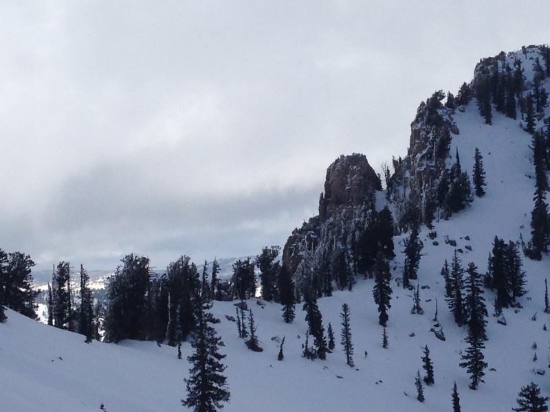
current conditions There's another inch of new snow at the 8400' Tony Grove Snotel from yesterday, with 35 inches of total snow containing 89% of average water for the date, and it's 20 degrees. The CSI Logan Peak weather station reports 14 mph southwest winds and 16 degrees. You'll find shallow fresh snow on hard crusts at lower and mid elevations, but sheltered shady slopes up high offer reasonably nice, fast shallow powder riding conditions. Upper elevation terrain in the central Bear River Range has decent coverage and mostly supportable snow. Outlying terrain like the Wellsville Range and the Front Canyons have less coverage, with access issues due to lack of lower elevation snow. The Tony Grove and Franklin Basin Roads are not maintained for wheeled travel in the winter! Decent coverage up high, but still shallow and rocky in places, like on the west ridge of Mt. Magog. (12-18-14)
|
 |
recent activity We triggered a small wind slab in Steep Hollow a week ago. No other avalanches recently reported in the Logan Zone. Visit our Backcountry Observations Page for more information.....
|
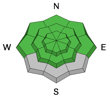
| type | aspect/elevation | characteristics |
|---|

|
|
LIKELIHOOD
 LIKELY
UNLIKELY
SIZE
 LARGE
SMALL
TREND
 INCREASING DANGER
SAME
DECREASING DANGER
|
|
description
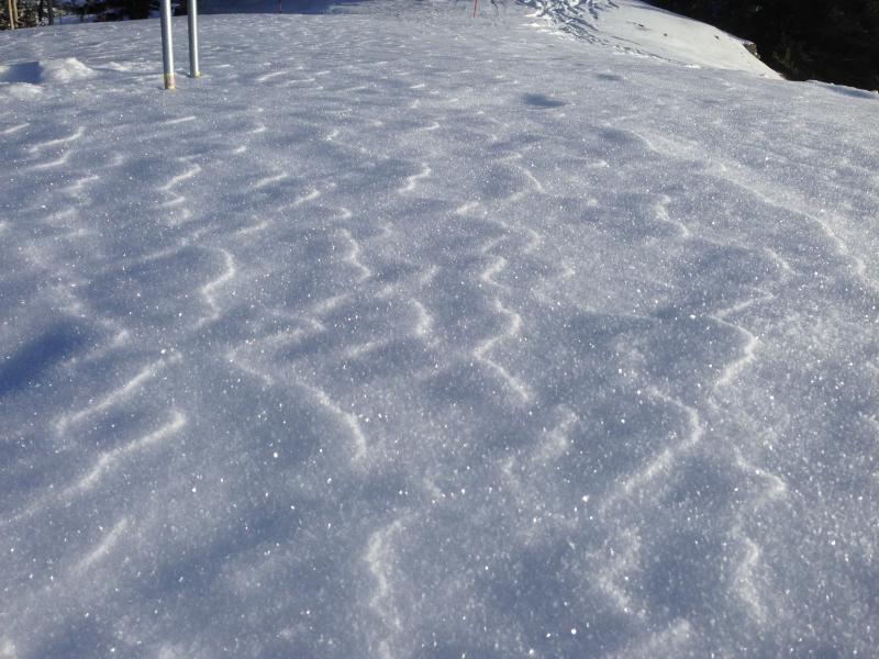
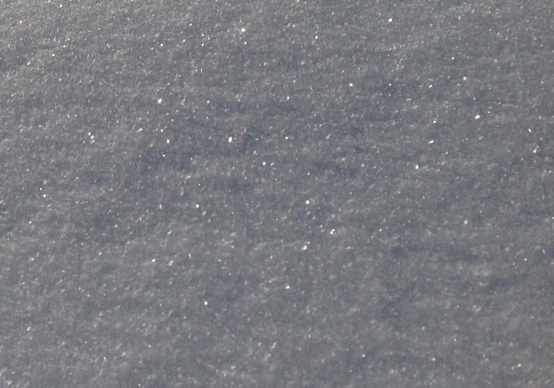
The nice shallow powder on top of the November snow is a mix of small near surface facets, surface hoar, and a bit of actual fresh powder. It's weak, and will likely be a layer that future avalanches fail on. Many avalanche paths now have stating zones that are filled in and smooth, with a hard crust capping the November snow, which could become a good bed surface. Views of glittery surface hoar or frost on the snow surface. Pretty and perhaps preserved by about an inch of fresh snow now, this could become a persistent weak layer when buried, and accumulating snow is in the forecast. (photos from 12-17-14) Although avalanches are unlikely today, you still need to practice safe travel protocols. Cross potential avalanche paths one-at-a-time while the rest of your party watches from a safer location. Everyone needs to carry a shovel, probe, and transceiver. Be sure your rescue gear is functioning by practicing with it. You can bury your pack with your transceiver in it and have your partner find, probe, and excavate it. Then get them to do the same for you. Training your team is critical in this game. +++ Quick and Easy Avalanche Rescue Practice Video............... ***HERE
|
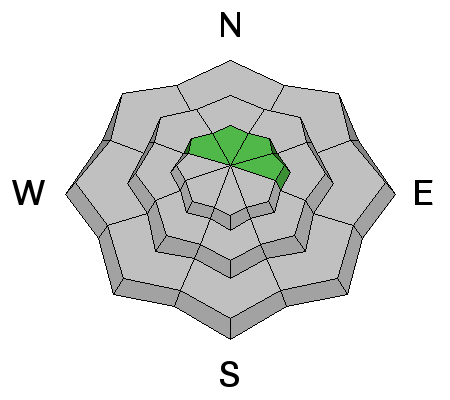
| type | aspect/elevation | characteristics |
|---|

|
|
LIKELIHOOD
LIKELY
UNLIKELY
SIZE
 LARGE
SMALL
TREND
 INCREASING DANGER
SAME
DECREASING DANGER
|
|
description
Although rather unlikely, you could trigger an isolated wind slab avalanche in upper elevation drifted terrain. In some areas, strong south winds deposited stiff snow onto soft surface snow consisting of small faceted grains. Moderate southwest winds drifting surface snow today will build fresh wind slabs, and if the wind picks up strength, fresh slab formation could occur fairly rapidly. Avoid drifted snow on steep slopes, and watch for wind slab development on the lee side of ridge-lines and in and around terrain features like gullies, scoops and cliff bands.
|
 |
weather The National Weather Service has issued a Winter Storm Watch for the mountains of Northern Utah and Southeast Idaho. Heavy snow is possible in the mountains later in the Weekend. It'll be mostly cloudy today, with 8500' high temperatures around 29 degrees and moderate southwest winds (15 mph on the ridges). There's a chance for some snow this afternoon, with an inch or so of accumulation possible. Snow is likely tonight and tomorrow, with 1 to 2 inches forecast for each 12 hr period. Snowfall should increase Saturday night and Sunday under a moist northwest flow, with more significant accumulations and heavy snow possible. There is potential for a White Christmas in the Valley, with a stronger and Cold Pacific Storm late Christmas Eve. Check out our one-stop weather page........HERE
|
| general announcements You can now receive advisories by email for each region in the state including Logan. Go here for details. Get your advisory on your iPhone along with great navigation and rescue tools....... Utah Avalanche Center mobile app Please submit snow and avalanche observations from your ventures in the backcountry HERE. You can call us at 801-524-5304 or email HERE, or include #utavy in your Instagram or Tweet us @UAClogan. To report avalanche activity in the Logan Area or to contact the local avalanche forecaster call me, Toby, at 435-757-7578. I'll regularly update this advisory on Monday, Wednesday, Friday, and Saturday mornings by about 7:30. This advisory is produced by the U.S.D.A. Forest Service, which is solely responsible for its content. It describes only general avalanche conditions and local variations always exist. |


_1.jpg)