| During the month of April, Mark Miller will donate $75 to the charity of your choice (5 to chose from, including the Utah Avalanche Center!) Mark Miller Subaru has raised over $300k in the previous 6 Do Good Feel Good events. More Info here |  |

For every car Mark MIller Subaru sells in April, they will donate $75 to the charity of your choice (5 to choose from). Who are you going to choose? Plus - you can vote for your favorite and the 3 groups receiving the most votes get an additional cash prize donated by Mark Miller Subaru. Details here

| During the month of April, Mark Miller will donate $75 to the charity of your choice (5 to chose from, including the Utah Avalanche Center!) Mark Miller Subaru has raised over $300k in the previous 6 Do Good Feel Good events. More Info here |  |
| Advisory: Logan Area Mountains | Issued by Toby Weed for Saturday - December 13, 2014 - 7:04am |
|---|
 |
current conditions The CSI Logan Peak weather station is currently reading south-southwest winds averaging a bit less than 15 mph, but overnight averages were in the 20s and 30s with 40 mph gust earlier this morning. Temperatures dropped significantly, and it's 23 degrees at 9700'. As of 4:00 this morning, there's about an inch of new snow at the 8400' Tony Grove Snotel, with 33 inches of total snow containing 105% of average water for the date. High pressure conditions have taken toll on the snow at upper elevation, weakening the snow on the surface and turning the entire snowpack to sugary non-cohesive facets in shallow areas. We're still finding good coverage at upper elevations, but the snow is less supportable around rocks and caution is certainly required, given the shallow early season conditions........ The Tony Grove and Franklin Basin Roads are not maintained for wheeled travel in the winter! In sheltered shady terrain we found some well developed and intact feathery surface hoar or frost crystals on the snow surface. (12-12-2014) Go to our Video Observation from Upper Bullen Basin on 12-10-2014..........HERE Everyone needs to carry a shovel, probe, and transceiver. Be sure your rescue gear is functioning by practicing with it, and when polite invitations don't work, force your partners to join in the fun. You can bury your pack with your transceiver in it and have your partner find, probe, and excavate it. Then get them to do the same for you. Training your team is critical in this game. Our own new, Quick and Easy Avalanche Rescue Practice Video............... ***HERE
|
 |
recent activity My partner triggered a small wind slab avalanche yesterday up in Steep Hollow at around 9500' on a drifted northeast facing slope. It was an Intentional trigger, but surprised us a bit anyway. Pretty sensitive hard thin wind slab, failed with a light stomp near ridge-top. The recently formed wind slab failed on sugary near surface facets. Report is.......... HERE Visit our Backcountry Observations Page for more information.....
|
| type | aspect/elevation | characteristics |
|---|


|


|

LIKELIHOOD
 LIKELY
UNLIKELY
SIZE
 LARGE
SMALL
TREND
 INCREASING DANGER
SAME
DECREASING DANGER
|
|
description
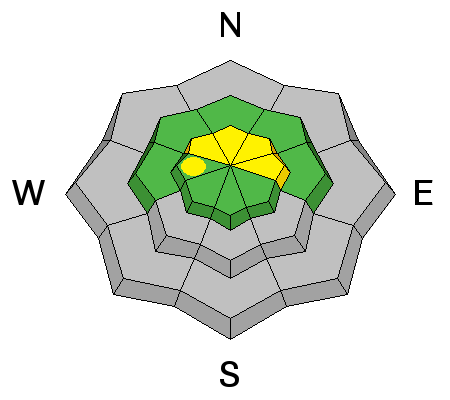
Wind slabs formed by strong south winds in the past couple days could be rather stiff, or even hard, and they might allow you to get out on them before releasing. Wind slabs are easily failing where they've built up on weak sugary surface snow. Avoid drifted snow and potential wind slabs at upper elevations on the lee side of major ridge-lines, in and around terrain features like gullies or rock outcroppings, below cliff-bands, or near cross-loaded sub-ridges. These were fairly easy to recognize yesterday; chalky looking, hollow sounding, with stiffer or even supportable snow, but may now be hidden under an inch or so of fresh snow today. Moderate westerly winds today and some accumulation will cause continued drifting in exposed terrain..
|
 |
weather Overnight accumulations in our area don't look to be all that substantial, with an inch or so in the Central Bear River Range and 3" with .6" of water at the Ben Lomond Snotel.... We'll be lucky to see another 1 or 2 inches today, with moderate westerly winds and high temperatures at 8500' around 32 degrees, but dropping in the afternoon. It'll be partly sunny tomorrow with a high temperature of around 26 degrees. High pressure conditions will return on Monday, but conditions look to be unsettled later in the week. Check out our one-stop weather page........HERE
|
| general announcements You can now receive advisories by email for each region in the state including Logan. Go here for details. Get your advisory on your iPhone along with great navigation and rescue tools....... Utah Avalanche Center mobile app Please submit snow and avalanche observations from your ventures in the backcountry HERE. You can call us at 801-524-5304 or email HERE, or include #utavy in your Instagram or Tweet us @UAClogan. To report avalanche activity in the Logan Area or to contact the local avalanche forecaster call me, Toby, at 435-757-7578. I'll regularly update this advisory on Monday, Wednesday, Friday, and Saturday mornings by about 7:30. This advisory is produced by the U.S.D.A. Forest Service, which is solely responsible for its content. It describes only general avalanche conditions and local variations always exist. |
Advisory Hotline: (888) 999-4019 | Contact Information