| During the month of April, Mark Miller will donate $75 to the charity of your choice (5 to chose from, including the Utah Avalanche Center!) Mark Miller Subaru has raised over $300k in the previous 6 Do Good Feel Good events. More Info here |  |
| During the month of April, Mark Miller will donate $75 to the charity of your choice (5 to chose from, including the Utah Avalanche Center!) Mark Miller Subaru has raised over $300k in the previous 6 Do Good Feel Good events. More Info here | |
| Advisory: Logan Area Mountains | Issued by Toby Weed for Friday - December 12, 2014 - 7:09am |
|---|

|
bottom line There's a MODERATE (level 2) danger on drifted slopes at upper elevations. Heightened avalanche conditions exist and you could trigger wind slab avalanches in some areas. Avoid drifted upper elevation slopes. Evaluate the snow and terrain carefully, and check, carry, and practice regularly with your rescue equipment. Expect a rising danger, with increasing wind and some accumulation as we head into the weekend.
|
 |
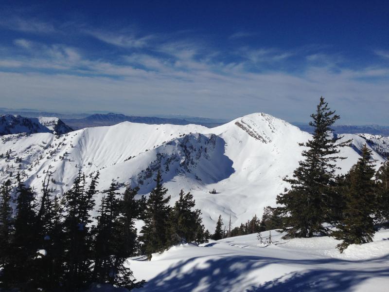
current conditions The CSI Logan Peak weather station is currently reading south winds averaging over 30 mph, with 60 mph gusts, and it's 35 degrees at 9700'. Last night the 8400' Tony Grove Snotel reported 33 inches of total snow containing 108% of average water for the date. High pressure conditions have taken toll on the snow at upper elevation, weakening the snow on the surface and turning the entire snowpack to sugary non-cohesive facets in shallow areas. We're still finding good coverage at upper elevations, but the snow is less supportable around rocks and caution is certainly required, given the shallow early season conditions........The Tony Grove road is not maintained for wheeled travel in the winter!
A view of Cherry Peak in the Mount Naomi Wilderness from the east is showing pretty good coverage up high. (12-10-2014) Go to our Video Observation from Upper Bullen Basin on 12-10-2014..........HERE Everyone needs to carry a shovel, probe, and transceiver. Be sure your rescue gear is functioning by practicing with it, and when polite invitations don't work, force your partners to join in the fun. You can bury your pack with your transceiver in it and have your partner find, probe, and excavate it. Then get them to do the same for you. Training your team is critical in this game. Our own new, Quick and Easy Avalanche Rescue Practice Video............... ***HERE
|
 |
recent activity No recent avalanches to report in the Logan Zone.... Visit our Backcountry Observations Page for details
|
| type | aspect/elevation | characteristics |
|---|

|
|
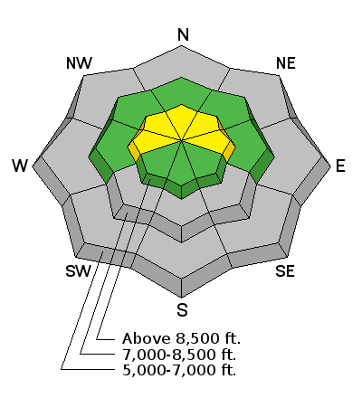
LIKELIHOOD
 LIKELY
UNLIKELY
SIZE
 LARGE
SMALL
TREND
 INCREASING DANGER
SAME
DECREASING DANGER
|
|
description
Freshly formed wind slabs could be rather stiff, or even hard, and they could allow you to get out on them before releasing. Avoid drifts and wind slabs at upper elevations. These should be fairly easy to recognize; chalky looking, hollow sounding, stiffer or even supportable snow. Increasing winds today and some accumulation tonight will cause increasing danger as we head into the weekend.
|
 |
weather It'll be partly cloudy and windy today in the mountains, with high temperatures pushing 50 degrees again at 8500' and strong south winds. A splitting storm will hopefully bring some snow to upper elevation terrain tonight and Saturday, but accumulations in our area don't look to be all that substantial.... Expect 2 to 4 inches of accumulation overnight and another 1 to 3 tomorrow, with westerly winds... Check out our one-stop weather page........HERE
|
| general announcements You can now receive advisories by email for each region in the state. Go here for details. Get your advisory on your iPhone along with great navigation and rescue tools....... Utah Avalanche Center mobile app Please submit snow and avalanche observations from your ventures in the backcountry HERE. You can call us at 801-524-5304 or email HERE, or include #utavy in your Instagram or Tweet us @UAClogan. To report avalanche activity in the Logan Area or to contact the local avalanche forecaster call me, Toby, at 435-757-7578. -I'll regularly update this advisory on Monday, Wednesday, Friday, and Saturday mornings by about 7:30. This advisory is produced by the U.S.D.A. Forest Service, which is solely responsible for its content. It describes only general avalanche conditions and local variations always exist. |


_1.jpg)