| During the month of April, Mark Miller will donate $75 to the charity of your choice (5 to chose from, including the Utah Avalanche Center!) Mark Miller Subaru has raised over $300k in the previous 6 Do Good Feel Good events. More Info here |  |
| During the month of April, Mark Miller will donate $75 to the charity of your choice (5 to chose from, including the Utah Avalanche Center!) Mark Miller Subaru has raised over $300k in the previous 6 Do Good Feel Good events. More Info here | |
| Advisory: Logan Area Mountains | Issued by Toby Weed for Saturday - December 6, 2014 - 7:09am |
|---|


|
bottom line There's a LOW (level 1) danger and the snow is stable on most slopes in the Logan Zone. Exceptions exist, especially possible loose wet avalanches on steep slopes with saturated snow. Use normal caution, continue to use safe travel protocols, and check, carry, and practice regularly with your rescue equipment.
|
 |
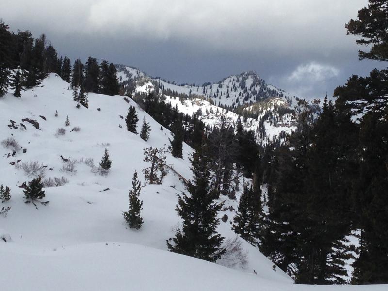
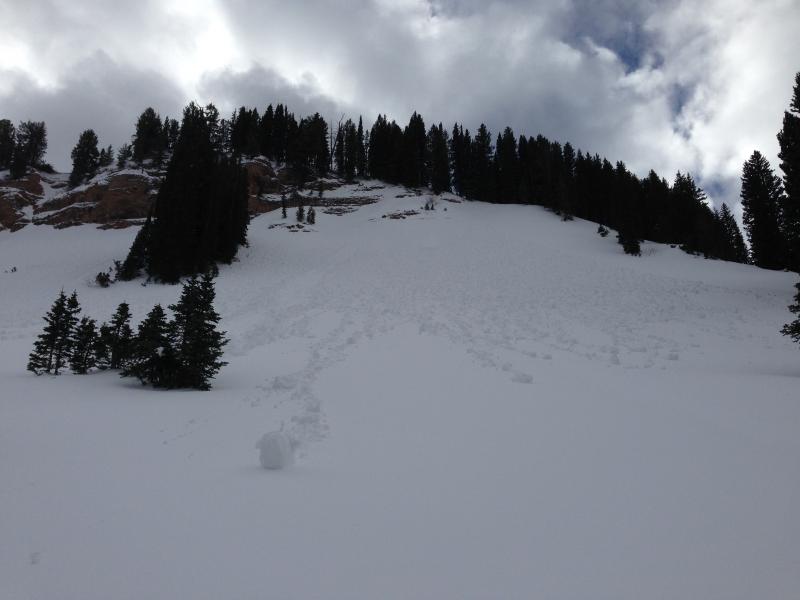
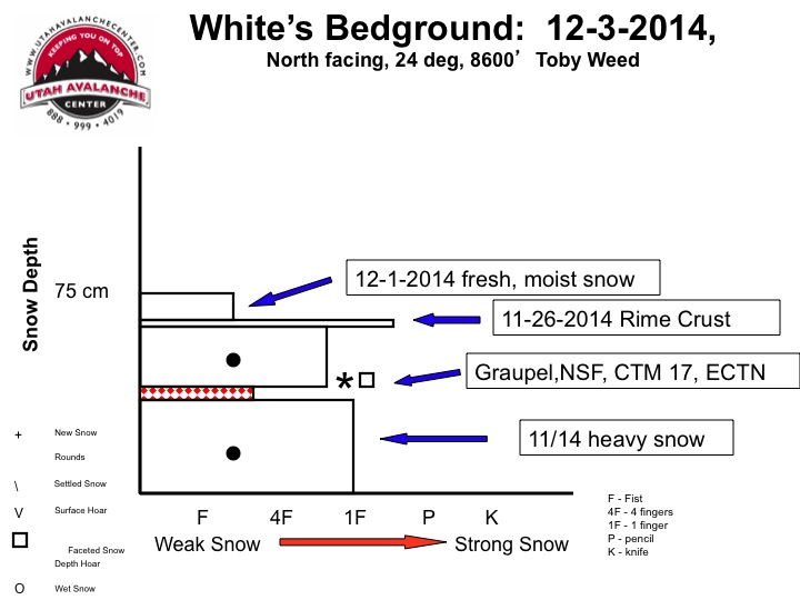
current conditions This morning at the 8400' Tony Grove Snotel, it's 32 degrees and there's an inch of new snow, and 36 inches of total snow containing 136% of average water for the date. The 9700' CSI Logan Peak weather station is recording south winds, currently averaging a bit less than 20 mph. The coverage is quite good above around 8000', with the heavy snows from November nicely filling in the rocky terrain. You can ride just about anywhere without sinking in too deeply and you can see the larger protruding rocks, but I found ascending on skis difficult in places because of a slippery rime-crust beneath a few inches of mashed potato-like snow. The snow got pretty moist even at upper elevations yesterday, and we observed both natural and triggered surface sluffs and extensive roller balling in steep terrain. ***Here's my Video Observation from the White's Bedground Area on Wednesday.
Very good coverage for early December in the Bear River Range. Mt. Magog from the South. (12-5-2014) Be sure your rescue gear is functioning by practicing with it, and force your partners to join in. It is they who will be your best bet for survival if you get caught in an avalanche. The Tony Grove road is not maintained for wheeled travel in the winter!
|
 |
recent activity No recent avalanches to report in the Logan Zone.... Visit our Backcountry Observations Page for details
|
| type | aspect/elevation | characteristics |
|---|

|
|
LIKELIHOOD
 LIKELY
UNLIKELY
SIZE
 LARGE
SMALL
TREND
 INCREASING DANGER
SAME
DECREASING DANGER
|
|
description
Although certainly not widespread, pockets with heightened avalanche conditions exist, and triggered avalanches are possible in some upper elevation terrain. Loose wet avalanches are possible on steep slopes with saturated surface snow, especially during the heat of midday... Be aware of and avoid steep slopes with terrain traps or trees below.
Extensive natural roller balls and a small wet sluff in west Miller Bowl. (12-5-2014) There may be very steep isolated slopes on the highest peaks where one could trigger a deeper persistent slab avalanche. Avoid deposits of drifted snow on the lee side of major ridges and areas where snow has been deposited into gullies or below cliff bands by strong winds.
|
 |
weather It'll be mostly cloudy, with a 20% chance of snow and a high temperature at 8500' of 38 degrees and a westerly breeze. It'll be partly sunny tomorrow, with temperatures again in the upper 30s and light southwest winds. Similar weather conditions will persist through most of next week, with only a hint of a pattern change and the next Pacific storm and a deep trough of Low Pressure at the extent of the forecast period and a week or so out.... Check out our one-stop weather page........HERE
|
| general announcements Big THANKS to our support and to YOU for coming to our Pray for Snow fundraiser. You made the party a huge success! Backcountry 101 Avalanche Class! Register now for our first on-snow class of the season. Thursday evening December 11 and all day Saturday December 13. http://utahavalanchecenter.org/classes/backcountry-101-4 You can now receive advisories by email for each region in the state. Go here for details. Get your advisory on your iPhone along with great navigation and rescue tools....... Utah Avalanche Center mobile app Please submit snow and avalanche observations from your ventures in the backcountry HERE. You can call us at 801-524-5304 or email HERE, or include #utavy in your Instagram or Tweet us @UAClogan . To report avalanche activity in the Logan Area or to contact the local avalanche forecaster call me, Toby, at 435-757-7578. I'll regularly update this advisory on Monday, Wednesday, Friday, and Saturday mornings by about 7:30. This advisory is produced by the U.S.D.A. Forest Service, which is solely responsible for its content. It describes only general avalanche conditions and local variations always exist. |


_1.jpg)