| During the month of April, Mark Miller will donate $75 to the charity of your choice (5 to chose from, including the Utah Avalanche Center!) Mark Miller Subaru has raised over $300k in the previous 6 Do Good Feel Good events. More Info here |  |
| During the month of April, Mark Miller will donate $75 to the charity of your choice (5 to chose from, including the Utah Avalanche Center!) Mark Miller Subaru has raised over $300k in the previous 6 Do Good Feel Good events. More Info here | |
| Advisory: Logan Area Mountains | Issued by Toby Weed for Saturday - November 29, 2014 - 6:55am |
|---|

|
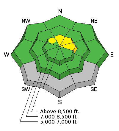
bottom line There's a LOW (level 1) danger and the snow is generally stable on most slopes in the Logan Zone. Exceptions, heightened avalanche conditions, and a MODERATE or level 2 danger exist on isolated drifted slopes at upper elevation. Evaluate the snow and terrain carefully, continue to use safe travel protocols, and practice regularly with your rescue equipment.
|
 |
special announcement We look forward to seeing you at our annual fundraiser party at the Italian Place in Logan on Wednesday evening, December 3... We very much need and value your support.
|
 |
current conditions There's 34 inches of total snow this morning at the 8400' Tony Grove Snotel. It's 28 degrees at 9700', and the CSI Logan Peak weather station is recording southwest winds averaging in the upper twenties. We're seeing fairly good stability locally. Perhaps we're lucky not to have had any snow on the ground in early November. Upper elevation slopes in the Central Bear River Range now have 3 to 4 feet of snow where there was none before the 11/14 storm. The snow is saturated at mid and lower elevations and crusts will develop in most areas with cooling this weekend. The Tony Grove road is not maintained for wheeled travel in the winter!
|
 |
recent activity No avalanches were recently reported in the Logan Zone, but it's still active and dangerous in the Central Wasatch Range. Visit our Backcountry Observations Page for details
|
| type | aspect/elevation | characteristics |
|---|

|
|
LIKELIHOOD
 LIKELY
UNLIKELY
SIZE
 LARGE
SMALL
TREND
 INCREASING DANGER
SAME
DECREASING DANGER
|
|
description
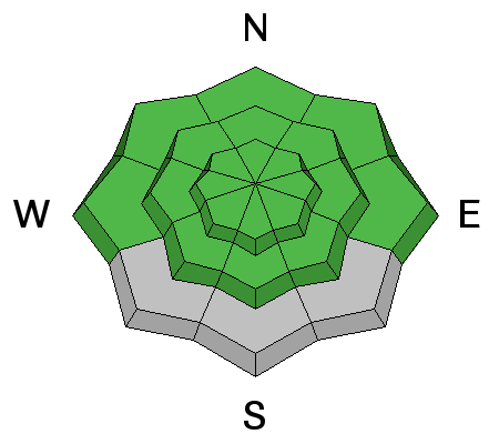
Heightened wet avalanche conditions may still exist on steep slopes with saturated snow, and loose wet avalanches or sluffs are possible. Head for lower angled terrain if you find soft or punchy conditions. Avoid steep slopes above terrain traps like trees or gullies.. Be sure your rescue gear is functioning by practicing with it, and force your partners to join in. It is they who will be your best bet for survival if you get caught in an avalanche. |
| type | aspect/elevation | characteristics |
|---|

|
|
LIKELIHOOD
LIKELY
UNLIKELY
SIZE
 LARGE
SMALL
TREND
 INCREASING DANGER
SAME
DECREASING DANGER
|
|
description
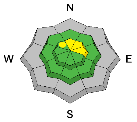
Triggered wind slab avalanches are possible in isolated exposed upper elevation terrain. Very steep slopes on the highest peaks are suspect. Avoid recent deposits of drifted snow on the lee side of major ridges and areas where snow has been deposited into gullies of below cliff bands by the recent strong winds. Fresh accumulations will be quickly drifted by strong westerly winds today, and more than expected snowfall will create larger fresh wind slabs and more dangerous conditions.
|
 |
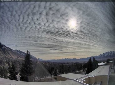
weather The National Weather Service in Pocatello has issued a Winter Weather Advisory for the mountains north of the state line. It'll be windy again today in the mountains, with partly sunny skies this morning and a high forecast high temperature of 42 degrees at 8500' and 20-30 mph southwest winds, with gusts near 50 mph in some exposed areas. Snow is likely but accumulations look light, and we'd be lucky to see 1 to 2 inches of accumulation today and tonight. Snow showers should continue on and off through Monday. Check out our one-stop weather page........HERE USU Wx Cam view of clouds yesterday,(11-28-2014) |
| general announcements Don't forget our annual fundraiser party at the Italian Place in Logan on Wednesday evening, December 3... Backcountry 101 Avalanche Class coming up! Register now for our first on-snow class of the season. Thursday evening December 11 and all day Saturday December 13. The season is upon us and the time is now to learn how to stay safe in the backcountry. http://utahavalanchecenter.org/classes/backcountry-101-4 NEW THIS YEAR: You can now receive advisories by email for each region in the state. Go here for details. Utah Avalanche Center mobile app - Get your advisory on your iPhone along with great navigation and rescue tools. Remember your information can save lives. If you see anything we should know about, please participate in the creation of our own community avalanche advisory by submitting snow and avalanche conditions. You can also call us at 801-524-5304 or 800-662-4140, email by clicking HERE, or include #utavy in your Instagram. Follow us at UAClogan on Twitter This advisory is produced by the U.S.D.A. Forest Service, which is solely responsible for its content. It describes only general avalanche conditions and local variations always exist. |


_1.jpg)