| During the month of April, Mark Miller will donate $75 to the charity of your choice (5 to chose from, including the Utah Avalanche Center!) Mark Miller Subaru has raised over $300k in the previous 6 Do Good Feel Good events. More Info here |  |
| During the month of April, Mark Miller will donate $75 to the charity of your choice (5 to chose from, including the Utah Avalanche Center!) Mark Miller Subaru has raised over $300k in the previous 6 Do Good Feel Good events. More Info here | |
| Advisory: Logan Area Mountains | Issued by Toby Weed for Wednesday - November 26, 2014 - 7:14am |
|---|

|
bottom line Heightened avalanche conditions exist in the backcountry, and there's a MODERATE or level 2 danger. You might trigger wind slab avalanches on some steep drifted upper elevation slopes. The danger of triggered loose wet avalanches will rise with temperatures today in saturated snow at lower and mid elevations. Evaluate the snow and terrain carefully, continue to use safe travel protocols, and practice regularly with your rescue equipment.
|
 |
special announcement We look forward to seeing you at our annual fundraiser party at the Italian Place in Logan on Wednesday evening, December 3...
|
 |
current conditions There's 40 inches of total snow this morning, containing 176% of average water for the date, and a temperature of 32 degrees at the 8400' Tony Grove Snotel. The station reports only a couple inches of new snow containing 1.3 inches of water in the last 24 hrs. The wind sensor at the CSI weather station on Logan Peak must be rimed, but southwest winds are currently averaging in the mid thirties with gusts in the 40's on Mt Ogden. It's also fairly windy at the Hwy 89 Logan Summit weather station, with northwest winds gusting into the 40 mph range and it's 36 degrees
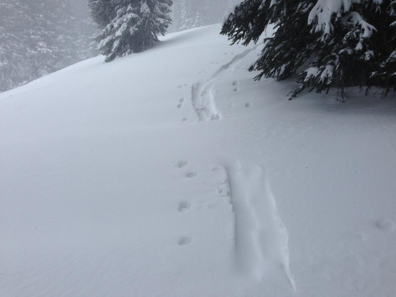
Our tracks were rapidly filling in with heavy drifting snow yesterday. (11-25-2014) We verified the big snow and water readings up at the Tony Grove Snotel yesterday, and we found excellent coverage and good stability on the slopes above the campground. Upper elevation slopes in the Central Bear River Range now have 3 to 4 feet of snow where there was none a week-and-a-half ago (before 11/14). We floated in the top couple inches of heavy new snow yesterday on skis and sled, but would sink up to the hip in just boots. The Tony Grove road is not maintained for wheeled travel in the winter!
|
 |
recent activity No avalanches were yet reported this season in the Logan Zone, but it was very active in the Central Wasatch Range during and since the weekend storm. Visit our Backcountry Observations Page for details
|
| type | aspect/elevation | characteristics |
|---|

|
|
LIKELIHOOD
 LIKELY
UNLIKELY
SIZE
 LARGE
SMALL
TREND
 INCREASING DANGER
SAME
DECREASING DANGER
|
|
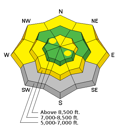
description
Triggered wind slab avalanches are possible in exposed upper elevation terrain this morning. We did not find any sensitive wind slabs yesterday, and it seemed like the heavy rimed snow was being molded in place by the strong wind. But, we also noted extensive drifting, and steep slopes on the highest peaks are certainly suspect. Avoid drifted snow on the lee side of major ridges and areas where fresh snow has been deposited into gullies of below cliff bands by the strong winds. |
| type | aspect/elevation | characteristics |
|---|

|
|
LIKELIHOOD
LIKELY
UNLIKELY
SIZE
LARGE
SMALL
TREND
 INCREASING DANGER
SAME
DECREASING DANGER
|
|
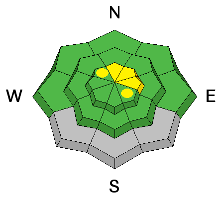
description
Warming temperatures today will create heightened avalanche conditions on steep slopes at lower elevations, and loose wet avalanches are possible in the snow already saturated by rain from yesterday afternoon and evening.
|
 |
weather It'll be windy and warm today in the mountains, with partly sunny skies and a high forecast high temperature of 42 degrees at 8500' and 20-30 mph west winds, with gusts near 50 mph in some exposed areas. It'll be even warmer and a bit less windy on Thanksgiving Day, with high a temperature of 45 degrees and a southwest breeze. The next chance for powder comes over the weekend, but it dosn't look like we'll see much accumulation. We should remain in an active pattern next week Check out our one-stop weather page........HERE |
| general announcements Don't forget our annual fundraiser party at the Italian Place in Logan on Wednesday evening, December 3... Backcountry 101 Avalanche Class coming up! Register now for our first on-snow class of the season. Thursday evening December 11 and all day Saturday December 13. The season is upon us and the time is now to learn how to stay safe in the backcountry. http://utahavalanchecenter.org/classes/backcountry-101-4 NEW THIS YEAR: You can now receive advisories by email for each region in the state. Go here for details. Utah Avalanche Center mobile app - Get your advisory on your iPhone along with great navigation and rescue tools. Remember your information can save lives. If you see anything we should know about, please participate in the creation of our own community avalanche advisory by submitting snow and avalanche conditions. You can also call us at 801-524-5304 or 800-662-4140, email by clicking HERE, or include #utavy in your Instagram. Follow us at UAClogan on Twitter This advisory is produced by the U.S.D.A. Forest Service, which is solely responsible for its content. It describes only general avalanche conditions and local variations always exist. |


_1.jpg)