| During the month of April, Mark Miller will donate $75 to the charity of your choice (5 to chose from, including the Utah Avalanche Center!) Mark Miller Subaru has raised over $300k in the previous 6 Do Good Feel Good events. More Info here |  |
| During the month of April, Mark Miller will donate $75 to the charity of your choice (5 to chose from, including the Utah Avalanche Center!) Mark Miller Subaru has raised over $300k in the previous 6 Do Good Feel Good events. More Info here | |
| Advisory: Logan Area Mountains | Issued by Toby Weed for Saturday - November 22, 2014 - 7:15am |
|---|

|
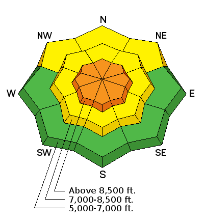
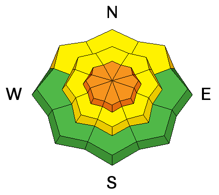
bottom line There is a MODERATE or level 2 danger in the backcountry this morning, with triggered wind slab avalanches possible at upper elevations. The danger will rise significantly with a strong Pacific storm today. Heavy snowfall and continuing strong winds from this will likely create dangerous avalanche conditions and a CONSIDERABLE or level 3 danger at upper elevations. Especially as the new snow piles up, we should avoid steep drifted slopes at upper elevations..
|
 |
avalanche warning THIS AVALANCHE WARNING IS FOR ALL MOUNTAINS OF NORTHERN UTAH. DANGEROUS AVALANCHE CONDITIONS WILL DEVELOP BY THIS AFTERNOON AS STRONG WINDS AND HEAVY SNOW OVERLOAD THE PREEXISTING WEAK SNOW ON THE GROUND. THIS AVALANCHE WARNING IS FROM 3 PM THIS AFTERNOON THROUGH 5 PM MONDAY. THIS WARNING DOES NOT INCLUDE SKI AREAS OR HIGHWAYS WHERE AVALANCHE CONTROL IS NORMALLY DONE. |
 |
special announcement We look forward to seeing you at our annual fundraiser party at the Italian Place in Logan on December 3...
|
 |
current conditions There's 20 inches of total snow this morning, containing 105% of average water for the date, and a temperature of 32 degrees at the 8400' Tony Grove Snotel. South winds are currently averaging around 38 mph at 9700' on Logan Peak, and the CSI Logan Peak Weather station reports 25 degrees Last weekend's snow is showing the effects of a strong temperature gradient and resulting sublimation, and its starting to get a bit weak and sugary. Frost or surface hoar crystals are also starting to show up in some lower and mid elevation areas. The Tony Grove road is not maintained for wheeled travel in the winter, and I'm not sure if you can get up anywhere near the lake. You can find good road and and open meadow riding up high, but remember the snow you see is all we have, there's no base!
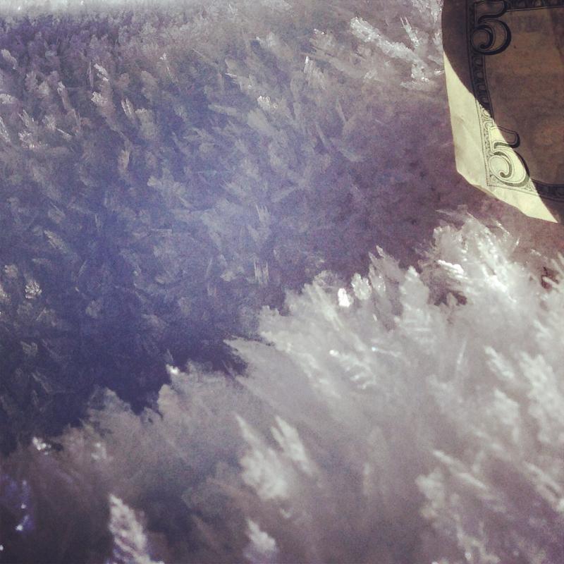
Feathers of Surface Hoar or frost like these in Wood Camp Hollow can become a persistent weak layer if buried intact.
|
 |
recent activity No avalanches were yet reported this season in the Logan Zone, but it was active in the Wasatch last weekend. Visit our Backcountry Observations Page for details
|
| type | aspect/elevation | characteristics |
|---|

|
|
LIKELIHOOD
 LIKELY
UNLIKELY
SIZE
 LARGE
SMALL
TREND
 INCREASING DANGER
SAME
DECREASING DANGER
|
|
description
Triggered wind slab avalanches are possible in exposed terrain this morning. Strong and increasing south winds overnight built hard wind slabs in terrain features and near ridge lines. Expect the danger of wind slabs to rise significantly today, especially during periods of heavy snowfall and continuing strong winds... |
| type | aspect/elevation | characteristics |
|---|

|
|
LIKELIHOOD
 LIKELY
UNLIKELY
SIZE
LARGE
SMALL
TREND
INCREASING DANGER
SAME
DECREASING DANGER
|
|
description
Today's storm with Heavy snow and strong winds will cause rapid accumulations on preexisting weak snow. The new snow will not probably not stick so well to the our current snow surface consisting of sugary faceted snow and feathery surface hoar in places. The avalanche danger will rise quickly this afternoon at upper elevations and dangerous storm slab avalanche conditions are likely to develop on many steep slopes. |
 |
weather The National Weather Service has issued a Winter Storm Warning for the Logan Zone today. Expect increasing avalanche danger with strong and increasing southwest winds and heavy snowfall, and around a foot of accumulation possible during the day today Snowfall should continue tonight through Sunday, and intensify again Sunday night with another foot or so possible then. Check out our one-stop weather page........HERE |
| general announcements NEW THIS YEAR: You can now receive advisories by email for each region in the state. Go here for details. Utah Avalanche Center mobile app - Get your advisory on your iPhone along with great navigation and rescue tools. Remember your information can save lives. If you see anything we should know about, please participate in the creation of our own community avalanche advisory by submitting snow and avalanche conditions. You can also call us at 801-524-5304 or 800-662-4140, email by clicking HERE, or include #utavy in your tweet or Instagram. Follow us at UAClogan on Twitter This advisory is produced by the U.S.D.A. Forest Service, which is solely responsible for its content. It describes only general avalanche conditions and local variations always exist. |


_1.jpg)