
| During the month of April, Mark Miller will donate $75 to the charity of your choice (5 to chose from, including the Utah Avalanche Center!) Mark Miller Subaru has raised over $300k in the previous 6 Do Good Feel Good events. More Info here |  |
| During the month of April, Mark Miller will donate $75 to the charity of your choice (5 to chose from, including the Utah Avalanche Center!) Mark Miller Subaru has raised over $300k in the previous 6 Do Good Feel Good events. More Info here | |
| Advisory: Logan Area Mountains | Issued by Toby Weed for Thursday - April 24, 2014 - 7:06am |
|---|

|
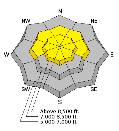
bottom line Sustained southwest winds drifted Tuesday's fresh snow into shallow wind slabs and built-out cornices, creating pockets of MODERATE or level 2 danger on a few upper elevation slopes. You could trigger shallow wind slab avalanches in steep drifted terrain. Seasonal warming will cause heightened avalanche conditions and a MODERATE danger of triggered loose wet avalanches entraining the fresh snow. Evaluate the snow and terrain carefully.
|
 |
current conditions It's 28 degrees this morning up at the 8400' Tony Grove Lake Snotel, and there's 5 inches of new snow from Tuesday, with 83 inches of total snow containing 126% of average water for the date. It's 20 degrees at the 9700' CSI Logan Peak weather station, with southwest winds averaging around 25 mph. I found nice shallow powder conditions yesterday in Providence Canyon, with 4 or 5 inches of new snow on smooth and supportable refrozen snow. The coverage is excellent for this time of year in the Logan Area Mountains.
A view of the Wellsville Range from across Catch Valley showing excellent coverage for this time of year. 4-23-2014
|
 |
recent activity There have not been any new avalanches reported recently in the Logan Zone since the very warm and active spell earlier in April. Visit our Backcountry Observations Page for details on the season's activity.
|
| type | aspect/elevation | characteristics |
|---|

|
|
LIKELIHOOD
 LIKELY
UNLIKELY
SIZE
 LARGE
SMALL
TREND
 INCREASING DANGER
SAME
DECREASING DANGER
|
|
description
As the fresh snow warms, it'll get moist and more cohesive, and loose wet avalanches entraining the fresh snow will become more likely in steep terrain. |
| type | aspect/elevation | characteristics |
|---|

|
|
LIKELIHOOD
LIKELY
UNLIKELY
SIZE
 LARGE
SMALL
TREND
 INCREASING DANGER
SAME
DECREASING DANGER
|
|
description
Southwest winds overnight and this morning continued to form shallow wind slabs and build out cornices at upper elevations. You could trigger shallow wind slabs at upper elevations in some steep drifted terrain, and you should continue to avoid and stay out from under cornices, which might break further back than you expect and could trigger avalanches on slopes below.
|
 |
weather Check out our one-stop weather page........HERE |
| general announcements Utah Avalanche Center mobile app - Get your advisory on your iPhone along with great navigation and rescue tools. Remember your information can save lives. If you see anything we should know about, please participate in the creation of our own community avalanche advisory by submitting snow and avalanche conditions. You can also call us at 801-524-5304 or 800-662-4140, email by clicking HERE, or include #utavy in your tweet or Instagram. Follow us at UAClogan on Twitter I'll issue weekend and intermittent advisories through April. This advisory is produced by the U.S.D.A. Forest Service, which is solely responsible for its content. It describes only general avalanche conditions and local variations always exist. |


_1.jpg)


