| During the month of April, Mark Miller will donate $75 to the charity of your choice (5 to chose from, including the Utah Avalanche Center!) Mark Miller Subaru has raised over $300k in the previous 6 Do Good Feel Good events. More Info here |  |
| During the month of April, Mark Miller will donate $75 to the charity of your choice (5 to chose from, including the Utah Avalanche Center!) Mark Miller Subaru has raised over $300k in the previous 6 Do Good Feel Good events. More Info here | |
| Advisory: Logan Area Mountains | Issued by Toby Weed for Sunday - April 13, 2014 - 7:23am |
|---|

|
bottom line Freezing overnight temperatures helped to solidify the saturated snow. But recent hot weather has created heightened avalanche conditions, and there's still a MODERATE or level 2 danger in the backcountry. Wet avalanches and large cornice-falls are possible in steep terrain, especially during the heat of midday. Evaluate the snow and terrain carefully.
|
 |
current conditions The Tony Grove Snotel at 8400' reports 95 inches of total snow, with 136% of average water content for the date. It's nice and cold this morning at the 9700' CSI Logan Peak weather station, with 19 degrees and west winds averaging around 10 mph.
|
 |
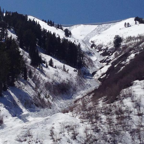
recent activity There were numerous natural wet and a few large avalanches across the mountains of northern Utah during the recent hot weather. Locally: There were a few large natural wet avalanches during the warm spell, with most of the activity on Thursday and Friday. Visit our Backcountry Observations Page for details on the season's activity.
A large natural wet avalanche from the warm spell in North Hells Canyon in the Wellsville Mountain Wilderness. The avalanche was triggered by cornice-fall and ran around 2000 vertical feet. 4-11-2014.
|
| type | aspect/elevation | characteristics |
|---|

|

|
LIKELIHOOD
 LIKELY
UNLIKELY
SIZE
 LARGE
SMALL
TREND
 INCREASING DANGER
SAME
DECREASING DANGER
|
description
|
| type | aspect/elevation | characteristics |
|---|

|
|
LIKELIHOOD
 LIKELY
UNLIKELY
SIZE
LARGE
SMALL
TREND
INCREASING DANGER
SAME
DECREASING DANGER
|
|
description
Avoid and stay out from under large and overhanging cornices along major ridge-lines, which are likely to break further back than you expect and could trigger avalanches on slopes below. It's especially important to stay out from under these guys during the heat of the day, when they sag and buckle, and more will likely naturally fail and calve off in large chunks.
|
 |
weather Check out our one-stop weather page........HERE |
| general announcements Utah Avalanche Center mobile app - Get your advisory on your iPhone along with great navigation and rescue tools. Remember your information can save lives. If you see anything we should know about, please participate in the creation of our own community avalanche advisory by submitting snow and avalanche conditions. You can also call us at 801-524-5304 or 800-662-4140, email by clicking HERE, or include #utavy in your tweet or Instagram. Follow us at UAClogan on Twitter I'll issue weekend and intermittent advisories through April. This advisory is produced by the U.S.D.A. Forest Service, which is solely responsible for its content. It describes only general avalanche conditions and local variations always exist. |


_1.jpg)