
| During the month of April, Mark Miller will donate $75 to the charity of your choice (5 to chose from, including the Utah Avalanche Center!) Mark Miller Subaru has raised over $300k in the previous 6 Do Good Feel Good events. More Info here |  |
| During the month of April, Mark Miller will donate $75 to the charity of your choice (5 to chose from, including the Utah Avalanche Center!) Mark Miller Subaru has raised over $300k in the previous 6 Do Good Feel Good events. More Info here | |
| Advisory: Logan Area Mountains | Issued by Toby Weed for Friday - April 4, 2014 - 5:47am |
|---|

|
bottom line Heightened avalanche conditions exist in the backcountry, and there's a MODERATE or level 2 danger in some drifted upper elevation terrain. Triggered cornice falls and wind slab avalanches are possible. Wet avalanches will become more likely during the warmth of midday if the fresh snow is warmed and becomes saturated. Evaluate the snow and terrain carefully
|
 |
special announcement
Sale on all remaining discount lift tickets donated to the Utah Avalanche Center from Beaver Mountain, Wolf Mountain, Sundance, and Brian Head: The few remaining tickets are being blown out with all proceeds used to pay for avalanche advisories and education. Go here to get your tickets.
|
 |
current conditions The Tony Grove Snotel at 8400' reports 112 inches of total snow, with 133% of average water content for the date. It's 17 degrees at the 9700' CSI Logan Peak weather station, and I'm currently reading 15 mph south winds. You'll find nice powder riding across the zone, but also heightened avalanche conditions on some steep slopes with significant deposits of new and drifted snow. Increasing cloud cover and good ventilation should keep a lid on warming today, but seasonal midday warming may create a danger of wet or heat-related avalanches.
|
 |
recent activity Observers on Wednesday spotted a small natural wind slab release in the Goalpost area in Upper Dry Canyon. Another party explored the main Wood Camp Area, where a previously unreported huge natural avalanche from the extensive February cycle filled-in the the flats in the giant central run-out zone. Visit our Backcountry Observations Page for details on the season's activity.
|
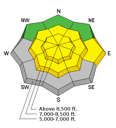
| type | aspect/elevation | characteristics |
|---|

|
|
LIKELIHOOD
 LIKELY
UNLIKELY
SIZE
 LARGE
SMALL
TREND
 INCREASING DANGER
SAME
DECREASING DANGER
|
description
|
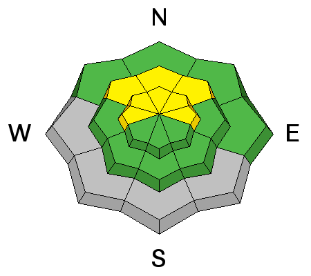
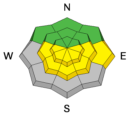
| type | aspect/elevation | characteristics |
|---|

|
|
LIKELIHOOD
LIKELY
UNLIKELY
SIZE
LARGE
SMALL
TREND
 INCREASING DANGER
SAME
DECREASING DANGER
|
|
description
It's not supposed to get too warm today, but you have to suspect seasonal warming this time of year. Avoid steep slopes with saturated surface snow.
|
 |
weather
Check out our one-stop weather page........HERE |
| general announcements Utah Avalanche Center mobile app - Get your advisory on your iPhone along with great navigation and rescue tools. Remember your information can save lives. If you see anything we should know about, please participate in the creation of our own community avalanche advisory by submitting snow and avalanche conditions. You can also call us at 801-524-5304 or 800-662-4140, email by clicking HERE, or include #utavy in your tweet or Instagram. Follow us at UAClogan on Twitter I'll issue weekend and intermittent advisories through April. This advisory is produced by the U.S.D.A. Forest Service, which is solely responsible for its content. It describes only general avalanche conditions and local variations always exist. |


_1.jpg)


