| During the month of April, Mark Miller will donate $75 to the charity of your choice (5 to chose from, including the Utah Avalanche Center!) Mark Miller Subaru has raised over $300k in the previous 6 Do Good Feel Good events. More Info here |  |
| During the month of April, Mark Miller will donate $75 to the charity of your choice (5 to chose from, including the Utah Avalanche Center!) Mark Miller Subaru has raised over $300k in the previous 6 Do Good Feel Good events. More Info here | |
| Advisory: Logan Area Mountains | Issued by Toby Weed for Monday - March 31, 2014 - 6:39am |
|---|

|
bottom line Dangerous avalanche conditions exist in the backcountry, and there's a CONSIDERABLE or level 3 danger in some drifted upper and mid-elevation terrain. Triggered cornice falls, wind slabs, and persistent slab avalanches are likely, and some natural activity is possible. Wet avalanches will become more likely during the warmth of midday as the fresh snow becomes saturated. Careful snowpack evaluation, cautious route-finding, and conservative decision making will be essential for safe travel in the backcountry.
|
 |
special announcement
Sale on all remaining discount lift tickets donated to the Utah Avalanche Center from Beaver Mountain, Wolf Mountain, Sundance, and Brian Head: The few remaining tickets are being blown out with all proceeds used to pay for avalanche advisories and education. Go here to get your tickets.
|
 |
current conditions The Tony Grove Snotel at 8400' reports 13 inches of settled new snow in the last 24 hours, containing 1.6 inches of water. There's 117 inches of total snow, with 134% of average water content for the date. It's only 14 degrees at the 9700' CSI Logan Peak weather station, and I'm currently reading light west winds, significantly diminished since early yesterday. You'll find nice powder riding across the zone, but also dangerous avalanche conditions on steep slopes with significant deposits of new and drifted snow.
|
 |
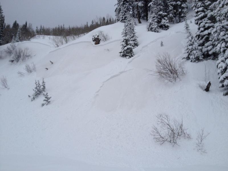
recent activity We've received daily reports of people being caught and carried by avalanches in the Central Wasatch Backcountry since Thursday, and yet another yesterday. No injuries were yet reported. In the Logan Zone, no one has been caught, but several natural and intentionally triggered avalanches were reported in the last few days. Visit our Backcountry Observations Page for details on the season's activity.
These shallow, intentionally triggered wind slabs ran late Thursday on the warm dusty snow that was on the surface for much of March. This interface is suspect again today, but now a couple storms worth of snow will be involved and avalanches will be larger and probably not so manageable.
|
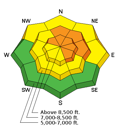
| type | aspect/elevation | characteristics |
|---|

|
|
LIKELIHOOD
 LIKELY
UNLIKELY
SIZE
 LARGE
SMALL
TREND
 INCREASING DANGER
SAME
DECREASING DANGER
|
description
|
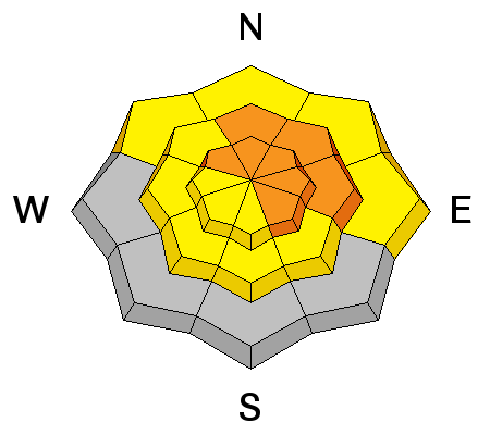
| type | aspect/elevation | characteristics |
|---|

|
|
LIKELIHOOD
LIKELY
UNLIKELY
SIZE
LARGE
SMALL
TREND
 INCREASING DANGER
SAME
DECREASING DANGER
|
|
description
Avalanches could step down just below dusty warm snow that was on the surface for during the Mid-March warm spell. In many cases, this interface between last week's snow and the older March melt-freeze snow appears weak, with the dusty layer at or perhaps just above a potential bed surface. In some cases, a thin layer consisting of small-grained sugary facets likely developed due to the strong temperature gradient right at this interface. Avalanches including Thursday's and the weekend's snow could be 1 to 2 feet deep, and they could be fairly wide, failing as well connected slabs on some slopes.
|
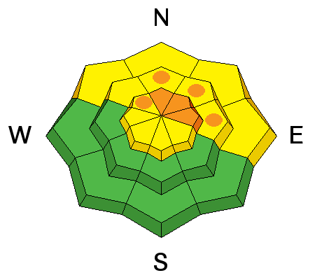
| type | aspect/elevation | characteristics |
|---|

|
|
LIKELIHOOD
 LIKELY
UNLIKELY
SIZE
LARGE
SMALL
TREND
 INCREASING DANGER
SAME
DECREASING DANGER
|
|
description
It's not supposed to get too warm today, but you have to suspect seasonal warming this time of year anytime there is significant fresh snow. It won't take much warming to dampen the new snow, and as it is initially warmed, loose wet avalanches will become likely in steep terrain. Natural avalanches are also possible with seasonal warming, as the fresh snow becomes damp and more cohesive. If the sun peaks out from behind cloud-cover, the snow could go from nice powder to a cohesive and volatile moist layer almost instantly.
|
 |
weather Should stay mostly cloudy today, some snow showers are possible with a high temperature at 8500' around 30 degrees and light west winds this morning becoming calm in the afternoon. Snow showers are likly tonight, with temperatures in the mid twenties and light south winds. Snow is likely again tomorrow, with 2 to 4 inches of accumulation forecast, with east-southeast winds in the morning switching to southwest in the afternoon. Unsettled and moist weather will continue through much of the week Check out our one-stop weather page........HERE |
| general announcements Utah Avalanche Center mobile app - Get your advisory on your iPhone along with great navigation and rescue tools. Remember your information can save lives. If you see anything we should know about, please participate in the creation of our own community avalanche advisory by submitting snow and avalanche conditions. You can also call us at 801-524-5304 or 800-662-4140, email by clicking HERE, or include #utavy in your tweet or Instagram. Follow us at UAClogan on Twitter I'll issue weekend and intermittent advisories through April. This advisory is produced by the U.S.D.A. Forest Service, which is solely responsible for its content. It describes only general avalanche conditions and local variations always exist. |


_1.jpg)