
| During the month of April, Mark Miller will donate $75 to the charity of your choice (5 to chose from, including the Utah Avalanche Center!) Mark Miller Subaru has raised over $300k in the previous 6 Do Good Feel Good events. More Info here |  |
| During the month of April, Mark Miller will donate $75 to the charity of your choice (5 to chose from, including the Utah Avalanche Center!) Mark Miller Subaru has raised over $300k in the previous 6 Do Good Feel Good events. More Info here | |
| Advisory: Logan Area Mountains | Issued by Toby Weed for Friday - March 28, 2014 - 6:55am |
|---|

|
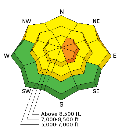
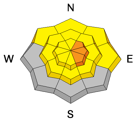
bottom line Heightened avalanche conditions exist in the backcountry and there's a MODERATE or level 2 danger this morning on drifted upper and mid elevation slopes. You could trigger large cornice falls or wind slab avalanches 1 to 2 feet deep in steep terrain with recent wind deposits. Rapid daytime warming could create dangerous conditions in some areas, and a CONSIDERABLE or level 3 danger of heat related or wet avalanches may develop on steep slopes in areas with significant fresh accumulations. Evaluate the snow and terrain carefully
|
 |
special announcement Sale on all remaining discount lift tickets donated to the Utah Avalanche Center from Beaver Mountain, Wolf Mountain, Sundance, and Brian Head: The few remaining tickets are being blown out with all proceeds used to pay for avalanche advisories and education. Go here to get your tickets. |
 |
current conditions Should be nice spring powder conditions today in the backcountry, but midday warming may cause dangerous avalanche conditions to develop in some areas. You'll find around bit less than a foot of new snow from yesterday above about 7000' in the Bear River Range, with more reported in the Front Canyons. The Tony Grove Snotel at 8400' reports 10 inches of new snow from yesterday, containing 1.2 inches of water. It's 24 degrees, and there's 109 inches of total snow, with 131% of average water content for the date. There's 8 new inches up at Beaver Mountain. It's 17 degrees at the 9700' CSI Logan Peak weather station, and I'm reading average wind speeds in the lower teens from the west currently.
|
 |
recent activity Apparently, two people triggered and were caught and carried by separate soft slab avalanches in the Central Wasatch Backcountry yesterday. No avalanches were reported recently in the Logan Zone. Visit our Backcountry Observations Page for details on the season's activity.
|
| type | aspect/elevation | characteristics |
|---|

|
|
LIKELIHOOD
 LIKELY
UNLIKELY
SIZE
 LARGE
SMALL
TREND
 INCREASING DANGER
SAME
DECREASING DANGER
|
description
|
| type | aspect/elevation | characteristics |
|---|

|
|
LIKELIHOOD
LIKELY
UNLIKELY
SIZE
LARGE
SMALL
TREND
 INCREASING DANGER
SAME
DECREASING DANGER
|
|
description
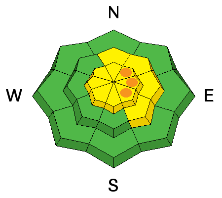
Wet or heat related avalanches will become likely on slopes with significant fresh accumulations as the day warms up, and greenhousing or rapid warming could cause dangerous avalanche conditions to develop. Some natural loose and soft slab avalanches entraining significant piles of moist fresh snow are possible and triggered avalanches likely as slopes are initially heated and the new snow becomes damp and cohesive.
|
 |
weather Should stay mostly cloudy today, with a high temperature at 8500' around 35 degrees, and moderate west winds will hopefully keep things cool. Expect a low of 28 degrees tonight with mostly cloudy skies and increasing southwest wind. It'll be warmer and breezy tomorrow, and the next round of snowy weather is expected tomorrow night through Sunday, with 6 to 14 inches of total accumulation possible Check out our one-stop weather page........HERE |
| general announcements Utah Avalanche Center mobile app - Get your advisory on your iPhone along with great navigation and rescue tools. Remember your information can save lives. If you see anything we should know about, please participate in the creation of our own community avalanche advisory by submitting snow and avalanche conditions. You can also call us at 801-524-5304 or 800-662-4140, email by clicking HERE, or include #utavy in your tweet or Instagram. Follow us at UAClogan on Twitter I'll issue these advisories on Monday, Wednesday, Friday, and Saturday mornings through March, and will then switch to issuing weekend and intermittent advisories through April. This advisory is produced by the U.S.D.A. Forest Service, which is solely responsible for its content. It describes only general avalanche conditions and local variations always exist. |


_1.jpg)

