
| During the month of April, Mark Miller will donate $75 to the charity of your choice (5 to chose from, including the Utah Avalanche Center!) Mark Miller Subaru has raised over $300k in the previous 6 Do Good Feel Good events. More Info here |  |
| During the month of April, Mark Miller will donate $75 to the charity of your choice (5 to chose from, including the Utah Avalanche Center!) Mark Miller Subaru has raised over $300k in the previous 6 Do Good Feel Good events. More Info here | |
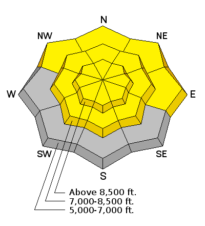
| Advisory: Logan Area Mountains | Issued by Toby Weed for Wednesday - March 26, 2014 - 7:07am |
|---|

|
bottom line Heightened avalanche conditions exist in the backcountry and there's a MODERATE or level 2 danger. You could trigger shallow fresh and/or developing wind slabs or cornice falls in drifted upper elevation terrain, and wet avalanches are possible on some melt-softened slopes after very warm temperatures yesterday and a poor overnight refreeze. Evaluate the snow and terrain carefully
|
 |
special announcement Sale on all remaining discount lift tickets donated to the Utah Avalanche Center from Beaver Mountain, Wolf Mountain, Sundance, and Brian Head: The few remaining tickets are being blown out with all proceeds used to pay for avalanche advisories and education. Go here to get your tickets.
Snow coverage and conditions are stellar at Beaver Mountain this spring. 3-12-2014 |
 |
current conditions Temperatures remained mild last night, and snow surface refreezes were poor. Surface crusts are likely to be rather superficial, capping warm, moist, and in some cases soft dusty old snow. At 1:00 this morning, the Tony Grove Snotel at 8400' reported 43 degrees, and there was 98 inches of total snow, with 130% of average water content for the date. Temperatures appear to be dropping and it's 28 degrees at the 9700' CSI Logan Peak weather station. I'm reading average wind speeds in the lower teens from the west currently, diminishing after averaging over 30 mph for a few hours overnight.
|
 |
recent activity No avalanches were reported recently in the Logan Zone. Visit our Backcountry Observations Page for details on the season's activity.
|
| type | aspect/elevation | characteristics |
|---|

|
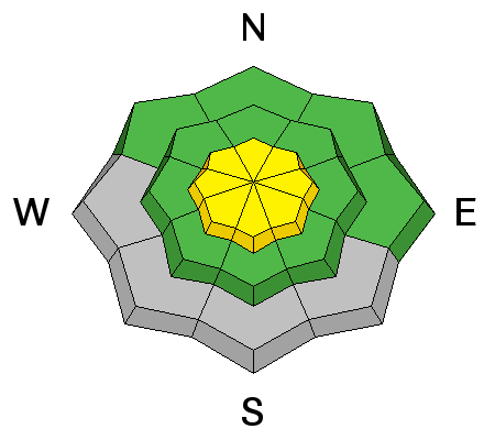
|
LIKELIHOOD
 LIKELY
UNLIKELY
SIZE
 LARGE
SMALL
TREND
 INCREASING DANGER
SAME
DECREASING DANGER
|
description
|
| type | aspect/elevation | characteristics |
|---|

|
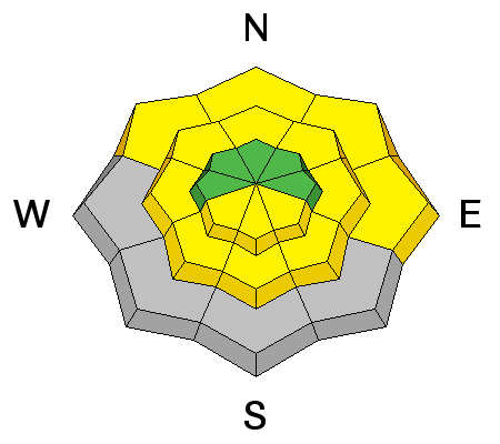
|
LIKELIHOOD
 LIKELY
UNLIKELY
SIZE
LARGE
SMALL
TREND
INCREASING DANGER
SAME
DECREASING DANGER
|
|
description
Wet avalanches will remain possible on slopes with warmth softened snow, with only gradual cooling today after fairly warm overnight temperatures. Avoid slopes with wet snow that you sink into or post-holing situations.
|
 |
weather Snow is likely today, with fairly strong west wind, 8500' high temperatures around 40 degrees, and 3 to 7 inches of accumulation forecast, some thunder is also possible. We'll see a bit of a break tonight, with southwest winds, temperatures dropping to around 22 degrees and 1 to 3 inches possible. It'll be much colder tomorrow, with a high of 31 degrees, strong and gusty southwest winds, some thunder possible, and 8 to 12 inches of accumulation forecast. We should see another short-lived break on Friday before more storms in a springtime train swing through the region; a pattern continuing well into next week. Check out our one-stop weather page........HERE |
| general announcements Utah Avalanche Center mobile app - Get your advisory on your iPhone along with great navigation and rescue tools. Remember your information can save lives. If you see anything we should know about, please participate in the creation of our own community avalanche advisory by submitting snow and avalanche conditions. You can also call us at 801-524-5304 or 800-662-4140, email by clicking HERE, or include #utavy in your tweet or Instagram. Follow us at UAClogan on Twitter I'll issue these advisories on Monday, Wednesday, Friday, and Saturday mornings through March, and will then switch to issuing weekend and intermittent advisories through April. This advisory is produced by the U.S.D.A. Forest Service, which is solely responsible for its content. It describes only general avalanche conditions and local variations always exist. |


_1.jpg)

