
| During the month of April, Mark Miller will donate $75 to the charity of your choice (5 to chose from, including the Utah Avalanche Center!) Mark Miller Subaru has raised over $300k in the previous 6 Do Good Feel Good events. More Info here |  |
| During the month of April, Mark Miller will donate $75 to the charity of your choice (5 to chose from, including the Utah Avalanche Center!) Mark Miller Subaru has raised over $300k in the previous 6 Do Good Feel Good events. More Info here | |
| Advisory: Logan Area Mountains | Issued by Toby Weed for Monday - March 24, 2014 - 7:10am |
|---|

|
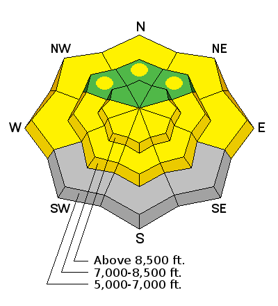
bottom line The snow stability is generally good and the danger is LOW or level 1 on most slopes in the backcountry this morning. Daytime warming may cause heightened conditions and a level 2 or MODERATE danger of wet avalanches on some sheltered, sunny slopes this afternoon and tomorrow. Use normal caution. Avoid large cornices and drifted slopes at upper elevations and steep sunny slopes with saturated snow in the heat of the day.
|
 |
special announcement Sale on all remaining discount lift tickets donated to the Utah Avalanche Center from Beaver Mountain, Wolf Mountain, Sundance, and Brian Head: The few remaining tickets are being blown out with all proceeds used to pay for avalanche advisories and education. Go here to get your tickets.
Snow coverage and conditions are stellar at Beaver Mountain this spring. 3-12-2014 |
 |
current conditions The Tony Grove Snotel at 8400' reports 28 degrees, and there's 104 inches of total snow, with 131% of average water content for the date. It's 18 degrees at the 9700' CSI Logan Peak weather station, and I'm reading average wind speeds in the lower twenties from the west-northwest. March winds deposited brown dust across the zone, which is concentrated by melting on the snow surface and will increase the melt rate. You'll find stable spring snow conditions and easy traveling in the backcountry today, but seasonal warmth and lots of sun will probably soften up some slopes today, making them slow and slushy.
|
 |
recent activity No avalanches were reported recently in the Logan Zone. Visit our Backcountry Observations Page for details on the season's activity.
|
| type | aspect/elevation | characteristics |
|---|

|

|
LIKELIHOOD
 LIKELY
UNLIKELY
SIZE
 LARGE
SMALL
TREND
 INCREASING DANGER
SAME
DECREASING DANGER
|
|
description
Even when the danger is mostly LOW we need asses the danger on individual slopes and continue to use safe travel protocols. Low danger doesn't mean No danger. Avalanches are unlikely in most areas, which also means they are possible in some.
|
| type | aspect/elevation | characteristics |
|---|

|
|
LIKELIHOOD
 LIKELY
UNLIKELY
SIZE
LARGE
SMALL
TREND
INCREASING DANGER
SAME
DECREASING DANGER
|
|
description
Wet avalanches will become possible in sunny sheltered terrain as the day warms up, and anytime you encounter slushy or soft wet snow conditions you should reconsider your route. As usual, avoid and stay out from under steep slopes with saturated surface snow, and pay close attention to trees and other terrain traps below you. If you start post-holing, or if you sink knee-deep or deeper into wet snow, you could trigger wet avalanches and it's time to leave.
|
 |
weather Expect sunny conditions in the mountains, with moderate west winds and 8500' high temperatures around 40 degrees. It'll be partly cloudy tonight, with somewhat mild temperatures, around 29 degrees and moderate west-southwest wind. It'll be windy and very warm tomorrow, with intensifying southwest wind and mountain temperatures pushing 50 degrees. Snow is likely late Tuesday night into Wednesday, with some thunder also possible and 3 to 7 inches of accumulation forecast. Looks like snow will continue through Thursday with an additional 6 to 10 inches possible by late Thursday... Check out our one-stop weather page........HERE |
| general announcements Utah Avalanche Center mobile app - Get your advisory on your iPhone along with great navigation and rescue tools. Remember your information can save lives. If you see anything we should know about, please participate in the creation of our own community avalanche advisory by submitting snow and avalanche conditions. You can also call us at 801-524-5304 or 800-662-4140, email by clicking HERE, or include #utavy in your tweet or Instagram. Follow us at UAClogan on Twitter I'll issue these advisories on Monday, Wednesday, Friday, and Saturday mornings through March, and will then switch to issuing weekend and intermittent advisories through April. This advisory is produced by the U.S.D.A. Forest Service, which is solely responsible for its content. It describes only general avalanche conditions and local variations always exist. |


_1.jpg)


