
| During the month of April, Mark Miller will donate $75 to the charity of your choice (5 to chose from, including the Utah Avalanche Center!) Mark Miller Subaru has raised over $300k in the previous 6 Do Good Feel Good events. More Info here |  |
| During the month of April, Mark Miller will donate $75 to the charity of your choice (5 to chose from, including the Utah Avalanche Center!) Mark Miller Subaru has raised over $300k in the previous 6 Do Good Feel Good events. More Info here | |
| Advisory: Logan Area Mountains | Issued by Toby Weed for Wednesday - March 19, 2014 - 6:41am |
|---|

|
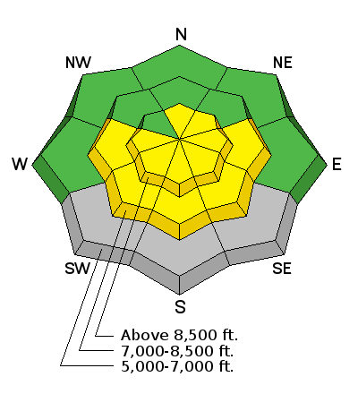
bottom line Heightened avalanche conditions exist and there is a MODERATE or level 2 danger this morning on drifted slopes at upper elevations, with triggered wind slab avalanches and cornice-falls possible. Rapid warming of yesterday's cold snow will create heightened wet avalanche conditions in sunny terrain, with some natural activity possible, and triggered entraining loose wet sluffs becoming likely with midday heating. Evaluate the snow and terrain carefully. Avoid drifted slopes and large cornices at upper elevations and steep sunny slopes with saturated fresh snow in the heat of the day.
|
 |
special announcement Sale on all remaining discount lift tickets donated to the Utah Avalanche Center from Beaver Mountain, Wolf Mountain, Sundance, and Brian Head: The few remaining tickets are being blown out with all proceeds used to pay for avalanche advisories and education. Go here to get your tickets.
Snow coverage and conditions are stellar at Beaver Mountain this spring. 3-12-2014 |
 |
current conditions The Tony Grove Snotel at 8400' reports 9 inches of new snow containing an inch of water in the last 48 hours. I'm reading 14 degrees at the station, and there's 115 inches of total snow, with 135% of average water content for the date. It's 11 degrees at the 9700' CSI Logan Peak weather station, and the wind sensor is stopped by rime-ice. I'm reading zero degrees this morning at the UDOT Hwy 89 Logan Summit weather station and very light northeast winds.
A sure sign of Spring. Tundra Swans flocking in the Bear River Delta below Ben Lomond and Willard Peak. 3-15-2014
|
 |
recent activity It's been a couple weeks since any avalanches stepping into old snow occurred in the Logan Zone. Shallow wind slabs and cornice falls are fairly frequent during and just after the spring storms, and easily predicted loose wet avalanches have been common with solar heating and seasonal warmth affecting fresh snow. Visit our Backcountry Observations Page for more details.
|
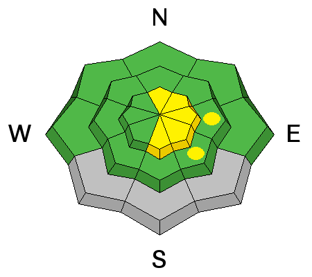
| type | aspect/elevation | characteristics |
|---|

|
|
LIKELIHOOD
 LIKELY
UNLIKELY
SIZE
 LARGE
SMALL
TREND
 INCREASING DANGER
SAME
DECREASING DANGER
|
|
description
Wind slab avalanches involving drifted fresh snow up to about a foot deep are possible in wind-exposed upper elevation terrain. These should be mostly of the manageable variety for experienced travelers, but some might be a bit bigger than you expect and a few might be stiff enough to allow you to get out on the slab before it fails.
|
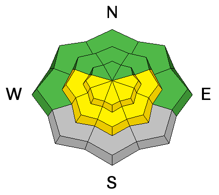
| type | aspect/elevation | characteristics |
|---|

|
|
LIKELIHOOD
LIKELY
UNLIKELY
SIZE
LARGE
SMALL
TREND
 INCREASING DANGER
SAME
DECREASING DANGER
|
|
description
Loose wet avalanches entraining the fresh snow will become likely in sunny terrain as the day warms up. Expect rapid warming of the cold fresh snow, with the danger increasing around the compass with the sun from east to south to west... Avoid and stay out from under steep slopes with saturated fresh surface snow, and pay close attention to trees and other terrain traps below you. Roller balls, pin-wheels, and sluffs indicate unstable wet surface snow, and entraining loose wet avalanches are likely in these conditions.
|
 |
weather Expect sunny conditions in the mountains, with moderate west-southwest winds and 8500' high temperatures around 32 degrees. It'll be party cloudy tonight, with temperatures around 22 degrees and west winds averaging in the mid teens along the ridges. Looks a bit warmer on Thursday, with mostly sunny skies, breezy west winds and high temperatures around 36 degrees. A dry cold front will move through the region on Thursday evening, and a weak Pacific storm system will cross through the region on Saturday. Check out our one-stop weather page........HERE |
| general announcements Can you change Utah in a day? Utah's non-profit community is a big part of what makes living in Utah great. Join your community in a state-wide day of non-profit appreciation and support with Love Utah Give Utah on Thursday, March 20. Your donation to the Utah Avalanche Center between now andMarch 20 through this link, large or small, helps pay for avalanche advisories and education and makes the Utah Avalanche Center eligible for challenge grants and special awards provided by local businesses. In Salt Lake City? Stop by Squatters downtown on Th 3/20 between 4 and 6 for some free snacks, an opportunity to chat with some of the UAC folks, and make an online donation. Show Us You Know the Snow: US & Canadian avy groups have a challenge to sidecountry riders: Use your camera to tell a short video story about how your crew gets ready to safely ride beyond the resort boundary. Videos will be posted & promoted by GoPro & other partners. The contest will run till Mar 21. The winner will be determined by a combination of most views & an expert panel. Prizes include: 2 days at Monashee Powder Snowcats, 2 4-day Gold Passes to any US resort, a Backcountry Access Float 22 airbag, gear from Backcountry.com, editing help and support from Sherpas Cinema, & more. Winners will be announced in late March. . Details at knowthesnow.com Please share this with your friends Utah Avalanche Center mobile app - Get your advisory on your iPhone along with great navigation and rescue tools. Remember your information can save lives. If you see anything we should know about, please participate in the creation of our own community avalanche advisory by submitting snow and avalanche conditions. You can also call us at 801-524-5304 or 800-662-4140, email by clicking HERE, or include #utavy in your tweet or Instagram. Follow us at UAClogan on Twitter I'll issue these advisories on Monday, Wednesday, Friday, and Saturday mornings through the month of March. This advisory is produced by the U.S.D.A. Forest Service, which is solely responsible for its content. It describes only general avalanche conditions and local variations always exist. |


_1.jpg)


