| During the month of April, Mark Miller will donate $75 to the charity of your choice (5 to chose from, including the Utah Avalanche Center!) Mark Miller Subaru has raised over $300k in the previous 6 Do Good Feel Good events. More Info here |  |
| During the month of April, Mark Miller will donate $75 to the charity of your choice (5 to chose from, including the Utah Avalanche Center!) Mark Miller Subaru has raised over $300k in the previous 6 Do Good Feel Good events. More Info here | |
| Advisory: Logan Area Mountains | Issued by Toby Weed for Friday - March 14, 2014 - 7:18am |
|---|

|
bottom line Most slopes are stable, and there is a LOW or level 1 danger in the backcountry. Avalanches are generally unlikely this morning but still possible in extreme or "Big Mountain" terrain. Solar warming will cause an increasing danger of loose wet avalanches as the day heats up, and shallow entraining wet sluffs are possible in some steep sunny areas. Use normal caution, avoid steep slopes with saturated surface snow, and continue to practice safe backcountry travel protocols.
|
 |
current conditions The Tony Grove Snotel at 8400' reports 114 inches of total snow, and 135% of average water content for the date. It's 23 degrees at the 9700' CSI Logan Peak weather station, which recorded steady west-northwest winds overnight with average wind speeds in the upper teens. We found and observers report smiley faces on our companions, safe stable snow, and very nice shallow powder or smooth dust-on-crust riding conditions across the Bear River Range during USU's spring break this week.
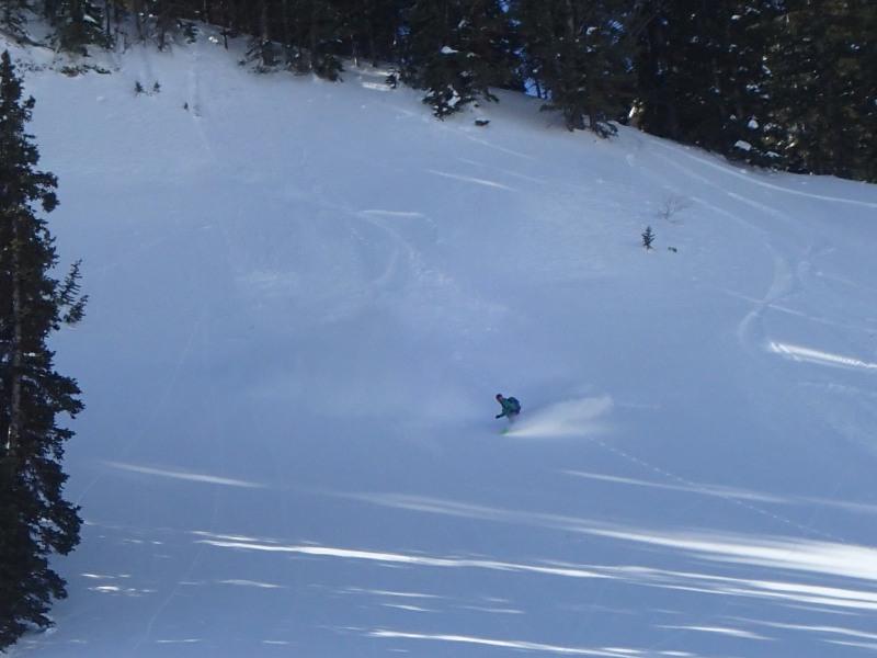
Liam sampling some nice smooth dust-on-crust above Bear Lake. 3-12-2014
|
 |
recent activity Observers reported intentionally triggering a few shallow soft slabs in the Tony Grove Area on Wednesday, and evidence of recent shallow natural loose wet activity and roller balling is visible on many slopes above Cache Valley, but it's been a couple weeks since any significant avalanche reports in the Logan Zone.
Intentionally triggering shallow and very manageable soft slabs in the Tony Grove Area on Wednesday 3-12-2014. (Flygare)
|
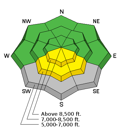
| type | aspect/elevation | characteristics |
|---|

|

|
LIKELIHOOD
 LIKELY
UNLIKELY
SIZE
 LARGE
SMALL
TREND
 INCREASING DANGER
SAME
DECREASING DANGER
|
|
description
The danger is LOW in most terrain this morning, but we still need to employ good situational awareness and continue to practice safe travel protocols in the backcountry. Wind slab avalanches involving drifted fresh snow up to about a foot deep are possible in wind exposed upper elevation terrain.
|
| type | aspect/elevation | characteristics |
|---|

|
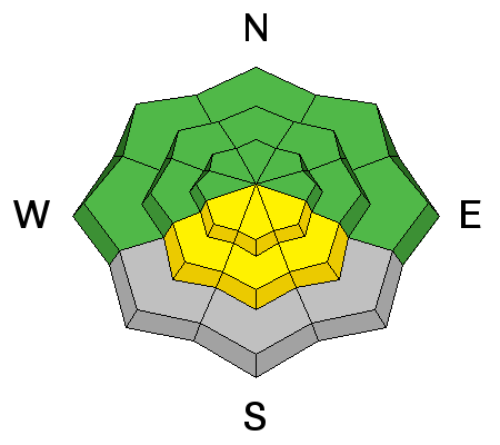
|
LIKELIHOOD
 LIKELY
UNLIKELY
SIZE
 LARGE
SMALL
TREND
INCREASING DANGER
SAME
DECREASING DANGER
|
|
description
Wet avalanches involving and entraining moist surface snow are possible in the heat of midday on steep sunny slopes.
|
 |
weather Expect lots of sun and mild temperatures in the mountains today. 8500' high temperatures are expected to be around 38 degrees, with moderate westerly winds on the ridges. Snow showers are likely tonight, with 2 to 4 inches of accumulation possible and fairly strong and gusty northwest winds intensifying in the evening. Temperatures should drop to around 21 degrees overnight. It'll be nice and sunny again tomorrow, with a bit of a northwest breeze and high temperatures right around freezing. Check out our one-stop weather page........HERE |
| general announcements Campsaver and The Utah Avalanche Center in Logan are teaming up to give away a avalanche rescue kit - beacon, shovel and probe! Show Us You Know the Snow: US & Canadian avy groups have a challenge to sidecountry riders: Use your camera to tell a short video story about how your crew gets ready to safely ride beyond the resort boundary. Videos will be posted & promoted by GoPro & other partners. The contest will run till Mar 21. The winner will be determined by a combination of most views & an expert panel. Prizes include: 2 days at Monashee Powder Snowcats, 2 4-day Gold Passes to any US resort, a Backcountry Access Float 22 airbag, gear from Backcountry.com, editing help and support from Sherpas Cinema, & more. Winners will be announced in late March. . Details at knowthesnow.com Please share this with your friends Discount lift tickets are available at Backcountry.com - Thanks to Ski Utah and the Utah Resorts, including Beaver Mountain. All proceeds go towards paying for Utah Avalanche Center avalanche and mountain weather advisories. Utah Avalanche Center mobile app - Get your advisory on your iPhone along with great navigation and rescue tools. Remember your information can save lives. If you see anything we should know about, please participate in the creation of our own community avalanche advisory by submitting snow and avalanche conditions. You can also call us at 801-524-5304 or 800-662-4140, email by clicking HERE, or include #utavy in your tweet or Instagram. Follow us at UAClogan on Twitter I'll issue these advisories on Monday, Wednesday, Friday, and Saturday mornings. This advisory is produced by the U.S.D.A. Forest Service, which is solely responsible for its content. It describes only general avalanche conditions and local variations always exist. |


_1.jpg)