| During the month of April, Mark Miller will donate $75 to the charity of your choice (5 to chose from, including the Utah Avalanche Center!) Mark Miller Subaru has raised over $300k in the previous 6 Do Good Feel Good events. More Info here |  |
| During the month of April, Mark Miller will donate $75 to the charity of your choice (5 to chose from, including the Utah Avalanche Center!) Mark Miller Subaru has raised over $300k in the previous 6 Do Good Feel Good events. More Info here | |
| Advisory: Logan Area Mountains | Issued by Toby Weed for Wednesday - March 12, 2014 - 7:14am |
|---|

|
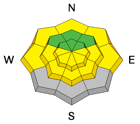
bottom line Heightened avalanche conditions exist, and there is a MODERATE or level 2 danger on drifted slopes at upper elevations in the backcountry. You could trigger shallow wind slab avalanches consisting of fresh snow up to around a foot deep in steep wind exposed terrain. Solar warming will cause an increasing danger of loose wet avalanches entraining the fresh snow in steep sun-warmed terrain as the day heats up, and wet sluffs will become likely in some areas. Evaluate the snow and terrain carefully, and continue to use safe backcountry travel protocols.
|
 |
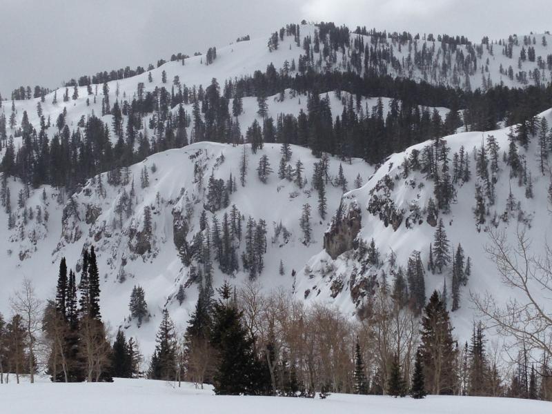
current conditions It's a cool 21 degrees this morning, and the Tony Grove Snotel at 8400' reports several inches of new snow containing an even inch of water in the last 48 hrs. There's 118 inches of total snow, and 137% of average water content for the date. It's 13 degrees at the 9700' CSI Logan Peak weather station, which recorded steady light north winds overnight with single digit average wind speeds. We found mostly stable snow and very nice shallow powder riding conditions yesterday in the Tony Grove area.
The Tony Grove area is quite filled-in with about 137% of average SWE (snow water equivalent) at the Tony Grove Snotel. Many rocky landmarks are deeply buried, and slopes are wide and smooth. 3-11-2014
|
 |
recent activity
The scene of Friday's (3-7-2014) fatal avalanche in the Western Unitas that killed a Honeyville man. 3-8-2014 (Meisenheimer)
|
| type | aspect/elevation | characteristics |
|---|

|
|
LIKELIHOOD
 LIKELY
UNLIKELY
SIZE
 LARGE
SMALL
TREND
 INCREASING DANGER
SAME
DECREASING DANGER
|
|
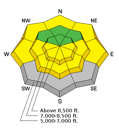
description
The danger is LOW in most terrain this morning, but we still need to employ good situational awareness and continue to practice safe travel protocols in the backcountry. Wind slab avalanches involving drifted fresh snow up to about a foot deep are possible in wind exposed upper elevation terrain.
|
| type | aspect/elevation | characteristics |
|---|

|
|
LIKELIHOOD
 LIKELY
UNLIKELY
SIZE
LARGE
SMALL
TREND
 INCREASING DANGER
SAME
DECREASING DANGER
|
|
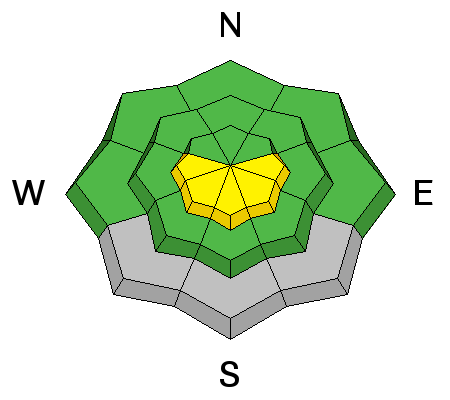
description
Wet avalanches involving and entraining moist fresh snow are likely in the heat of midday on steep sunny slopes and at lower elevations. Avoid and stay out from under steep slopes with saturated surface snow, and be especially careful above trees, benches, or other terrain traps that you could be dragged into. The snow can turn from nice light powder to moist, cohesive, glopp very quickly this time of year with a higher springtime sun angle. You know it's time to leave if you see roller balls, or natural surface sluffs on similar slopes, or if you start sinking deeply into wet snow. Wet sluff triggering video from 2-28-2014.... HERE
|
 |
weather Looks like nice weather in store for the remainder of the week. It'll be sunny today with 8500' high temperatures around 34 degrees and light northeast winds this morning becoming more variable tonight. It'll be mostly clear tonight, with low temperatures around 22 degrees. It'll be sunny tomorrow, with high temperatures in the mid thirties and light to moderate west wind. And it'll be mostly sunny on Friday as well, with a chance of some snow showers Friday night.... Check out our one-stop weather page........HERE |
| general announcements Campsaver and The Utah Avalanche Center in Logan are teaming up to give away a avalanche rescue kit - beacon, shovel and probe! Show Us You Know the Snow: US & Canadian avy groups have a challenge to sidecountry riders: Use your camera to tell a short video story about how your crew gets ready to safely ride beyond the resort boundary. Videos will be posted & promoted by GoPro & other partners. The contest will run till Mar 21. The winner will be determined by a combination of most views & an expert panel. Prizes include: 2 days at Monashee Powder Snowcats, 2 4-day Gold Passes to any US resort, a Backcountry Access Float 22 airbag, gear from Backcountry.com, editing help and support from Sherpas Cinema, & more. Winners will be announced in late March. . Details at knowthesnow.com Please share this with your friends Discount lift tickets are available at Backcountry.com - Thanks to Ski Utah and the Utah Resorts, including Beaver Mountain. All proceeds go towards paying for Utah Avalanche Center avalanche and mountain weather advisories. Utah Avalanche Center mobile app - Get your advisory on your iPhone along with great navigation and rescue tools. Remember your information can save lives. If you see anything we should know about, please participate in the creation of our own community avalanche advisory by submitting snow and avalanche conditions. You can also call us at 801-524-5304 or 800-662-4140, email by clicking HERE, or include #utavy in your tweet or Instagram. Follow us at UAClogan on Twitter I'll issue these advisories on Monday, Wednesday, Friday, and Saturday mornings. This advisory is produced by the U.S.D.A. Forest Service, which is solely responsible for its content. It describes only general avalanche conditions and local variations always exist. |


_1.jpg)