
| During the month of April, Mark Miller will donate $75 to the charity of your choice (5 to chose from, including the Utah Avalanche Center!) Mark Miller Subaru has raised over $300k in the previous 6 Do Good Feel Good events. More Info here |  |
| During the month of April, Mark Miller will donate $75 to the charity of your choice (5 to chose from, including the Utah Avalanche Center!) Mark Miller Subaru has raised over $300k in the previous 6 Do Good Feel Good events. More Info here | |
| Advisory: Logan Area Mountains | Issued by Toby Weed for Monday - March 10, 2014 - 7:11am |
|---|


|
bottom line There is a LOW or level 1 danger on most slopes, and with the exceptions of obvious huge cornices and some drifted upper elevation slopes, avalanches are generally unlikely in the backcountry this morning. Warming midday temperatures after a poor overnight freeze will cause heightened wet avalanche conditions and a MODERATE or level 2 danger in some areas. Evaluate the snow and terrain carefully, and continue to use safe backcountry travel protocols.
|
 |
current conditions A poor overnight refreeze in the Logan Zone means only superficial surface crusts, which will likely be breakable in places and will soften up pretty quickly with warm midday temperatures. It's 38 degrees this morning, and the Tony Grove Snotel at 8400' reports 115 inches of total snow, and 136% of average water content for the date. Mt Ogden reports 30+ mph average southwest winds with gusts in the mid-forties and 34 degrees.
|
 |
recent activity
|
| type | aspect/elevation | characteristics |
|---|

|
|
LIKELIHOOD
 LIKELY
UNLIKELY
SIZE
 LARGE
SMALL
TREND
 INCREASING DANGER
SAME
DECREASING DANGER
|
|
description
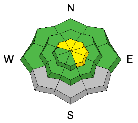
The danger is mostly LOW this morning, but we still need to employ good situational awareness and continue to practice safe travel protocols in the backcountry.
|
| type | aspect/elevation | characteristics |
|---|

|
|
LIKELIHOOD
LIKELY
UNLIKELY
SIZE
LARGE
SMALL
TREND
 INCREASING DANGER
SAME
DECREASING DANGER
|
|
description
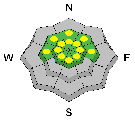
The widespread weak faceted snow from the first half of the season snow appears dormant, and is so deeply buried and bridged now at upper elevations in the Central Bear River Range that It would be difficult for us to trigger a deep slab avalanche. Dangerous deep slab avalanches failing on faceted weak layers near the bottom of the snowpack are unlikely but still possible in outlying shallow, rocky, steep, terrain, especially where the snow (the slab) is softened by warmth.
|
| type | aspect/elevation | characteristics |
|---|

|

|
LIKELIHOOD
 LIKELY
UNLIKELY
SIZE
 LARGE
SMALL
TREND
INCREASING DANGER
SAME
DECREASING DANGER
|
|
description
Wet avalanches are possible in the heat of midday on steep warmth or rain-softened slopes. Avoid and stay out from under steep slopes with saturated soft snow, and be especially careful above trees, benches, or other terrain traps that you could be dragged into. You know it's time to leave if you start sinking deeply into wet snow.
|
 |
weather It'll be warm and windy today, with snow showers likely this afternoon and 8500' high temperatures around 42 degrees. Expect strong and increasing southwest winds and a couple inches of accumulation is possible. It'll snow tonight and some thunder is possible. Expect low temperatures of around 20 degrees and 5 to 9 inches of accumulation. Strong north-northwest winds will gradually diminish after midnight. Snow and blustery conditions are likely on Tuesday, with temperatures in the mid twenties and northeast winds. Looks like warmth and lots of sun on Wednesday.
This morning's Satellite image showing the next moist and mild storm, which will bring snow to the mountains tonight. Check out our one-stop weather page........HERE |
| general announcements Campsaver and The Utah Avalanche Center in Logan are teaming up to give away a avalanche rescue kit - beacon, shovel and probe! Show Us You Know the Snow: US & Canadian avy groups have a challenge to sidecountry riders: Use your camera to tell a short video story about how your crew gets ready to safely ride beyond the resort boundary. Videos will be posted & promoted by GoPro & other partners. The contest will run till Mar 21. The winner will be determined by a combination of most views & an expert panel. Prizes include: 2 days at Monashee Powder Snowcats, 2 4-day Gold Passes to any US resort, a Backcountry Access Float 22 airbag, gear from Backcountry.com, editing help and support from Sherpas Cinema, & more. Winners will be announced in late March. . Details at knowthesnow.com Please share this with your friends Discount lift tickets are available at Backcountry.com - Thanks to Ski Utah and the Utah Resorts, including Beaver Mountain. All proceeds go towards paying for Utah Avalanche Center avalanche and mountain weather advisories. Utah Avalanche Center mobile app - Get your advisory on your iPhone along with great navigation and rescue tools. Remember your information can save lives. If you see anything we should know about, please participate in the creation of our own community avalanche advisory by submitting snow and avalanche conditions. You can also call us at 801-524-5304 or 800-662-4140, email by clicking HERE, or include #utavy in your tweet or Instagram. Follow us at UAClogan on Twitter I'll issue these advisories on Monday, Wednesday, Friday, and Saturday mornings. This advisory is produced by the U.S.D.A. Forest Service, which is solely responsible for its content. It describes only general avalanche conditions and local variations always exist. |


_1.jpg)

