| During the month of April, Mark Miller will donate $75 to the charity of your choice (5 to chose from, including the Utah Avalanche Center!) Mark Miller Subaru has raised over $300k in the previous 6 Do Good Feel Good events. More Info here |  |
| During the month of April, Mark Miller will donate $75 to the charity of your choice (5 to chose from, including the Utah Avalanche Center!) Mark Miller Subaru has raised over $300k in the previous 6 Do Good Feel Good events. More Info here | |
| Advisory: Logan Area Mountains | Issued by Toby Weed for Saturday - March 1, 2014 - 7:17am |
|---|

|
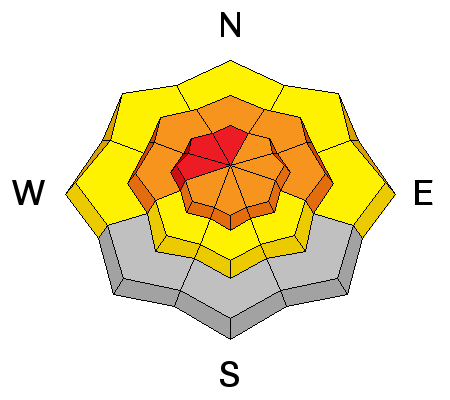
bottom line There is a HIGH or Level 4 danger on drifted slopes in the backcountry. Natural and triggered wind slab avalanches and large cornice falls are likely up upper and mid elevations, and storm slabs and entraining wet sluffs are likely at mid and lower elevations. Dangerous deep slab avalanches are possible where the slab is shallow and might be remotely triggered from a distance or below. Avoid travel in avalanche terrain. Stay off of and out from under steep slopes and obvious or historic avalanche paths.
|
 |
avalanche warning THIS AVALANCHE WARNING IS FOR THE MOUNTAINS OF NORTHERN AND CENTRAL UTAH. HEAVY SNOW AND HIGH WIND WILL CREATE A HIGH AVALANCHE DANGER. BACKCOUNTRY TRAVELERS SHOULD STAY ON SLOPES LESS THAN 30 DEGREES AND AVOID AVALANCHE RUN OUT AREAS. |
 |
current conditions The 8400' Tony Grove Snotel, reports 31 degrees this morning, about 6 inches of heavy new snow containing an inch of water from overnight, and 108 inches of total snow, containing 122% of average water content for the date. The 9700' CSI Logan Peak weather station reports 25 degrees, and average wind speeds of around 30 mph from the south southwest this morning, with gusts of over 60 mph.
This morning's 700hPa EarthWindMap
|
 |
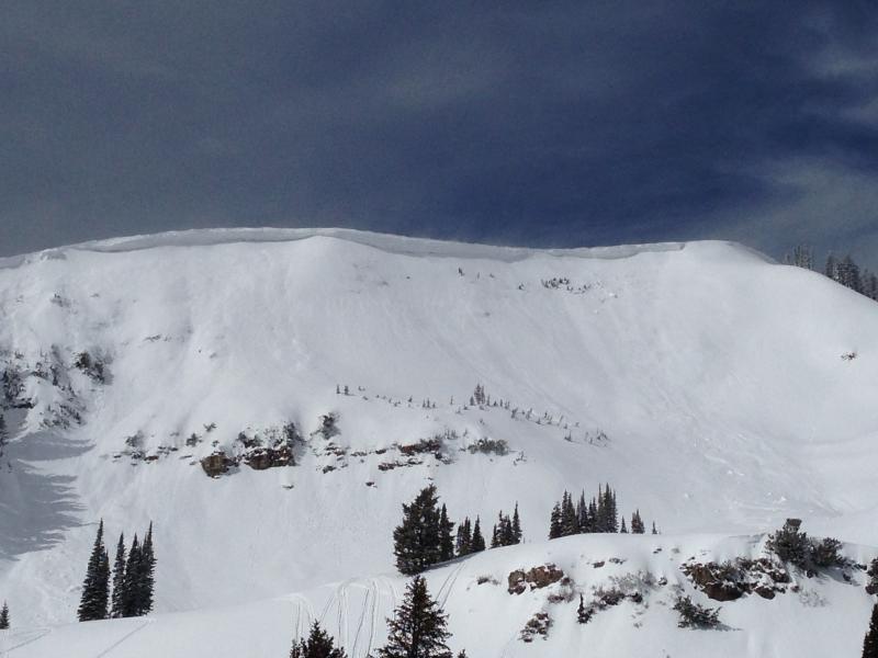
recent activity A recent natural wind slab avalanche involving cornice fall was reported yesterday from upper Cottonwood Canyon in the Mount Naomi Wilderness. A few natural and human triggered wind slab avalanches and cornice falls were also observed and reported from upper elevation terrain, having occurred earlier in the week. It was very easy to trigger entraining wet sluffs yesterday on test slopes at mid-elevations in Providence Canyon, and these could get pretty big on longer slopes.
Providence Peak from the east, showing a large, built-out cornice and evidence of some fairly recent avalanche activity below it. 2-28-2014
|
| type | aspect/elevation | characteristics |
|---|

|
|
LIKELIHOOD
 LIKELY
UNLIKELY
SIZE
 LARGE
SMALL
TREND
 INCREASING DANGER
SAME
DECREASING DANGER
|
|
description
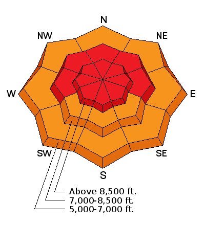
Natural and triggered wind slab avalanches up to 2-feet-deep and large cornice-falls are likely in drifted terrain today. Wind slab and storm snow avalanches in the Wasatch Range yesterday involving the new snow ran far and packed a punch. Avoid and stay out from under drifted slopes and recently formed and forming cornices along ridge-lines, which are likely to break further back than you expect.
|
| type | aspect/elevation | characteristics |
|---|

|
|
LIKELIHOOD
LIKELY
UNLIKELY
SIZE
LARGE
SMALL
TREND
INCREASING DANGER
SAME
DECREASING DANGER
|
|
description
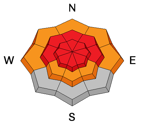
Many avalanche problems associated with heavy new snow and rain up into mid elevations are creating dangerous avalanche conditions in steep terrain today.
Easily triggered wet sluffs on mid-elevation test slopes in Providence Canyon. VIDEO
|
| type | aspect/elevation | characteristics |
|---|

|
|
LIKELIHOOD
 LIKELY
UNLIKELY
SIZE
 LARGE
SMALL
TREND
 INCREASING DANGER
SAME
DECREASING DANGER
|
|
description
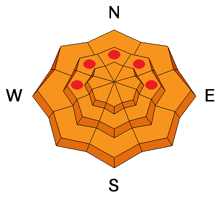
Warm temperatures, a new load from heavy accumulations and drifting could reactivate dormant deeply buried persistent weak layers. Dangerous deep slab avalanches failing on faceted weak layers at the bottom of the snowpack are possible today, especially on drifted upper and mid elevation slopes. Be especially cautious in shallow, rocky terrain, and you might trigger a deep slab from a shallower area on the slab. Deep slab avalanches might be triggered remotely, from a distance or below.
|
 |
weather Drifting snow will be a big issue as strong southwest winds continue and more snow falls, with 7 to 11 inches of additional accumulation forecast today and another 5 to 9 possible tonight. The winds should gradually diminish tonight and be more reasonable on Sunday. Check out our one-stop weather page........HERE |
| general announcements Campsaver and The Utah Avalanche Center in Logan are teaming up to give away a avalanche rescue kit - beacon, shovel and probe! Show Us You Know the Snow: US & Canadian avy groups have a challenge to sidecountry riders: Use your camera to tell a short video story about how your crew gets ready to safely ride beyond the resort boundary. Videos will be posted & promoted by GoPro & other partners. The contest will run till Mar 21. The winner will be determined by a combination of most views & an expert panel. Prizes include: 2 days at Monashee Powder Snowcats, 2 4-day Gold Passes to any US resort, a Backcountry Access Float 22 airbag, gear from Backcountry.com, editing help and support from Sherpas Cinema, & more. Winners will be announced in late March. . Details at knowthesnow.com Please share this with your friends A video look at a HUGE natural avalanche in the Wellsville Range, from 2-19-2014...........HERE Check out "Beaver Backside is the Backcountry," an Avalanche observation video from 2-16-2014 .....HERE A child's perspective on last week's natural wet avalanche above Zanavoo in Logan Canyon filmed on 2-17-2014 .......HERE Discount lift tickets are available at Backcountry.com - Thanks to Ski Utah and the Utah Resorts, including Beaver Mountain. All proceeds go towards paying for Utah Avalanche Center avalanche and mountain weather advisories. Utah Avalanche Center mobile app - Get your advisory on your iPhone along with great navigation and rescue tools. Remember your information can save lives. If you see anything we should know about, please participate in the creation of our own community avalanche advisory by submitting snow and avalanche conditions. You can also call us at 801-524-5304 or 800-662-4140, email by clicking HERE, or include #utavy in your tweet or Instagram. Follow us at UAClogan on Twitter I'll issue these advisories on Monday, Wednesday, Friday, and Saturday mornings. This advisory is produced by the U.S.D.A. Forest Service, which is solely responsible for its content. It describes only general avalanche conditions and local variations always exist. |


_1.jpg)