| During the month of April, Mark Miller will donate $75 to the charity of your choice (5 to chose from, including the Utah Avalanche Center!) Mark Miller Subaru has raised over $300k in the previous 6 Do Good Feel Good events. More Info here |  |
| During the month of April, Mark Miller will donate $75 to the charity of your choice (5 to chose from, including the Utah Avalanche Center!) Mark Miller Subaru has raised over $300k in the previous 6 Do Good Feel Good events. More Info here | |
| Advisory: Logan Area Mountains | Issued by Toby Weed for Friday - February 28, 2014 - 7:22am |
|---|

|
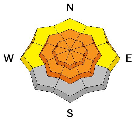
bottom line Dangerous avalanche conditions exist and there's a CONSIDERABLE or Level 3 danger in the backcountry. Triggered storm snow, wind slab, cornice-falls, and wet avalanches are all likely, and some natural avalanches are possible in steep terrain today. Dangerous deep slab avalanches are possible and might be remotely or directly triggered from a shallower area. Intensifying southwest winds will create a rising avalanche danger, likely rising to HIGH in many areas overnight. Careful snowpack evaluation, cautious route-finding, and conservative decision making will be essential for safe travel in the backcountry today.
|
 |
avalanche watch THIS AVALANCHE WATCH IS FOR THE MOUNTAINS OF NORTHERN AND CENTRAL UTAH. HEAVY SNOW AND STRONG WIND WILL CREATE A HIGH AVALANCHE DANGER FRIDAY NIGHT AND SATURDAY. BACKCOUNTRY TRAVELERS SHOULD AVOID SLOPES STEEPER THAN 30 DEGREES AND AVOID AVALANCHE RUN OUT AREAS THIS WEEKEND. THIS WATCH DOES NOT INCLUDE SKI AREAS OR HIGHWAYS WHERE AVALANCHE CONTROL IS NORMALLY DONE. |
 |
special announcement We will hold an Avalanche Awareness class for riders on Saturday March 1 at 9 am Providence Canyon snowmobile parking lot. Register on line HERE or call 757-2794 for more info. |
 |
current conditions Rain up to around 7500' and very wet snowfall up higher created saturated and sloppy snow conditions everywhere yesterday. Thankfully, overnight temperatures dropped down to 27 degrees at the 8400' Tony Grove Snotel, and more snow fell overnight. The station reports 8 inches of heavy new snow containing 1.4" of water from the last 24 hours and 103 inches of total snow, containing 121% of average water content for the date. The 9700' CSI Logan Peak weather station reports 21 degrees, and diminishing average wind speeds of around 10 mph from the west southwest this morning after sustaining 20 mph averages overnight. Expect increasing southwest winds this afternoon, becoming strong overnight.
Many windward (SW and west) facing slopes at upper elevations were scoured to the bone by sustained strong winds late in the mid February storm cycle.
|
 |
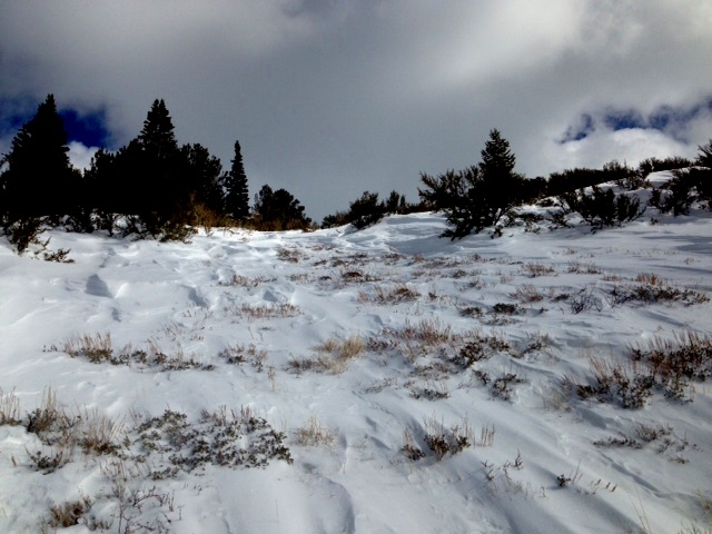
recent activity Observers report triggering wet sluffs in steep terrain, cracking in the wet new snow, and extensive roller balls yesterday, with the moist snow problems found at all elevations and including north facing terrain. Also of note, a party reports triggering a whumpf or audible collapse in shallow wind-scoured upper elevation terrain in the Swan Peak area on Wednesday. A few natural and human triggered wind slab avalanches and cornice falls were observed and reported earlier in the week.
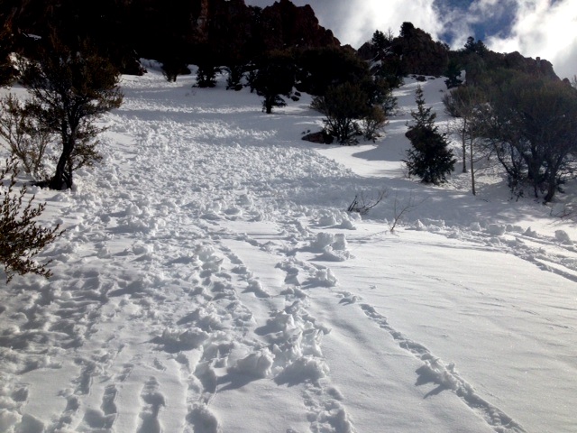
Roller balls indicating saturated surface snow, and a natural wind slab avalanche off Mt.Magog's south ridge from 2-24-2014
|
| type | aspect/elevation | characteristics |
|---|

|
|
LIKELIHOOD
 LIKELY
UNLIKELY
SIZE
 LARGE
SMALL
TREND
 INCREASING DANGER
SAME
DECREASING DANGER
|
|
description
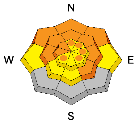
Many avalanche problems associated with the heavy new snow and rain from yesterday and overnight are creating dangerous avalanche conditions in steep terrain today. Triggered loose sluffs entraining significant piles of heavy new snow and soft storm slabs up to around a foot deep are likely on many upper and mid elevation slopes. Stiffer wind slab avalanches up to 2 feet deep and sizable cornice-falls are possible in drifted upper elevation terrain, and will become more likely as southwest winds increase during the day drifting the fresh snow in to avalanche starting zones. Avoid recently formed and forming cornices along ridge-lines, which are likely to break further back than you expect, and stiffer drifted snow or potential wind slabs on the lee sides of major ridge lines and in and around terrain features like rock outcroppings, sub-ridges and gullies.
|
| type | aspect/elevation | characteristics |
|---|

|
|
LIKELIHOOD
LIKELY
UNLIKELY
SIZE
 LARGE
SMALL
TREND
INCREASING DANGER
SAME
DECREASING DANGER
|
|
description
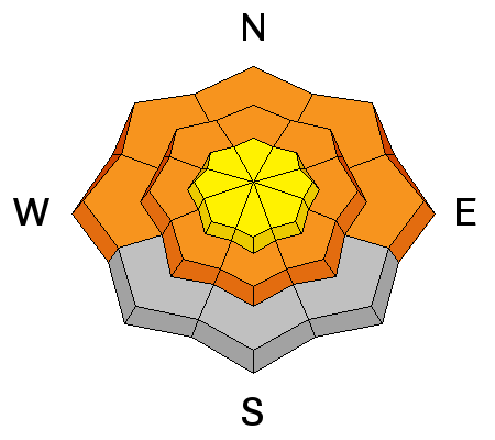
Warm temperatures, a new load from yesterday and overnight accumulations, and drifting from increasing southwest winds could reactivate dormant deeply buried persistent weak layers. Dangerous deep slab avalanches failing on preexisting faceted weak layers at the bottom of the snowpack are possible today, especially on drifted upper and mid elevation slopes. Be especially cautious in shallow, rocky terrain, and you might trigger a deep slab from a shallower area on the slab. Deep slab avalanches might be triggered remotely, from a distance or below.
|
| type | aspect/elevation | characteristics |
|---|

|
|
LIKELIHOOD
LIKELY
UNLIKELY
SIZE
LARGE
SMALL
TREND
 INCREASING DANGER
SAME
DECREASING DANGER
|
|
description
Wet avalanches, entraining significant piles of saturated fresh snow are likely in steep terrain. Avoid and stay out from under steep slopes with saturated snow and be especially careful above trees, benches or other terrain traps that you could be dragged into. |
 |
weather We might see some snow showers today in the mountains, but little in the way of accumulations. Expect mostly cloudy skies and 8500' temperatures around 33 degrees and increasing southwest wind. Temperatures will drop to around 27 degrees overnight, it'll snow with 2 to 4 inches forecast and southwest winds will intensify and become quite strong. Drifting snow will be a big issue tomorrow as strong southwest winds continue and more snow falls, with 3 to 7 inches of additional accumulation forecast. The winds should diminish by Sunday and cloudy unsettled weather will continue well into the coming work week. Check out our one-stop weather page........HERE |
| general announcements Campsaver and The Utah Avalanche Center in Logan are teaming up to give away a avalanche rescue kit - beacon, shovel and probe! Show Us You Know the Snow: US & Canadian avy groups have a challenge to sidecountry riders: Use your camera to tell a short video story about how your crew gets ready to safely ride beyond the resort boundary. Videos will be posted & promoted by GoPro & other partners. The contest will run till Mar 21. The winner will be determined by a combination of most views & an expert panel. Prizes include: 2 days at Monashee Powder Snowcats, 2 4-day Gold Passes to any US resort, a Backcountry Access Float 22 airbag, gear from Backcountry.com, editing help and support from Sherpas Cinema, & more. Winners will be announced in late March. . Details at knowthesnow.com Please share this with your friends A video look at a HUGE natural avalanche in the Wellsville Range, from 2-19-2014...........HERE Check out "Beaver Backside is the Backcountry," an Avalanche observation video from 2-16-2014 .....HERE A child's perspective on last week's natural wet avalanche above Zanavoo in Logan Canyon filmed on 2-17-2014 .......HERE Discount lift tickets are available at Backcountry.com - Thanks to Ski Utah and the Utah Resorts, including Beaver Mountain. All proceeds go towards paying for Utah Avalanche Center avalanche and mountain weather advisories. Utah Avalanche Center mobile app - Get your advisory on your iPhone along with great navigation and rescue tools. Remember your information can save lives. If you see anything we should know about, please participate in the creation of our own community avalanche advisory by submitting snow and avalanche conditions. You can also call us at 801-524-5304 or 800-662-4140, email by clicking HERE, or include #utavy in your tweet or Instagram. Follow us at UAClogan on Twitter I'll issue these advisories on Monday, Wednesday, Friday, and Saturday mornings. This advisory is produced by the U.S.D.A. Forest Service, which is solely responsible for its content. It describes only general avalanche conditions and local variations always exist. |


_1.jpg)