| During the month of April, Mark Miller will donate $75 to the charity of your choice (5 to chose from, including the Utah Avalanche Center!) Mark Miller Subaru has raised over $300k in the previous 6 Do Good Feel Good events. More Info here |  |
| During the month of April, Mark Miller will donate $75 to the charity of your choice (5 to chose from, including the Utah Avalanche Center!) Mark Miller Subaru has raised over $300k in the previous 6 Do Good Feel Good events. More Info here | |
| Advisory: Logan Area Mountains | Issued by Toby Weed for Sunday - February 23, 2014 - 5:56am |
|---|

|
bottom line There's a CONSIDERABLE or Level 3 avalanche danger on steep drifted slopes at upper and mid elevations. Triggered wind slab avalanches, cornice falls, and loose sluffs are likely, and you still might trigger very dangerous and destructive deep slab avalanches in steep terrain from shallow areas. In many areas the danger is lower, Level 2 or MODERATE, with heightened avalanche conditions in drifted terrain. You can still find safer, mostly stable snow conditions at lower elevations and in sheltered lower angled terrain. Careful snowpack evaluation, cautious route-finding, and conservative decision making will be essential for safe travel in the backcountry today.
|
 |
current conditions The Logan Summit weather cam is showing snowfall again this morning, and the 8400' Tony Grove Snotel reports well over a foot of new snow containing 1.2 inches of water yesterday, bringing the last two day's accumulation up to about 18 inches. It's 25 degrees and there's 108 inches of total snow, containing 122% of average water content for the date. The 9700' CSI Logan Peak weather station reports 17 degrees and average wind speeds in the mid teens from the west southwest this morning. Beaver Mountain picked up 8 inches yesterday and overnight. Colder temperatures solidified the saturated weak snow at lower elevations, and you stay on top of a solidly refrozen crust in the fresh snow from the past couple days. Powder riding conditions up high are described as epic, but most people are avoiding steep terrain due to widespread poor snow structure and the lingering chance of triggering an un-survivable avalanche. Bruce Tremper just published a Storm Analysis Blog that explains aspects our recent active natural avalanche cycle. HERE And he explains this weekend's generalized snow situation well in this video
|
 |
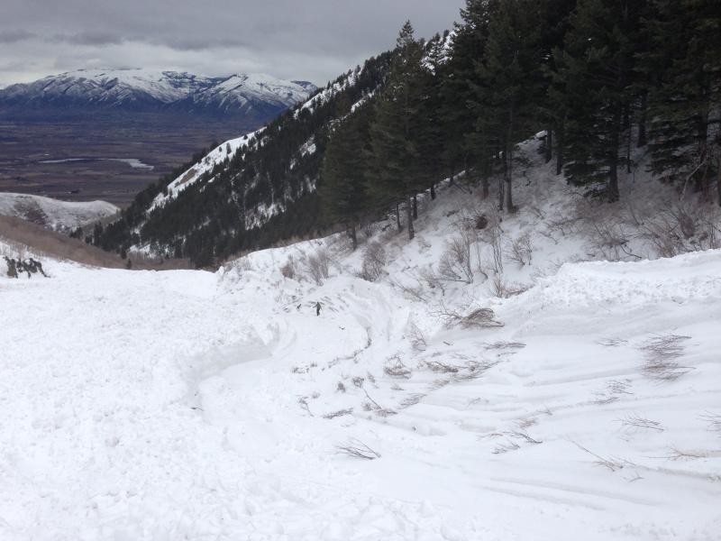
recent activity It's been a week since our last reported avalanche activity in the Logan Zone. Evidence of the extensive and widespread natural cycle, which cumulated last weekend is still quite apparent across the zone, especially at lower elevations and in places that didn't get so much snow in the past couple days, and reports of large and destructive natural avalanches continue to filter in. Thanks to everyone for your observations this week, and please keep em coming.
Looking at a very large natural avalanche in Pine Canyon in the Wellsville Mountain Wilderness on 2-19-2014 ***Video look at a HUGE natural avalanche in the Wellsville Range, from 2-19-2014...........HERE Last week, in addition to numerous large natural avalanches in the backcountry, there were a few close calls with dangerous unintentionally triggered avalanches and another incredibly lucky survival story in the Providence Canyon Area, in which a rider was completely buried, rescued by his partners unconscious and unresponsive, but recovered and was able to ride out on his own....SEE REPORT Check out "Beaver Backside is the Backcountry," an Avalanche observation video from 2-16-2014 .....HERE A child's perspective on last week's natural wet avalanche above Zanavoo in Logan Canyon filmed on 2-17-2014 .......HERE
|
| type | aspect/elevation | characteristics |
|---|

|
|
LIKELIHOOD
 LIKELY
UNLIKELY
SIZE
 LARGE
SMALL
TREND
 INCREASING DANGER
SAME
DECREASING DANGER
|
|
description
The instability from last week's rapid loading appears to settling be out with time and it is increasingly unlikely the you would trigger one, but dangerous triggered deep slab avalanches failing on preexisting faceted weak layers at the bottom of the snowpack remain possible today, especially on drifted upper and mid elevation slopes that didn't naturally avalanche in the recent prolonged cycle. Drifted slopes with shallow overall snow cover are the most suspect, since shallow areas tend to harbor the weakest snow. Although ever more unlikely, you still might trigger dangerous avalanches remotely, from a distance or even from the flats below steep slopes in some cases.
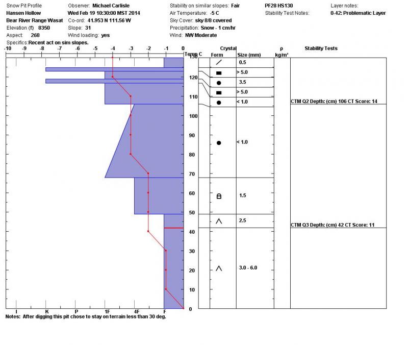
A Snow profile from the Franklin Basin Area showing very poor snow structure. At least the weak facets in the Basal layers are deeply buried in many areas now, so deep slab avalanches would be fairly hard for us to trigger. Shallow areas, where the slab is less than around 3' deep are the more likely trigger points. (Carlisle)
|
| type | aspect/elevation | characteristics |
|---|

|

|
LIKELIHOOD
LIKELY
UNLIKELY
SIZE
 LARGE
SMALL
TREND
 INCREASING DANGER
SAME
DECREASING DANGER
|
|
description
Triggered wind slab avalanches and cornice falls are likely on steep slopes, and a smaller avalanche overrunning a slope with poor snow structure might cause a step-down into weak old snow and result in a much larger and more dangerous deep slab avalanche. Avoid freshly formed cornices along exposed ridge-lines, which are likely to break further back than you expect and stiffer drifted fresh snow on the lee sides of major ridge lines and in and around terrain features like rock outcroppings and gullies.
|
| type | aspect/elevation | characteristics |
|---|

|
|
LIKELIHOOD
LIKELY
UNLIKELY
SIZE
 LARGE
SMALL
TREND
 INCREASING DANGER
SAME
DECREASING DANGER
|
|
description
The Tony Grove Snotel reported 13 inches of new snow in a 6 hr period yesterday morning. After yesterday's rapid accumulation at upper elevations, some loose sluffs naturally ran in steep terrain. Triggered sluffs and soft storm slabs could be an issue in steep terrain again today, but these should be mostly manageable. Watch for trees and other terrain traps below you if you do venture onto steeper slopes. |
 |
weather It's snowing again this morning in the Bear River Range and more snow is possible this morning, but we might see a bit of sunshine this afternoon Expect a high temperature of 33 degrees at 8500' and continuing moderately strong west winds. It'll be partly cloudy tonight, with low temperatures in the mid twenties. Expect unsettled weather with a couple grazing storms to our north through midweek. Looks like a more significant and productive zonal pattern will set up, with accumulating snow a good bet on around Thursday. Check out our one-stop weather page........HERE |
| general announcements Discount lift tickets are available at Backcountry.com - Thanks to Ski Utah and the Utah Resorts, including Beaver Mountain. All proceeds go towards paying for Utah Avalanche Center avalanche and mountain weather advisories. Utah Avalanche Center mobile app - Get your advisory on your iPhone along with great navigation and rescue tools. Remember your information can save lives. If you see anything we should know about, please participate in the creation of our own community avalanche advisory by submitting snow and avalanche conditions. You can also call us at 801-524-5304 or 800-662-4140, email by clicking HERE, or include #utavy in your tweet or Instagram. Follow us at UAClogan on Twitter I'll issue these advisories on Monday, Wednesday, Friday, and Saturday mornings. This advisory is produced by the U.S.D.A. Forest Service, which is solely responsible for its content. It describes only general avalanche conditions and local variations always exist. |


_1.jpg)