| During the month of April, Mark Miller will donate $75 to the charity of your choice (5 to chose from, including the Utah Avalanche Center!) Mark Miller Subaru has raised over $300k in the previous 6 Do Good Feel Good events. More Info here |  |
| During the month of April, Mark Miller will donate $75 to the charity of your choice (5 to chose from, including the Utah Avalanche Center!) Mark Miller Subaru has raised over $300k in the previous 6 Do Good Feel Good events. More Info here | |
| Advisory: Logan Area Mountains | Issued by Toby Weed for Wednesday - February 19, 2014 - 7:27am |
|---|

|
bottom line There's a CONSIDERABLE or Level 3 avalanche danger on steep drifted slopes at upper and mid elevations in the in the Logan Area backcountry. The danger of wind slab avalanches will increase and become more widespread with snowfall and drifting today, and you could trigger very dangerous and destructive deep slab avalanches in steep terrain. Deep slab avalanches might be triggered remotely, from a distance, or the flats below steep slopes. Careful snowpack evaluation, cautious route-finding, and conservative decision making will be essential for safe travel in the backcountry today.
|
 |
special announcement Come join the Utah Avalanche Center in Logan for a FREE avalanche awareness program Thursday February 20th at 6pm at the Providence South Stake Center, 360 East 450 North, Millville. Bring a friend! FOR MORE INFORMATION CALL 757-2794 |
 |
current conditions Cooling is helping to solidify the saturated weak snow at lower elevations, and instabilities are gradually settling out at upper and mid elevations. But, dangerous deep slab conditions still exist on steep slopes that didn't naturally avalanche in the recent prolonged cycle, and we should continue to use extra caution in the backcountry. The Tony Grove Snotel reports 31 degrees at 3:00 this morning and 95 inches of total snow, containing 121% of average water content for the date. The 9700' CSI Logan Peak weather station reports 22 degrees and 30 mph average wind speeds from the southwest, with gusts over 60 mph this morning. Bruce Tremper just published a Storm Analysis Blog that explains aspects our recent active natural avalanche cycle. HERE
|
 |
recent activity After a prolonged and very active avalanche cycle in the Logan Zone it's been 3 days since our last reported avalanche activity. Last week, in addition to numerous large natural avalanches in the backcountry, there were a few close calls with dangerous unintentionally triggered avalanches and another incredibly lucky survival story in the Providence Canyon Area, in which a rider was completely buried, rescued by his partners unconscious and unresponsive, but recovered and was able to ride out on his own....SEE REPORT
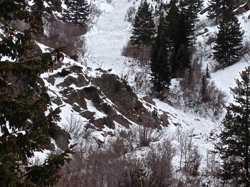
We're still finding evidence of the weekend's fairly extensive natural avalanche cycle. This one is in Cherry Creek Canyon in the Mount Naomi Wilderness. Several trees were mowed down and there is an impressive pile of snow snaking down this long gully. 2-18-2014 Check out "Beaver Backside is the Backcountry," an Avalanche observation video from 2-16-2014 .....HERE A child's perspective on last week's natural wet avalanche above Zanavoo in Logan Canyon filmed on 2-17-2014 .......HERE A HUGE natural avalanche in the Wellsville Range, from 2-19-2014...........HERE
|
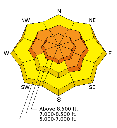
| type | aspect/elevation | characteristics |
|---|

|

|
LIKELIHOOD
 LIKELY
UNLIKELY
SIZE
 LARGE
SMALL
TREND
 INCREASING DANGER
SAME
DECREASING DANGER
|
|
description
Dangerous triggered deep slab avalanches failing on preexisting faceted weak layers at the bottom of the snowpack remain possible today, especially on drifted upper and mid elevation slopes. You still might trigger dangerous avalanches remotely, from a distance or even from the flats below steep slopes. Drifted slopes with shallow overall snow cover are the most suspect, since shallow areas tend to harbor the weakest snow. I'm planning on giving slopes that didn't naturally avalanche in the recent cycle a bit more time to settle out.
|
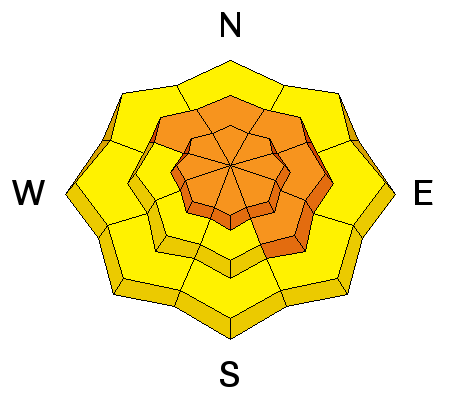
| type | aspect/elevation | characteristics |
|---|

|
|
LIKELIHOOD
 LIKELY
UNLIKELY
SIZE
 LARGE
SMALL
TREND
 INCREASING DANGER
SAME
DECREASING DANGER
|
|
description
Fresh drifts will quickly build today in exposed upper and mid-elevation terrain. Triggered wind slab avalanches are likely on steep slopes, and a smaller avalanche overrunning a slope with poor snow structure could cause a step-down into weak old snow and result in a much larger and more dangerous deep slab avalanche. Avoid stiffer drifted snow on the lee sides of major ridge lines and in and around terrain features like rock outcroppings and gullies.
|
 |
weather Another storm and a good chance of 3 to 7 inches of snow is on our doorstep. Expect snowfall, heavy at times in the mountains today, with mountain temperatures gradually dropping into the mid teens and fairly strong westerly winds. More snowfall is expected tonight and tomorrow, with another shot of more significant snow likely Thursday night, lasting into Friday. Check out our one-stop weather page........HERE |
| general announcements Discount lift tickets are available at Backcountry.com - Thanks to Ski Utah and the Utah Resorts, including Beaver Mountain. All proceeds go towards paying for Utah Avalanche Center avalanche and mountain weather advisories. Utah Avalanche Center mobile app - Get your advisory on your iPhone along with great navigation and rescue tools. Remember your information can save lives. If you see anything we should know about, please participate in the creation of our own community avalanche advisory by submitting snow and avalanche conditions. You can also call us at 801-524-5304 or 800-662-4140, email by clicking HERE, or include #utavy in your tweet or Instagram. Follow us at UAClogan on Twitter I'll issue these advisories on Monday, Wednesday, Friday, and Saturday mornings. This advisory is produced by the U.S.D.A. Forest Service, which is solely responsible for its content. It describes only general avalanche conditions and local variations always exist. |


_1.jpg)