
| During the month of April, Mark Miller will donate $75 to the charity of your choice (5 to chose from, including the Utah Avalanche Center!) Mark Miller Subaru has raised over $300k in the previous 6 Do Good Feel Good events. More Info here |  |
| During the month of April, Mark Miller will donate $75 to the charity of your choice (5 to chose from, including the Utah Avalanche Center!) Mark Miller Subaru has raised over $300k in the previous 6 Do Good Feel Good events. More Info here | |
| Advisory: Logan Area Mountains | Issued by Toby Weed for Monday - February 17, 2014 - 7:00am |
|---|

|
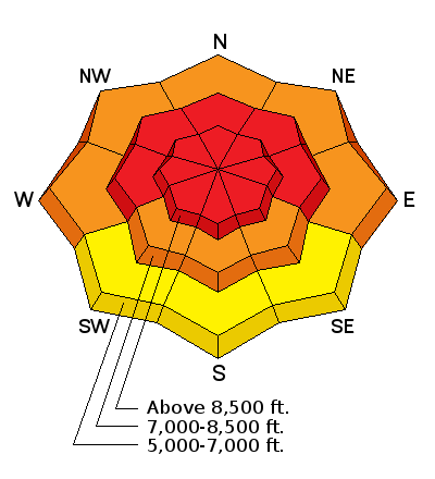
bottom line There's a HIGH or Level 4 avalanche danger on steep drifted slopes at upper and mid elevations in the in the Logan Area backcountry. Natural and triggered wind slab avalanches are likely, and you could trigger very dangerous and destructive deep slab avalanches in steep terrain. Deep slab avalanches could be triggered remotely, from a distance, or the flats below steep slopes. Continue to stay off of and out from under steep slopes and obvious or historic avalanche paths.
|
 |
avalanche warning THE FOLLOWING MESSAGE IS TRANSMITTED AT THE REQUEST OF THE FOREST SERVICE UTAH AVALANCHE CENTER. THIS AVALANCHE WARNING IS FOR THE MOUNTAINS OF NORTHERN AND CENTRAL UTAH. A HIGH AVALANCHE DANGER CONTINUES WITH LARGE, NATURAL AND HUMAN TRIGGERED AVALANCHES POSSIBLE. BACKCOUNTRY TRAVELERS SHOULD AVOID SLOPES STEEPER THAN 30 DEGREES AND AVALANCHE RUNNOUT AREAS. THIS WARNING DOES NOT INCLUDE SKI AREAS OR HIGHWAYS WHERE AVALANCHE CONTROL IS NORMALLY DONE. |
 |
current conditions Accidents are likely in the backcountry on a sunny holiday with dangerous avalanche conditions. The Tony Grove Snotel reports 3 inches of graupel and rimed new snow from yesterday, and 99 inches of total snow, reading 125% of average water content for the date. The station picked up almost 6 inches of water in a couple feet of heavy snow since February 11. It's currently 23 degrees, with a low overnight temperature of 16. The 9700' CSI Logan Peak weather station reports 17 degrees and average wind speeds of around 30 mph from the southwest this morning.
Strong southwest winds in the afternoon whipping up yesterday's fresh snow in upper Logan Canyon. (2-16-2014)
|
 |
recent activity
This is the backcountry! A large wet slab avalanche low on the Beaver Backside occurred during the day on Saturday, 2-15-2014.
|
| type | aspect/elevation | characteristics |
|---|

|
|
LIKELIHOOD
 LIKELY
UNLIKELY
SIZE
 LARGE
SMALL
TREND
 INCREASING DANGER
SAME
DECREASING DANGER
|
|
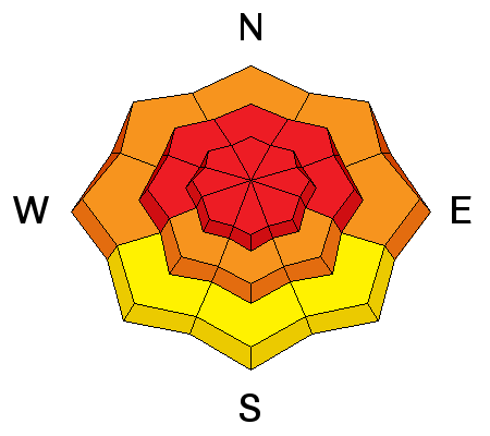
description
Dangerous triggered deep slab avalanches failing on preexisting faceted weak layers at the bottom of the snowpack remain likely today, especially on drifted upper elevation slopes. You could trigger dangerous avalanches remotely, from a distance or even from the flats below steep slopes. Many large and long running natural avalanches occurred in the Logan Zone in the past few days, and more are possible again today, so stay away from and out from under avalanche paths.
Large and long running natural avalanche in Pine Canyon in the Wellsville Mountain Wilderness from 2-13-2014
|
| type | aspect/elevation | characteristics |
|---|

|
|
LIKELIHOOD
LIKELY
UNLIKELY
SIZE
 LARGE
SMALL
TREND
 INCREASING DANGER
SAME
DECREASING DANGER
|
|
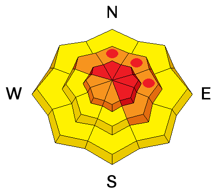
description
Fresh drifts formed yesterday and overnight in exposed upper and mid-elevation terrain. Triggered wind slab avalanches are likely on steep slopes again today, and a smaller avalanche overrunning a slope with poor snow structure or saturated snow could cause a step-down into weak old snow and result in a much larger and more dangerous avalanche. Avoid stiffer drifted snow on the lee sides of major ridge lines and in and around terrain features like rock outcroppings and gullies.
|
| type | aspect/elevation | characteristics |
|---|

|
|
LIKELIHOOD
 LIKELY
UNLIKELY
SIZE
LARGE
SMALL
TREND
INCREASING DANGER
SAME
DECREASING DANGER
|
|
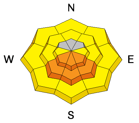
description
Rain saturated lower elevation snow, and warm temperatures kept it soft and unstable, and we've seen some large and scary wet slabs in the area this weekend. But, cooler temperatures overnight and a good refreeze should help the situation significantly today. Solar warming could cause the saturated snow on sunny sheltered slopes at lower and mid elevations to soften up though, potentially creating dangerous wet avalanche conditions in some areas. |
 |
weather It'll be mostly sunny today, with mountain temperatures in the mid thirties and sustained moderate southwest winds. Breezy conditions will persist overnight and be a bit stronger tomorrow morning, with overnight temperatures in the mid twenties and around freezing tomorrow. Another storm and a good chance of 3 to 7 inches of snow will arrive early Wednesday. More snowfall is expected Thursday night into Friday. Check out our one-stop weather page........HERE |
| general announcements Discount lift tickets are available at Backcountry.com - Thanks to Ski Utah and the Utah Resorts, including Beaver Mountain. All proceeds go towards paying for Utah Avalanche Center avalanche and mountain weather advisories. Utah Avalanche Center mobile app - Get your advisory on your iPhone along with great navigation and rescue tools. Remember your information can save lives. If you see anything we should know about, please participate in the creation of our own community avalanche advisory by submitting snow and avalanche conditions. You can also call us at 801-524-5304 or 800-662-4140, email by clicking HERE, or include #utavy in your tweet or Instagram. Follow us at UAClogan on Twitter I'll issue these advisories on Monday, Wednesday, Friday, and Saturday mornings. This advisory is produced by the U.S.D.A. Forest Service, which is solely responsible for its content. It describes only general avalanche conditions and local variations always exist. |


_1.jpg)


