| During the month of April, Mark Miller will donate $75 to the charity of your choice (5 to chose from, including the Utah Avalanche Center!) Mark Miller Subaru has raised over $300k in the previous 6 Do Good Feel Good events. More Info here |  |
| During the month of April, Mark Miller will donate $75 to the charity of your choice (5 to chose from, including the Utah Avalanche Center!) Mark Miller Subaru has raised over $300k in the previous 6 Do Good Feel Good events. More Info here | |
| Advisory: Logan Area Mountains | Issued by Toby Weed for Friday - February 14, 2014 - 7:03am |
|---|

|
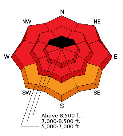
bottom line There is a HIGH or Level 4 avalanche danger in the backcountry. Dangerous avalanches are likely on slopes at all elevations and on slopes facing all directions due to continuing mild temperatures, rain, and widespread preexisting weak snow. Several large and long-running natural avalanches occurred yesterday and more are likely today at upper elevations. Dangerous persistent slab avalanches could be triggered remotely, from a distance, or the flats below steep slopes. Avalanche conditions could become even more dangerous due to rising temperatures as we head into the weekend. Avoid all travel in avalanche terrain. Stay off of and out from under steep slopes and obvious or historic avalanche paths.
|
 |
avalanche warning THE FOLLOWING MESSAGE IS TRANSMITTED AT THE REQUEST OF THE FOREST SERVICE UTAH AVALANCHE CENTER. THIS AVALANCHE WARNING IS FOR THE LOGAN AREA MOUNTAINS...THE MOUNTAINS OF SOUTHEASTERN IDAHO...THE WESTERN UINTAS...AND THE MANTI-SKYLINE SOUTH TO INTERSTATE 70. DANGEROUS AVALANCHE CONDITIONS EXIST ON ALL ASPECTS AND ELEVATIONS. AVOID BEING ON OR BENEATH STEEP TERRAIN...AS AVALANCHES MAY BE TRIGGERED FROM BELOW. THIS WARNING DOES NOT INCLUDE SKI AREAS OR HIGHWAYS WHERE AVALANCHE CONTROL IS NORMALLY DONE. |
 |
current conditions Very dangerous avalanche conditions exist in the backcountry. Several large and long running natural avalanches occurred yesterday and more are possible today. The Tony Grove Snotel reports a few more inches of heavy snow and 1.5 inches of water in the last 24 hours and 3.2 in the last 48. It's currently 24 degrees, and there's 96 inches of total snow, amazingly now up to 122% of average water content for the date. West winds moderated significantly overnight after cranking out 30 mph average wind speeds with a 55 mph gust yesterday afternoon and evening at the Hwy 89 Logan summit weather station. Avalanche conditions are unusually bad across the region due to widespread and very weak faceted snow plaguing the basal layers of the snowpack at all elevations and on slopes facing every direction. Backcountry travelers face more dangerous and widespread avalanche conditions than we've seen in years, and we need to be extremely conservative right now. Rain up into the mid elevations and gradual but significant warming will keep the overall danger HIGH in the backcountry as we head into the weekend.
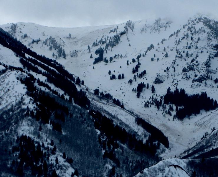
A large natural avalanche visible from across Cache Valley in Pine Canyon in the Wellsville Mountain Wilderness.(2-13-2014)
|
 |
recent activity
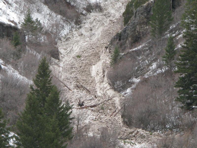
Large natural avalanche above Zanavoo occurred during the day Thursday. Thankfully, it stopped well above the Logan River. (2-13-2014)
|
| type | aspect/elevation | characteristics |
|---|

|

|
LIKELIHOOD
 LIKELY
UNLIKELY
SIZE
 LARGE
SMALL
TREND
 INCREASING DANGER
SAME
DECREASING DANGER
|
|
description
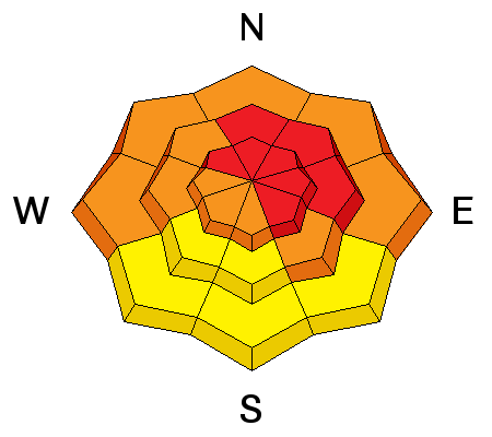
Rain and warming temperatures in the next couple days will cause a HIGH danger of wet avalanches at lower and mid elevations. Wet slabs and loose moist sluffs entraining significant amounts of fresh snow are possible again today in steep lower and mid elevation terrain. Avoid travel above lower elevation terrain traps and stay out from below steep slopes with saturated snow.
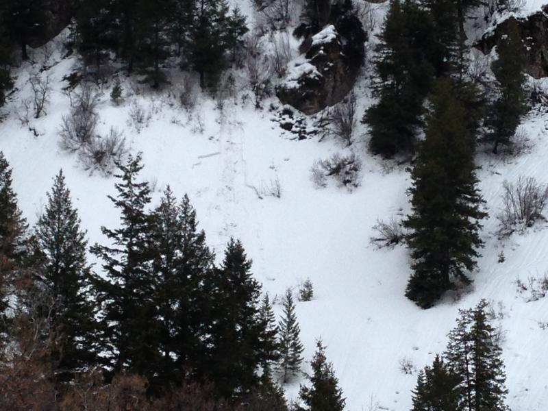
I noticed this wet avalanche in Lower Providence Canyon on Thursday. (2-13-2014)
|
| type | aspect/elevation | characteristics |
|---|

|
|
LIKELIHOOD
 LIKELY
UNLIKELY
SIZE
LARGE
SMALL
TREND
INCREASING DANGER
SAME
DECREASING DANGER
|
|
description
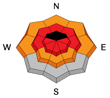
The preexisting snow is shallow and very weak at all elevations, and dangerous triggered persistent slab avalanches failing on buried faceted weak layers are likely today on many steep slopes. Large and long running natural avalanches occurred yesterday and are likely or perhaps occurring again today in some areas, so stay away from and out from under avalanche paths. You could trigger dangerous avalanches remotely, from a distance or even from the flats below steep slopes. As demonstrated yesterday, persistent slab avalanches could entrain wet snow in descent and run down to lower elevations as destructive wet avalanches.
|
| type | aspect/elevation | characteristics |
|---|

|
|
LIKELIHOOD
LIKELY
UNLIKELY
SIZE
 LARGE
SMALL
TREND
 INCREASING DANGER
SAME
DECREASING DANGER
|
|
description
Fresh drifts formed yesterday and overnight in exposed upper elevation terrain. Triggered wind slab avalanches are likely in steep terrain today, and a smaller avalanche overrunning a slope with poor snow structure could cause a step-down into weak old snow and result in a much larger and more dangerous avalanche. Natural avalanches are possible in some areas, so adjust your travel plans accordingly. Stay out from under steep slopes.
|
 |
weather Expect dangerous avalanche conditions in the mountains again today as the moist and mild Pineapple Express resumes, with more snow and rain expected in the mountains. 2 to 4 inches of accumulation is expected at upper elevations, with the rain/snow line gradually creeping up the hill. Temperatures are expected to be around 40 degrees at 8500' today, and will rise further as we head into the weekend. A few more inches of accumulation is possible overnight, with low temperatures in the upper twenties and west wind. Snowfall should cease tomorrow, with cloud cover, and 8500' high temperatures around 46 degrees. Check out our one-stop weather page........HERE |
| general announcements This years CROWBAR Backcountry Ski Race will be held on February 15 at the Sink Hollow Trailhead. The race is officially sanctioned by the U.S. Ski Mountaineering Association, and will be held entirely outside of ski resort boundaries. For a safer powder option; Discount lift tickets are available at Backcountry.com - Thanks to Ski Utah and the Utah Resorts, including Beaver Mountain. All proceeds go towards paying for Utah Avalanche Center avalanche and mountain weather advisories. Utah Avalanche Center mobile app - Get your advisory on your iPhone along with great navigation and rescue tools. Remember your information can save lives. If you see anything we should know about, please participate in the creation of our own community avalanche advisory by submitting snow and avalanche conditions. You can also call us at 801-524-5304 or 800-662-4140, email by clicking HERE, or include #utavy in your tweet or Instagram. Follow us at UAClogan on Twitter I'll issue these advisories on Monday, Wednesday, Friday, and Saturday mornings. This advisory is produced by the U.S.D.A. Forest Service, which is solely responsible for its content. It describes only general avalanche conditions and local variations always exist. |


_1.jpg)