| During the month of April, Mark Miller will donate $75 to the charity of your choice (5 to chose from, including the Utah Avalanche Center!) Mark Miller Subaru has raised over $300k in the previous 6 Do Good Feel Good events. More Info here |  |
| During the month of April, Mark Miller will donate $75 to the charity of your choice (5 to chose from, including the Utah Avalanche Center!) Mark Miller Subaru has raised over $300k in the previous 6 Do Good Feel Good events. More Info here | |
| Advisory: Logan Area Mountains | Issued by Toby Weed for Wednesday - February 12, 2014 - 7:28am |
|---|

|
bottom line There is a CONSIDERABLE or Level 3 avalanche danger in the backcountry. Large and dangerous triggered avalanches are likely and possible on slopes at all elevations and on slopes facing all directions. Dangerous deep slab avalanches could be triggered remotely, from a distance, or the flats below steep slopes. Avalanche conditions will become even more dangerous due to additional heavy snowfall, drifting, and drastically rising temperatures as we head into the weekend. Careful snowpack evaluation, cautious route-finding, and conservative decision making will be essential for safe travel in the backcountry. You may want to change your plans if they involve a trip into the backcountry this weekend.
|
 |
avalanche watch THIS AVALANCHE WATCH IS FOR THE MOUNTAINS AND MOUNTAIN VALLEYS FROM NEAR PROVO THROUGH SALT LAKE, OGDEN AND LOGAN. DEEP, DANGEROUS AND POTENTIALLY UNSURVIVABLE AVALANCHES ARE STILL BEING TRIGGERED BY PEOPLE AND THE DANGER WILL INCREASE DURING AND AFTER THE UPCOMING WET AND WINDY STORM WITH RISING TEMPERATURES. PEOPLE WITHOUT EXPERT LEVEL AVALANCHE TRAINING AND EXPERIENCE SHOULD AVOID BACKCOUNTRY TRAVEL OVER THE NEXT COUPLE OF DAYS. AVOID BEING ON AND BELOW ALL STEEP SLOPES AND WATCH FOR ROOFS TO AVALANCHE AS TEMPERATURES INCREASE. THIS WATCH DOES NOT INCLUDE SKI AREAS OR HIGHWAYS WHERE AVALANCHE CONTROL IS NORMALLY DONE. |
 |
current conditions The Tony Grove Snotel reports 25 degrees and 90 inches of total snow, amazingly now up to 112% of average water content for the date. Dangerous avalanche conditions still exist in the backcountry after this weekend's very productive snowstorm, and another moist storm and significant warming will create a further rising danger as we head into the weekend. Avalanche conditions are unusually bad across the region due to widespread and very weak faceted snow plaguing the basal layers of the snowpack at all elevations and on slopes facing every direction. Backcountry travelers face more dangerous and widespread avalanche conditions than we've seen in years, and we need to be extremely conservative right now.
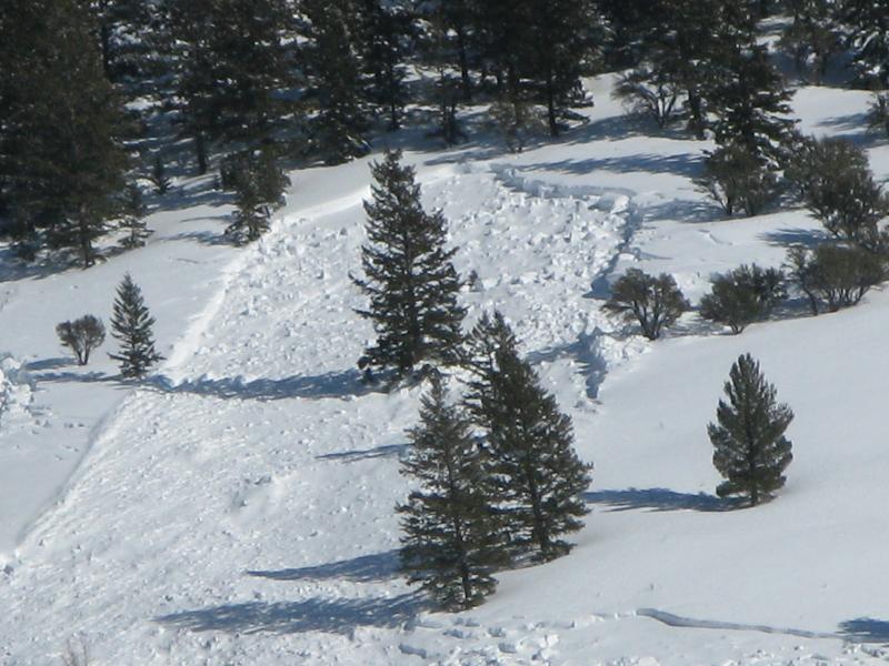
Large natural avalanches in the East Banks area across Logan Canyon from Red Banks Campground. 2-10-2014
|
 |
recent activity
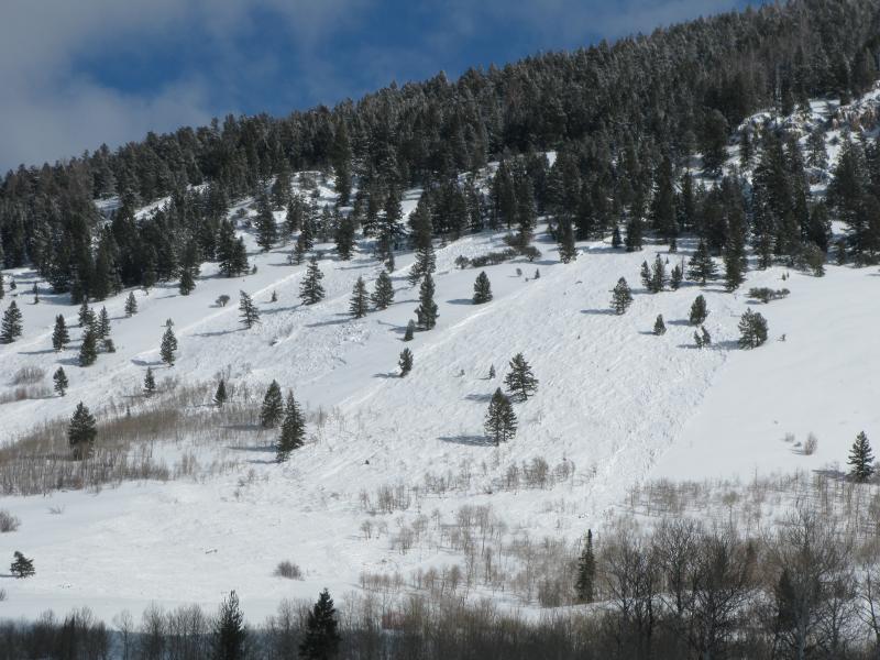
Large natural persistent slab avalanches ran across the Logan Zone over last weekend. This one in Wood Camp. (Pagnucco 2-10-2014) My video observation from Maple Bench, looking at a natural avalanche from Saturday 2-8-2014.....HERE
|
| type | aspect/elevation | characteristics |
|---|

|
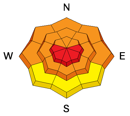
|
LIKELIHOOD
 LIKELY
UNLIKELY
SIZE
 LARGE
SMALL
TREND
 INCREASING DANGER
SAME
DECREASING DANGER
|
|
description
The preexisting snow is shallow and very weak at all elevations, and dangerous triggered persistent slab and/or deep slab avalanches failing on buried faceted weak layers remain likely today on many steep slopes. You could trigger avalanches remotely, from a distance or even from the flats below steep slopes.
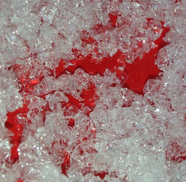
Here's a look at the weak preexisting snow in the Beaver Canyon Area. Photos from 2-2-2014
|
| type | aspect/elevation | characteristics |
|---|

|
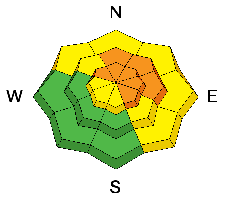
|
LIKELIHOOD
LIKELY
UNLIKELY
SIZE
 LARGE
SMALL
TREND
INCREASING DANGER
SAME
DECREASING DANGER
|
|
description
Fresh drifts formed overnight in exposed upper elevation terrain and will continue to build today. Triggered wind slab avalanches are likely in steep terrain today, and a smaller avalanche over running a slope with poor snow structure could cause a step down into weak old snow and result in a much larger and more dangerous avalanche.
|
| type | aspect/elevation | characteristics |
|---|

|
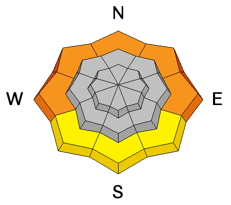
|
LIKELIHOOD
LIKELY
UNLIKELY
SIZE
 LARGE
SMALL
TREND
INCREASING DANGER
SAME
DECREASING DANGER
|
|
description
Rain on the lower elevation snow will quickly re-saturate it, and drastically warming temperatures in the couple days will cause an increasing danger of wet avalanches, initially at lower elevations. Wet slabs and loose moist sluffs entraining significant amounts of fresh snow are possible today in steep lower elevation terrain. Avoid travel above lower elevation terrain traps and stay out from below steep slopes with saturated snow. |
 |
weather Expect dangerous avalanche conditions in the mountains today and the moist Pineapple Express resumes, with snow expected by this afternoon in the mountains. 3 to 7 inches of accumulation is expected with intensifying and strong southwest wind. Temperatures are expected to be a bit above freezing at 8500' today, and will rise significantly as we head into the weekend. Strong southwest wind and continued heavy snowfall is expected tonight and through tomorrow, with an additional 10 to 20 inches of accumulation possible and warming temperatures...... Check out our one-stop weather page........HERE |
| general announcements This years CROWBAR Backcountry Ski Race will be held on February 15 at the Sink Hollow Trailhead. The race is officially sanctioned by the U.S. Ski Mountaineering Association, and will be held entirely outside of ski resort boundaries. For a safer powder option; Discount lift tickets are available at Backcountry.com - Thanks to Ski Utah and the Utah Resorts, including Beaver Mountain. All proceeds go towards paying for Utah Avalanche Center avalanche and mountain weather advisories. Utah Avalanche Center mobile app - Get your advisory on your iPhone along with great navigation and rescue tools. Remember your information can save lives. If you see anything we should know about, please participate in the creation of our own community avalanche advisory by submitting snow and avalanche conditions. You can also call us at 801-524-5304 or 800-662-4140, email by clicking HERE, or include #utavy in your tweet or Instagram. Follow us at UAClogan on Twitter I'll issue these advisories on Monday, Wednesday, Friday, and Saturday mornings. This advisory is produced by the U.S.D.A. Forest Service, which is solely responsible for its content. It describes only general avalanche conditions and local variations always exist. |


_1.jpg)