| During the month of April, Mark Miller will donate $75 to the charity of your choice (5 to chose from, including the Utah Avalanche Center!) Mark Miller Subaru has raised over $300k in the previous 6 Do Good Feel Good events. More Info here |  |
| During the month of April, Mark Miller will donate $75 to the charity of your choice (5 to chose from, including the Utah Avalanche Center!) Mark Miller Subaru has raised over $300k in the previous 6 Do Good Feel Good events. More Info here | |
| Advisory: Logan Area Mountains | Issued by Toby Weed for Monday - February 10, 2014 - 7:20am |
|---|

|
bottom line There is a HIGH or Level 4 avalanche danger in the backcountry. Large natural avalanches are likely. Dangerous deep slab avalanches could be triggered remotely, from a distance, or the flats below steep slopes. Change your plans. Avoid all travel in avalanche terrain. Stay off of and out from under steep slopes and well clear of obvious or historic avalanche paths..
|
 |
avalanche warning THIS AVALANCHE WARNING IS FOR ALL MOUNTAINS OF NORTHERN AND CENTRAL UTAH, SOUTHEAST IDAHO... THE LARGEST SNOWSTORM OF THE WINTER HAS OVERLOADED A VERY WEAK PRE-EXISTING SNOWPACK, WHICH HAS CAUSED WIDESPREAD, LARGE AVALANCHES AND TWO FATALITIES OVER THE WEEKEND. A HIGH DANGER CONTINUES FOR ALL ASPECTS AND ELEVATIONS. THIS WARNING DOES NOT INCLUDE SKI AREAS OR HIGHWAYS WHERE AVALANCHE CONTROL IS NORMALLY DONE. |
 |
current conditions A couple more feet of snow fell over the weekend at upper elevations, sustained west winds caused significant drifting, temperatures warmed, lots of rain fell down low, and the snow in the mountains around Logan came unglued. Logan Canyon is closed due to continued avalanche risk after being hit by several large avalanches yesterday morning. UDOT crews will reassess the situation to see if it can be reopened this morning. The Tony Grove Snotel reports 26 degrees and 93 inches of total snow with a couple feet of new snow and 6.7" of water since early Friday morning. Warming caused the snow to be inverted, or heavier on top. West southwest winds continued overnight. Travel in the very deep snow is difficult due to the depth and weight. Trail breaking is arduous, and sleds will sink right into deep snow if you leave the packed trail. But, very dangerous avalanche conditions exist in the backcountry, and you should change your plans anyway. At least avoid and stay well out from under all steep slopes and obvious or historic avalanche paths.
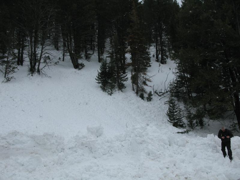
Large natural avalanches and the threat of continued activity closed Hwy 89 in Logan Canyon yesterday. 2-9-2014
|
 |
recent activity Sadly, avalanches killed two Utah residents over the weekend. See our reports as they become available HERE. Hundreds of natural and triggered avalanches occurred across Utah yesterday, many were reported to the UAC. It was a very active day. Check out our observations page Locally: Logan Canyon was hit several times yesterday morning by both wet slab and deep slab avalanches originating a lower elevations. The Canyon remains closed this morning. SEE PHOTOS HERE. Large and long-running natural avalanches ran on the east side of the Wellsville Range all weekend and were reported in the Mt. Naomi Wilderness, wet avalanches were observed on Little Mountain and in Green Canyon, large natural avalanches hit the road to Powder Mountain, and more significant natural activity is possible today.
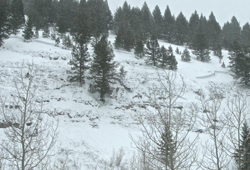
Large natural wet slab avalanches ran in Logan Canyon yesterday morning. This one stopped before hitting the road. 2-9-2014 My video observation from Maple Bench, looking at a natural avalanche from Saturday 2-8-2014.....HERE
|
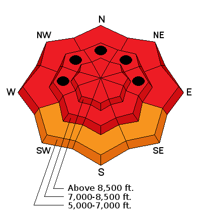
| type | aspect/elevation | characteristics |
|---|

|
|
LIKELIHOOD
 LIKELY
UNLIKELY
SIZE
 LARGE
SMALL
TREND
 INCREASING DANGER
SAME
DECREASING DANGER
|
|
description
The preexisting snow is shallow and very weak at all elevations, and dangerous triggered persistent slab and/or deep slab avalanches failing on buried faceted weak layers are likely today on many steep slopes. You could trigger avalanches remotely, from a distance or even from the flats below steep slopes. Large natural avalanches are likely and many occurred yesterday, so you should stay clear of all avalanche runout zones and off of and out from under all steep slopes.
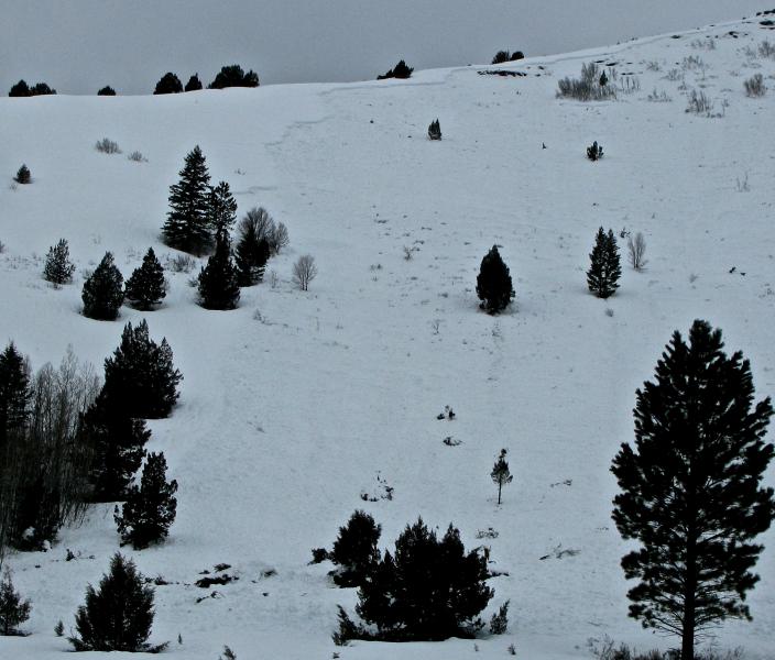
Here's a look at the weak preexisting snow in the Beaver Canyon Area. Photos from 2-2-2014
|
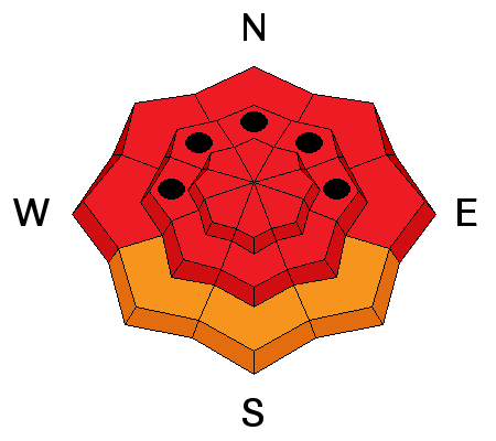
| type | aspect/elevation | characteristics |
|---|

|
|
LIKELIHOOD
LIKELY
UNLIKELY
SIZE
 LARGE
SMALL
TREND
INCREASING DANGER
SAME
DECREASING DANGER
|
|
description
Large natural storm snow and wind slab avalanches are likely in steep terrain today.
|
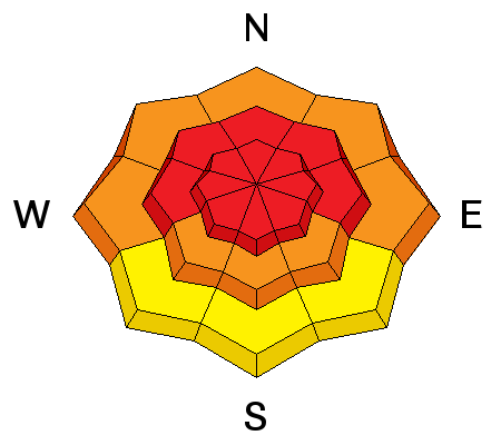
| type | aspect/elevation | characteristics |
|---|

|
|
LIKELIHOOD
 LIKELY
UNLIKELY
SIZE
 LARGE
SMALL
TREND
 INCREASING DANGER
SAME
DECREASING DANGER
|
|
description
Rain on all the fresh snow created a significant danger of wet avalanches at lower elevations. Wet slabs and loose moist sluffs entraining significant amounts of fresh snow are likely and occurring in steep lower elevation terrain. Avoid lower elevation terrain traps (and the river) below steep slopes with saturated snow. |
 |
weather Expect very dangerous avalanche conditions in the mountains today. A bit more snow will fall this morning before tapering to showers, with an inch or two of additional accumulation possible. 8500' temperatures will be a bit cooler today, around 25 degrees. Expect light to moderate north northwest wind on the ridges. Looks like we'll get a bit of a break in the weather today and Tuesday before the moist Pineapple Express resumes late Wednesday. Check out our one-stop weather page........HERE |
| general announcements This years CROWBAR Backcountry Ski Race will be held on February 15 at the Sink Hollow Trailhead. The race is officially sanctioned by the U.S. Ski Mountaineering Association, and will be held entirely outside of ski resort boundaries. For a safer powder option; Discount lift tickets are available at Backcountry.com - Thanks to Ski Utah and the Utah Resorts, including Beaver Mountain. All proceeds go towards paying for Utah Avalanche Center avalanche and mountain weather advisories. Utah Avalanche Center mobile app - Get your advisory on your iPhone along with great navigation and rescue tools. Remember your information can save lives. If you see anything we should know about, please participate in the creation of our own community avalanche advisory by submitting snow and avalanche conditions. You can also call us at 801-524-5304 or 800-662-4140, email by clicking HERE, or include #utavy in your tweet or Instagram. Follow us at UAClogan on Twitter I'll issue these advisories on Monday, Wednesday, Friday, and Saturday mornings. This advisory is produced by the U.S.D.A. Forest Service, which is solely responsible for its content. It describes only general avalanche conditions and local variations always exist. |


_1.jpg)