
| During the month of April, Mark Miller will donate $75 to the charity of your choice (5 to chose from, including the Utah Avalanche Center!) Mark Miller Subaru has raised over $300k in the previous 6 Do Good Feel Good events. More Info here |  |
| During the month of April, Mark Miller will donate $75 to the charity of your choice (5 to chose from, including the Utah Avalanche Center!) Mark Miller Subaru has raised over $300k in the previous 6 Do Good Feel Good events. More Info here | |
| Advisory: Logan Area Mountains | Issued by Toby Weed for Sunday - February 9, 2014 - 7:16am |
|---|

|
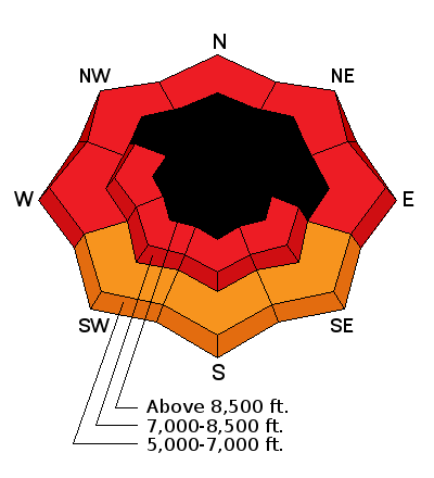
bottom line There is an EXTREME or Level 5 avalanche danger in the backcountry, with continuing heavy snowfall, strong southwest winds, and rising temperatures. Large natural avalanches are likely and/or ongoing today. Dangerous deep slab avalanches could be triggered remotely, from a distance, or the flats below steep slopes. Avoid all travel in avalanche terrain. Stay off of and out from under steep slopes and well clear of obvious or historic avalanche paths..
|
 |
avalanche warning AVALANCHE WARNING CONTINUES FOR ALL THE MOUNTAINS OF NORTHERN AND CENTRAL UTAH...SOUTHEAST IDAHO...THE WESTERN UINTAS...AND SOUTH TO THE MANTI-SKYLINE PLATEAU TO I-70. HEAVY SNOW AND WIND HAS PUSHED THE AVALANCHE DANGER TO HIGH, BORDERING ON EXTREME. AVOID BACKCOUNTRY TRAVEL ALTOGETHER...AS LARGE NATURAL AND HUMAN TRIGGERED AVALANCHES REMAIN LIKELY IN MANY AREAS ACROSS THE STATE. THIS WARNING DOES NOT INCLUDE SKI AREAS OR HIGHWAYS WHERE AVALANCHE CONTROL IS NORMALLY DONE. |
 |
current conditions A couple more feet of snow fell yesterday and overnight at upper elevations, and warming temperatures turned the nice powder from the week upside down. The Tony Grove Snotel reports 93 inches total with a couple feet of new snow and 6" of water since early Friday morning. The snow is inverted, or heavier on top. Southwest winds picked up significantly yesterday and were cranking all night, with the 9700' CSI Logan Peak weather station is rimed or iced over again this morning, but the UDOT Hwy 89 Logan Summit station reports overnight average wind speeds of around 30 mph, with a 52 mph gust early this morning. Travel in the very deep snow is very difficult, but very dangerous avalanche conditions exist and you should avoid and stay well out from under all steep slopes and avalanche paths. My video observation from Beaver Backside from Friday 2-7-2014.....HERE
|
 |
recent activity Locally: Large and long-running natural avalanches ran on the east side of the Wellsville Range, wet avalanches were observed on Little Mountain, large natural avalanches from overnight hit the road to Powder Mountain, and more significant natural activity is likely to occur today.
Large natural avalanches ran on the east side of the Wellsville Range above Mendon. This one hit Maple Bench below Old Logway Canyon. 2-8-2014
|
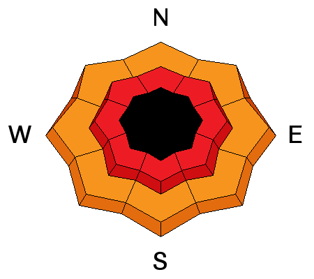
| type | aspect/elevation | characteristics |
|---|

|
|
LIKELIHOOD
 LIKELY
UNLIKELY
SIZE
 LARGE
SMALL
TREND
 INCREASING DANGER
SAME
DECREASING DANGER
|
|
description
Large natural storm snow and wind slab avalanches are likely or ongoing in steep terrain today.
|
| type | aspect/elevation | characteristics |
|---|

|
|
LIKELIHOOD
 LIKELY
UNLIKELY
SIZE
 LARGE
SMALL
TREND
 INCREASING DANGER
SAME
DECREASING DANGER
|
|
description
In areas where the preexisting snow is shallow it is very weak, and dangerous triggered persistent slab and/or deep slab avalanches failing on buried faceted weak layers are likely on many steep slopes. You could trigger avalanches remotely, from a distance or even from the flats below steep slopes. Large natural avalanches are likely and occurring currently, so stay clear of avalanche runout zones and off of and out from under all steep slopes.
|
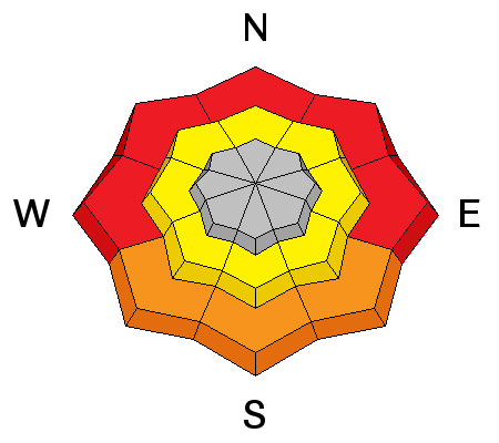
| type | aspect/elevation | characteristics |
|---|

|
|
LIKELIHOOD
LIKELY
UNLIKELY
SIZE
 LARGE
SMALL
TREND
INCREASING DANGER
SAME
DECREASING DANGER
|
|
description
Rain on all the fresh snow created a significant danger of wet avalanches at lower elevations. Wet slabs and loose moist sluffs entraining significant amounts of fresh snow are likely and occurring in steep lower elevation terrain. Avoid lower elevation terrain traps (and the river) below steep slopes with saturated snow. |
 |
weather Expect very dangerous and extreme avalanche conditions in the mountains today and continued serious winter weather, with somewhat warmer temperatures and rain continuing in the Valley, 3 to 5 inches of snow, and sustained moderate west winds. 8500' temperatures will be a bit above freezing, and it'll be warmer below. Looks like we'll get a bit of a break in the weather tomorrow and Tuesday before the moist Pineapple Express resumes. Check out our one-stop weather page........HERE |
| general announcements This years CROWBAR Backcountry Ski Race will be held on February 15 at the Sink Hollow Trailhead. The race is officially sanctioned by the U.S. Ski Mountaineering Association, and will be held entirely outside of ski resort boundaries. For a safer powder option; Discount lift tickets are available at Backcountry.com - Thanks to Ski Utah and the Utah Resorts, including Beaver Mountain. All proceeds go towards paying for Utah Avalanche Center avalanche and mountain weather advisories. Utah Avalanche Center mobile app - Get your advisory on your iPhone along with great navigation and rescue tools. Remember your information can save lives. If you see anything we should know about, please participate in the creation of our own community avalanche advisory by submitting snow and avalanche conditions. You can also call us at 801-524-5304 or 800-662-4140, email by clicking HERE, or include #utavy in your tweet or Instagram. Follow us at UAClogan on Twitter I'll issue these advisories on Monday, Wednesday, Friday, and Saturday mornings. This advisory is produced by the U.S.D.A. Forest Service, which is solely responsible for its content. It describes only general avalanche conditions and local variations always exist. |


_1.jpg)


