
| During the month of April, Mark Miller will donate $75 to the charity of your choice (5 to chose from, including the Utah Avalanche Center!) Mark Miller Subaru has raised over $300k in the previous 6 Do Good Feel Good events. More Info here |  |
| During the month of April, Mark Miller will donate $75 to the charity of your choice (5 to chose from, including the Utah Avalanche Center!) Mark Miller Subaru has raised over $300k in the previous 6 Do Good Feel Good events. More Info here | |
| Advisory: Logan Area Mountains | Issued by Toby Weed for Saturday - February 8, 2014 - 5:30pm |
|---|


|
bottom line There is a HIGH or Level 4 avalanche danger in the backcountry already this morning, and the danger will continue to rise and become more widespread with continuing heavy snowfall, strong southwest winds, and gradually rising temperatures. Natural and human triggered avalanches are likely. The danger could rise to EXTREME or Level 5 in some drifted terrain this afternoon, with large natural avalanches almost a given overnight. Dangerous persistent slab avalanches are increasingly likely, and might be triggered remotely, from a distance, or the flats below steep slopes. Avoid all travel in avalanche terrain. Stay off of and out from under steep slopes and well clear of obvious or historic avalanche paths..
|
 |
avalanche warning THIS AVALANCHE WARNING IS FOR ALL THE MOUNTAINS OF NORTHERN AND CENTRAL UTAH...SOUTHEAST IDAHO...THE WESTERN UINTAS...AND SOUTH TO THE MANTI-SKYLINE PLATEAU. HEAVY SNOW AND STRONG WINDS HAS LED TO A HIGH AVALANCHE DANGER, BORDERING ON EXTREME IN LOCALIZED AREAS. VERY DANGEROUS AVALANCHE CONDITIONS EXIST. LONGER RUNNING NATURAL AVALANCHES MAY BE EXPECTED OVER THE WEEKEND. LARGE AVALANCHES MAY BE TRIGGERED ON AND FROM WELL BELOW STEEP TERRAIN...BACKCOUNTRY TRAVEL IS NOT RECOMMENDED. THIS WARNING DOES NOT INCLUDE SKI AREAS OR HIGHWAYS WHERE AVALANCHE CONTROL IS NORMALLY DONE. |
 |
special announcement The Essential Avalanche and Riding Skills Workshop scheduled for today Saturday Feb 8 HAS BEEN POSTPONED. We will post a new date as soon as possible. Call 435-757-2794 for more information. |
 |
current conditions A couple more feet of snow fell yesterday and overnight at upper elevations, and warming temperatures turned the nice powder from the week upside down. Before we lost contact at 7:00 last night, the Tony Grove Snotel reported 82 inches total with another foot of new snow and 2" of water in the last 24 hours. The snow is inverted, or heavier on top. Southwest winds picked up significantly yesterday and were cranking last night, with the 9700' CSI Logan Peak weather station reporting overnight average wind speeds of around 30 mph, with a 60 mph gust early this morning. Very dangerous avalanche conditions exist and you should avoid and stay well out from under all steep slopes and avalanche paths.
This morning's 4km Water vapor imagery.
|
 |
recent activity We recorded a total of 6 people being caught and carried by avalanches in the Wasatch backcountry during the week. The avalanches were apparently somewhat forgiving. Locally; I noticed a couple small triggered soft slabs as I was driving by the lower backside area yesterday evening. Natural avalanches from overnight are visible this morning in the Powder Mountain Area. Large and long-running natural avalanches ran down to Maple Bench and in other large avalanche paths on the east side of the Wellsville Range, and more natural activity is likely tonight and tomorrow. My video observation from Beaver Backside yesterday afternoon.....HERE
|
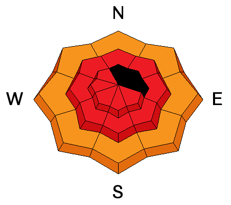
| type | aspect/elevation | characteristics |
|---|

|
|
LIKELIHOOD
 LIKELY
UNLIKELY
SIZE
 LARGE
SMALL
TREND
 INCREASING DANGER
SAME
DECREASING DANGER
|
|
description
Dangerous soft slab conditions exist, and continued heavy snowfall and drifting will cause the danger to increase further and become more widespread. You are likely to trigger wind slab avalanches 2 to 3 feet deep, failing on weaker layers within the fresher snow or the sugary old snow surface from last week in steep drifted terrain, especially in upper elevation lee slope areas. Natural storm snow and wind slab avalanches are also likely in steep terrain today, tonight, and tomorrow..
|
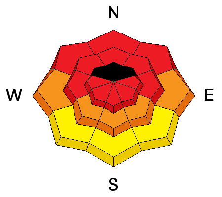
| type | aspect/elevation | characteristics |
|---|

|
|
LIKELIHOOD
 LIKELY
UNLIKELY
SIZE
LARGE
SMALL
TREND
INCREASING DANGER
SAME
DECREASING DANGER
|
|
description
The danger of persistent slab avalanches will continue to rise with the intensifying storm currently upon us. In areas where the preexisting snow is shallow it is very weak, and dangerous triggered persistent slab and/or deep slab avalanches failing on buried faceted weak layers are possible on some steep slopes. You could trigger avalanches remotely, from a distance or even from the flats below steep slopes. Large natural avalanches are likely this weekend, so stay clear of avalanche runout zones and out from under all steep slopes. The danger in some upper elevations areas could rise to EXTREME by this afternoon, and I would bet my sled that significant natural activity will occur overnight. Trent Meisenheimer released a great video last week about persistent slab avalanches. View it ...HERE
|
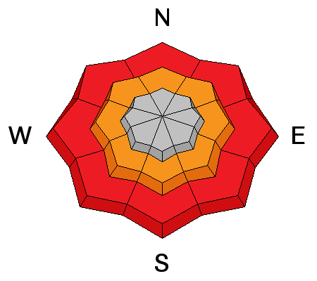
| type | aspect/elevation | characteristics |
|---|

|
|
LIKELIHOOD
 LIKELY
UNLIKELY
SIZE
 LARGE
SMALL
TREND
INCREASING DANGER
SAME
DECREASING DANGER
|
|
description
A rising rain/snow line today will further complicate the situation. Rain on all the fresh snow could create a significant danger of wet avalanches at lower elevations. Wet slabs and loose moist sluffs entraining significant amounts of fresh snow will become likely in steep terrain. Avoid terrain traps and the river below steep slopes and stay off of steep slopes where you might be swept into trees or rocks below. |
 |
weather Expect dangerous avalanche conditions today and continued serious winter weather, with somewhat warmer temperatures, 8 to 12 inches of snow and sustained moderate southwest winds. 8500' temperatures will be around freezing, but warmer below. Another 8 to 12 inches of accumulation is expected overnight. Check out our one-stop weather page........HERE |
| general announcements This years CROWBAR Backcountry Ski Race will be held on February 15 at the Sink Hollow Trailhead. The race is officially sanctioned by the U.S. Ski Mountaineering Association, and will be held entirely outside of ski resort boundaries. For a safer powder option; Discount lift tickets are available at Backcountry.com - Thanks to Ski Utah and the Utah Resorts, including Beaver Mountain. All proceeds go towards paying for Utah Avalanche Center avalanche and mountain weather advisories. Utah Avalanche Center mobile app - Get your advisory on your iPhone along with great navigation and rescue tools. Remember your information can save lives. If you see anything we should know about, please participate in the creation of our own community avalanche advisory by submitting snow and avalanche conditions. You can also call us at 801-524-5304 or 800-662-4140, email by clicking HERE, or include #utavy in your tweet or Instagram. Follow us at UAClogan on Twitter I'll issue these advisories on Monday, Wednesday, Friday, and Saturday mornings. This advisory is produced by the U.S.D.A. Forest Service, which is solely responsible for its content. It describes only general avalanche conditions and local variations always exist. |


_1.jpg)
