| During the month of April, Mark Miller will donate $75 to the charity of your choice (5 to chose from, including the Utah Avalanche Center!) Mark Miller Subaru has raised over $300k in the previous 6 Do Good Feel Good events. More Info here |  |
| During the month of April, Mark Miller will donate $75 to the charity of your choice (5 to chose from, including the Utah Avalanche Center!) Mark Miller Subaru has raised over $300k in the previous 6 Do Good Feel Good events. More Info here | |
| Advisory: Logan Area Mountains | Issued by Toby Weed for Friday - February 7, 2014 - 6:25am |
|---|

|
bottom line Expect a rising avalanche danger in the backcountry with increasingly heavy snowfall, intensifying west winds, and gradually rising temperatures. Dangerous avalanche conditions and a Level 3 or CONSIDERABLE danger already exist this morning on some drifted upper and mid elevation slopes, and the danger will continue to rise and become more widespread as we head into the weekend. Expect a HIGH or Level 4 danger to develop in some drifted terrain this afternoon, with large natural avalanches possible overnight. Avoid travel in avalanche terrain, we recommend that you avoid and stay out from under steep slopes and obvious of historic avalanche paths..
|
 |
avalanche warning EXPECTED SNOW AND WIND FRIDAY THROUGH THE WEEKEND WILL CREATE DANGEROUS AVALANCHE CONDITIONS. THE WARNING BEGINS IN THE SOUTHEAST IDAHO, LOGAN, AND OGDEN AREA MOUNTAINS TODAY AND THE WASATCH RANGE, UINTA MOUNTAINS AND MANTI SKYLINE TONIGHT. DANGEROUS AVALANCHE CONDITIONS SHOULD PERSIST THROUGH THE WEEKEND. THIS WARNING DOES NOT INCLUDE SKI AREAS OR HIGHWAYS WHERE AVALANCHE CONTROL IS NORMALLY DONE. |
 |
special announcement The Essential Avalanche and Riding Skills Workshop scheduled for this Saturday Feb 8 HAS BEEN POSTPONED. We will post a new date as soon as possible. Call 435-757-2794 for more information. |
 |
current conditions The Tony Grove Snotel reports 8 more inches of light new snow in the last 24 hours containing 7/10ths of an inch of water. There's 75 inches of total snow, and this mornings temperature readings are already more than 10 degrees warmer than yesterday's, it's 21 degrees at 8400' . It's 14 degrees at the 9700' Logan Peak weather station, southwest winds are intensifying, with a 40 mph gust just a few minutes ago . The wind on Mt Ogden increased overnight as well, and is from the southwest, averaging around 30 mph with gusts above 50 mph this morning. Observers report excellent powder conditions from the backcountry yesterday. Unfortunately, we can expect increasingly heavy snowfall, intensifying west winds, and gradually rising temperatures, which is already turning the snow upside down and creating rising and dangerous avalanche conditions as we head into the weekend.
We can expect increasingly heavy snowfall, intensifying west winds, and gradually rising temperatures. This morning's 4km water vapor satellite image.
|
 |
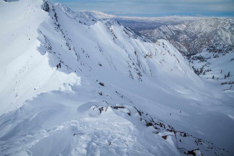
recent activity Locally; We noticed a fair amount of natural sluffing and some small soft slab activity in steep terrain over the last few days, but overall, the light powder has been well behaved. With this weekend's storm upon us, the nice snow is a thing of the past though and it will rapidly become dangerous today. There were a number of triggered (apparently somewhat forgiving) avalanches in the Central Wasatch backcountry Wednesday and another yesterday, with at least 5 and perhaps 8 people caught and carried by avalanches they triggered, but thankfully and luckily no reported injuries. We don't like it much when two or three people get caught by the same avalanche. Thankfully, we can all learn from these incidents, and nobody had to get hurt. Check out our Observations Page...
An avalanche in the Central Wasatch Range that caught and carried two backcountry skiers yesterday. (2-5-2014)
|
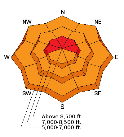
| type | aspect/elevation | characteristics |
|---|

|

|
LIKELIHOOD
 LIKELY
UNLIKELY
SIZE
 LARGE
SMALL
TREND
 INCREASING DANGER
SAME
DECREASING DANGER
|
|
description
The fresh snow from the last couple days and overnight is light and fluffy, and it won't take much wind to cause significant drifting. West winds increased overnight and will continue to pick up steam today and tonight. Dangerous soft wind slab conditions may already exist in some areas, and drifting will cause the danger to increase and become more widespread. You are likely to trigger wind slab avalanches up to around 2 feet deep, failing on weaker layers within the fresher snow or the sugary old snow surface from last week in steep drifted terrain, especially in upper elevation lee slope areas. Also, watch for and avoid stiffer wind deposited snow in and around terrain features like gullies, scoops, sub-ridges, and rock outcroppings or cliff bands at upper and mid elevations and on slopes facing all directions.. The danger will rise to HIGH in some areas this afternoon, with significant natural avalanches possible overnight.
|
| type | aspect/elevation | characteristics |
|---|

|
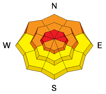
|
LIKELIHOOD
LIKELY
UNLIKELY
SIZE
 LARGE
SMALL
TREND
INCREASING DANGER
SAME
DECREASING DANGER
|
|
description
The danger of persistent slab avalanches will continue to rise with the intensifying storm currently upon us. In areas where the preexisting snow is shallow it is very weak, and dangerous triggered persistent slab and/or deep slab avalanches failing on buried faceted weak layers are possible on some steep slopes. Persistent slab activity was observed locally at upper elevations last weekend, and chances are good that more slopes could be hanging in a state of balance with the fresh load from the last couple days. In some areas you could trigger avalanches remotely, from a distance or even from the flats below steep slopes. Large natural avalanches are possible this weekend, so stay clear of avalanche runout zones and out from under steep slopes. Trent Meisenheimer released a great video last week about persistent slab avalanches. View it ...HERE
|
| type | aspect/elevation | characteristics |
|---|

|
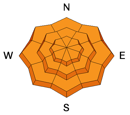
|
LIKELIHOOD
LIKELY
UNLIKELY
SIZE
LARGE
SMALL
TREND
INCREASING DANGER
SAME
DECREASING DANGER
|
|
description
With all new powdery snow piling up and increasing snow densities due to gradually warming temperatures, expect to find the fresh snow inverted or upside down, heavier in the upper layers. Soft storm slabs and loose sluffs entraining significant amounts of fresh snow are likely in steep terrain. Avoid terrain traps and steep slopes where you might be swept into trees or rocks below. |
 |
weather Expect dangerous avalanche conditions today and some serious winter weather, with somewhat warmer temperatures, 6 to 10 inches of snow and even stronger west winds, 25 to 35 mph, with gusts in the mid fifties. Another 4 to 8 inches of accumulation is expected overnight, with west southwest winds even a little stronger. The storm will continue with some strength through the weekend and beyond, with gradually warming temperatures through Sunday and then decreasing again. Check out our one-stop weather page........HERE |
| general announcements This years CROWBAR Backcountry Ski Race will be held on February 15 at the Sink Hollow Trailhead. The race is officially sanctioned by the U.S. Ski Mountaineering Association, and will be held entirely outside of ski resort boundaries. For a safer powder option; Discount lift tickets are available at Backcountry.com - Thanks to Ski Utah and the Utah Resorts, including Beaver Mountain. All proceeds go towards paying for Utah Avalanche Center avalanche and mountain weather advisories. Utah Avalanche Center mobile app - Get your advisory on your iPhone along with great navigation and rescue tools. Remember your information can save lives. If you see anything we should know about, please participate in the creation of our own community avalanche advisory by submitting snow and avalanche conditions. You can also call us at 801-524-5304 or 800-662-4140, email by clicking HERE, or include #utavy in your tweet or Instagram. Follow us at UAClogan on Twitter I'll issue these advisories on Monday, Wednesday, Friday, and Saturday mornings. This advisory is produced by the U.S.D.A. Forest Service, which is solely responsible for its content. It describes only general avalanche conditions and local variations always exist. |


_1.jpg)