| During the month of April, Mark Miller will donate $75 to the charity of your choice (5 to chose from, including the Utah Avalanche Center!) Mark Miller Subaru has raised over $300k in the previous 6 Do Good Feel Good events. More Info here |  |
| During the month of April, Mark Miller will donate $75 to the charity of your choice (5 to chose from, including the Utah Avalanche Center!) Mark Miller Subaru has raised over $300k in the previous 6 Do Good Feel Good events. More Info here | |
| Advisory: Logan Area Mountains | Issued by Toby Weed for Friday - January 31, 2014 - 6:33am |
|---|

|
bottom line Dangerous avalanche conditions exist, and there is a Level 3 or CONSIDERABLE danger on steep drifted slopes in the backcountry. Triggered wind slab avalanches 1 to 2 feet deep are probable on steep slopes with significant deposits of drifted snow. More dangerous and potentially destructive persistent slab avalanches, stepping down into weak faceted old snow, are possible and might be triggered remotely, from a distance, or the flats below steep slopes. Careful snowpack evaluation, cautious route-finding, and conservative decision making will be essential for safe travel in the backcountry this weekend.
|
 |
current conditions The Tony Grove Snotel at 8400' reports about 15 inches of very heavy new snow in the last 48 hours, containing 2.6" of water. It's 13 degrees and there's 59 inches of total snow containing 81% of average water content for the date. It's 8 degrees at the 9700' Logan Peak weather station, and the wind sensor is rimed or incrusted by ice. I'm currently reading light easterly winds up at the UDOT Hwy 89 Logan Summit weather station. We did not dare venture into steep avalanche terrain yesterday, but found good smooth and supportable riding conditions in the Tony Grove Area, floating on top of the heavy new snow. Trail breaking was fairly easy due to good floatation on both skis and on a sled. We encountered heavy snowfall at times, and substantial drifting quickly filled in and erased our tracks in exposed areas.
|
 |
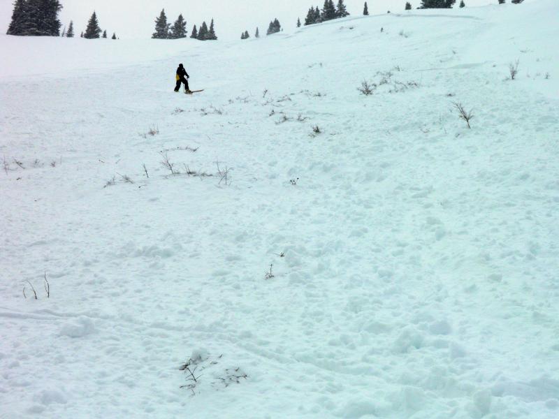
recent activity Backcountry skiers triggered a couple nice soft slab avalanches in the Central Wasatch Range yesterday. Locally; other than expected wet activity at low elevations in Logan Canyon due to Wednesday's rain, no new avalanches have been reported since January 17, when a local rider experienced a close call with a large persistent slab avalanche at Bloomington Lake, north of the state line up in southeast Idaho.
Skier triggered avalanche from yesterday in the Central Wasatch Range. Report HERE. (White)
|
| type | aspect/elevation | characteristics |
|---|

|
|
LIKELIHOOD
 LIKELY
UNLIKELY
SIZE
 LARGE
SMALL
TREND
 INCREASING DANGER
SAME
DECREASING DANGER
|
|
description
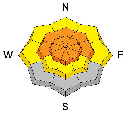
I'm not sure if the over 2.5" of water weight in the 15 inches of heavy new snow from Wednesday and yesterday is enough to reactivate the widespread very weak faceted layers and depth hoar that plague all elevations in the Logan Zone, but along with some serious drifting it could be more than enough in some areas. In these areas, dangerous triggered persistent slab and/or deep slab avalanches failing on buried faceted weak layers are possible on steep slopes. You might trigger large and destructive avalanches remotely, from a distance or even from the flats below steep slopes. Trent Meisenheimer just released a great video about persistent slab avalanches.....HERE
|
| type | aspect/elevation | characteristics |
|---|

|
|
LIKELIHOOD
 LIKELY
UNLIKELY
SIZE
 LARGE
SMALL
TREND
 INCREASING DANGER
SAME
DECREASING DANGER
|
|
description
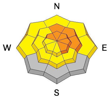
Fresh wind slabs 1 to 2 feet deep, failing on the old snow surface are probable in some drifted terrain, especially in upper elevation lee slope areas. But also watch for and avoid stiffer wind deposited snow in and around terrain features like gullies, scoops, sub-ridges, and rock bands or cliffs at all elevations and on slopes facing all directions..
|
 |
weather Cool, unsettled weather and a northwest flow will continue through tomorrow in the mountains, but not much in the way of additional accumulation is expected. There's a chance of snow today, mainly in the afternoon, with 1 to 2 inches of accumulation possible, 8500' high temperatures will get up to around 20 degrees, with sub zero wind chills possible due to a continuing moderate west wind. Temperatures will drop to around 8 degrees overnight, with another 1 to 2 inches of accumulation possible. Could see a bit more snow tomorrow, with increasing west winds and temperatures down in the teens. 2 to 4 inches of accumulation from lingering instability showers is the best guess for Saturday, but confidence is low in the snow forecast, with much less accumulation or up to 6 to 10 inches possible. Check out our one-stop weather page........HERE |
| general announcements For a safer powder option; Discount lift tickets are available at Backcountry.com - Thanks to Ski Utah and the Utah Resorts, including Beaver Mountain. All proceeds go towards paying for Utah Avalanche Center avalanche and mountain weather advisories. Utah Avalanche Center mobile app - Get your advisory on your iPhone along with great navigation and rescue tools. Remember your information can save lives. If you see anything we should know about, please participate in the creation of our own community avalanche advisory by submitting snow and avalanche conditions. You can also call us at 801-524-5304 or 800-662-4140, email by clicking HERE, or include #utavy in your tweet or Instagram. Follow us at UAClogan on Twitter I'll issue these advisories on Monday, Wednesday, Friday, and Saturday mornings. This advisory is produced by the U.S.D.A. Forest Service, which is solely responsible for its content. It describes only general avalanche conditions and local variations always exist. |


_1.jpg)