
| During the month of April, Mark Miller will donate $75 to the charity of your choice (5 to chose from, including the Utah Avalanche Center!) Mark Miller Subaru has raised over $300k in the previous 6 Do Good Feel Good events. More Info here |  |
| During the month of April, Mark Miller will donate $75 to the charity of your choice (5 to chose from, including the Utah Avalanche Center!) Mark Miller Subaru has raised over $300k in the previous 6 Do Good Feel Good events. More Info here | |
| Advisory: Logan Area Mountains | Issued by Toby Weed for Thursday - January 30, 2014 - 7:00am |
|---|

|
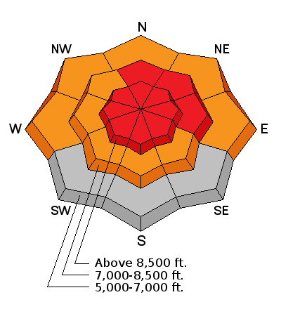
bottom line There is a HIGH or Level 4 danger on drifted slopes at upper elevations in the backcountry today. Very dangerous persistent slab avalanches are possible and could be triggered remotely, from a distance or the flats below steep slopes. Storm snow and wind slab avalanches are also likely on steep slopes with significant deposits of drifted heavy new snow. Dangerous wet avalanche conditions exist at mid and lower elevations on steep slopes with rain saturated snow. Avoid travel today on or beneath steep drifted slopes, slopes with saturated snow, and obvious or historic avalanche paths.
|
 |
avalanche warning THIS AVALANCHE WARNING IS FOR THE WASATCH MOUNTAINS FROM I-80 NORTH INCLUDING THE BEAR RIVER RANGE. HEAVY SNOW AND STRONG WINDS HAVE OVERLOADED PREEXISTING WEAK SNOW. DANGEROUS HUMAN TRIGGERED AND NATURAL AVALANCHES ARE POSSIBLE. AVOID TRAVEL ON AND BELOW STEEP SLOPES AND BENEATH OBVIOUS OR HISTORICAL AVALANCHE PATHS. THIS WARNING DOES NOT INCLUDE SKI AREAS OR HIGHWAYS WHERE AVALANCHE CONTROL IS NORMALLY DONE. |
 |
current conditions Dangerous avalanche conditions exist in the backcountry The Tony Grove Snotel at 8400' reports about a foot of very heavy new snow in the last 24 hours, containing 2.3" of water. It's 24 degrees and there's 56 inches of total snow containing 81% of average water content for the date. It's 17 degrees at the 9700' Logan Peak weather station, and west winds diminished overnight. I'm currently reading west winds averaging under 10 mph, after yesterday evening sustaining 30 mph average wind speeds with gusts around 60 mph. Weak faceted snow and very poor snow structure plague all elevations of the Logan Zone, and yesterday's rain, heavy snowfall, and sustained winds caused the avalanche danger to rise significantly. Trent Meisenheimer just released a great video about persistent slab avalanches.....HERE
|
 |
recent activity The Logan area experienced widespread natural avalanches and a couple accidents with our last storm, over two weeks ago now. The most recent triggered avalanche occurred on 1-17-2014, just north of the Idaho state line, above Bloomington Lake. For a list of this and other avalanche activity and observations visit our updated Observations Page
Many large natural avalanches on upper elevation slopes in the Logan Area Mountains from around two weeks ago are still quite visible, like these off the north Shoulder of Naomi Peak in Bullen Basin. (1-24-2014 )
|
| type | aspect/elevation | characteristics |
|---|

|
|
LIKELIHOOD
 LIKELY
UNLIKELY
SIZE
 LARGE
SMALL
TREND
 INCREASING DANGER
SAME
DECREASING DANGER
|
|
description
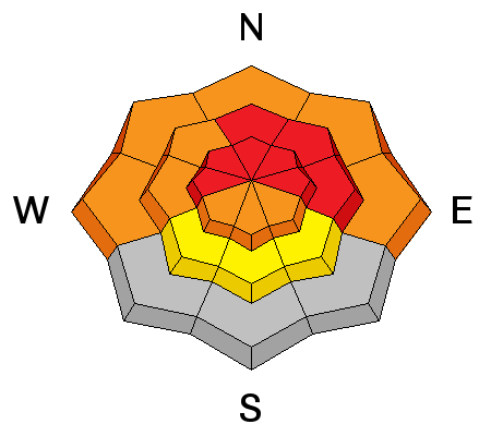
I'm not sure if the over 2" of water weight in the heavy new snow from yesterday and overnight is enough to reactivate the widespread very weak faceted layers and depth hoar that plague all elevations in the Logan Zone, but it could be more than enough in some areas. In these areas, very dangerous triggered persistent slab and/or deep slab avalanches failing on buried weak layers are likely on steep slopes with significant fresh accumulations of drifted heavy snow. Natural persistent slab avalanches are possible in steep terrain. In these conditions, you could trigger avalanches remotely, from a distance or from the flats below steep slopes.
|
| type | aspect/elevation | characteristics |
|---|

|
|
LIKELIHOOD
LIKELY
UNLIKELY
SIZE
 LARGE
SMALL
TREND
 INCREASING DANGER
SAME
DECREASING DANGER
|
|
description
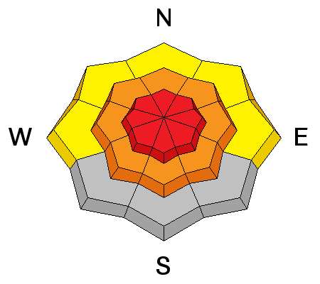
Heavy storm snow may not bond very well to existing surface hoar or weak small-grained faceted snow that formed on the snow surface during the two weeks of high pressure. Fresh wind slabs failing on the old snow surface are likely in terrain exposed to drifting, especially on upper elevation lee slopes. But watch for and avoid fresh wind deposited snow in and around terrain features like gullies, scoops, sub-ridges, and rock bands or cliffs at all elevations and on slopes facing all directions.. |
| type | aspect/elevation | characteristics |
|---|

|
|
LIKELIHOOD
LIKELY
UNLIKELY
SIZE
LARGE
SMALL
TREND
 INCREASING DANGER
SAME
DECREASING DANGER
|
|
description
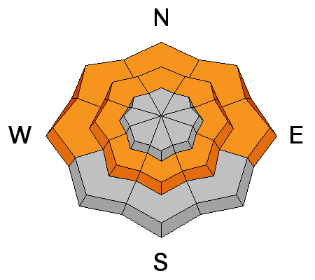
Rain yesterday on the weak existing snow created dangerous wet avalanche conditions at lower and mid elevations. Natural wet avalanches are possible and triggered avalanches likely today in steep terrain with saturated weak snow. |
 |
weather The National Weather Service has continued a Winter Storm Warning through Friday morning. Expect snow today, with an additional 2 to 4 inches of accumulation, moderate west wind, and 8500' high temperatures around 26 degrees. Low overnight temperatures are expected to be around 17 degrees with winds shifting around from the east northeast and decreasing somewhat. Unsettled weather will continue through tomorrow, but not much in the way of additional accumulation is expected until Saturday, when 3 to 5 inches is forecast. Check out our one-stop weather page........HERE |
| general announcements For a safer powder option; Discount lift tickets are available at Backcountry.com - Thanks to Ski Utah and the Utah Resorts, including Beaver Mountain. All proceeds go towards paying for Utah Avalanche Center avalanche and mountain weather advisories. Utah Avalanche Center mobile app - Get your advisory on your iPhone along with great navigation and rescue tools. Remember your information can save lives. If you see anything we should know about, please participate in the creation of our own community avalanche advisory by submitting snow and avalanche conditions. You can also call us at 801-524-5304 or 800-662-4140, email by clicking HERE, or include #utavy in your tweet or Instagram. Follow us at UAClogan on Twitter I'll issue these advisories on Monday, Wednesday, Friday, and Saturday mornings. This advisory is produced by the U.S.D.A. Forest Service, which is solely responsible for its content. It describes only general avalanche conditions and local variations always exist. |


_1.jpg)
