
| During the month of April, Mark Miller will donate $75 to the charity of your choice (5 to chose from, including the Utah Avalanche Center!) Mark Miller Subaru has raised over $300k in the previous 6 Do Good Feel Good events. More Info here |  |
| During the month of April, Mark Miller will donate $75 to the charity of your choice (5 to chose from, including the Utah Avalanche Center!) Mark Miller Subaru has raised over $300k in the previous 6 Do Good Feel Good events. More Info here | |
| Advisory: Logan Area Mountains | Issued by Toby Weed for Wednesday - January 29, 2014 - 7:07am |
|---|

|
bottom line Expect a rising danger and a Level 2 or MODERATE danger in the backcountry today. Warming temperatures, rain up to around 8000', heavy snowfall, and sustained winds will cause the danger to rise significantly in the next couple days. Heightened persistent slab avalanche conditions already exist on some steep slopes, and heightened wind slab and wet avalanche conditions could develop today on others. You could trigger dangerous persistent slab avalanches on slopes with poor snow structure, and thinner areas of an existing slab are potential trigger points. Evaluate the snow and terrain carefully, and avoid steep drifted slopes and slopes with rain saturated or moist surface snow
|
 |
avalanche watch THIS AVALANCHE WATCH IS FOR ALL THE MOUNTAINS OF NORTHERN AND CENTRAL UTAH, TO INCLUDE THE WESTERN UINTA MOUNTAINS...AND AS FAR SOUTH AS THE FISHLAKE PLATEAU AND ALONG THE I-70 CORRIDOR. EXPECTED HEAVY SNOWFALL AND STRONG WINDS WILL CREATE DANGEROUS AVALANCHE CONDITIONS THROUGH THE REST OF THE WEEK AND INTO THE WEEKEND. THIS WATCH DOES NOT INCLUDE SKI AREAS OR HIGHWAYS WHERE AVALANCHE CONTROL IS NORMALLY DONE. |
 |
current conditions The Tony Grove Snotel at 8400' reports an inch of snow in the last 24 hours. It's 25 degrees and there's 45 inches of total snow containing 70% of average water content for the date. It's 20 degrees at the 9700' Logan Peak weather station, and winds increased overnight. I'm currently reading southwest winds averaging about 25 mph. It's been over two weeks now since our last storm and the danger is mostly LOW this morning, but weak faceted snow and very poor snow structure plague all elevations of the Logan Zone, and rising temperatures, rain, heavy snowfall, and sustained winds, will cause the avalanche danger to rise significantly in the next couple days.
Northwest radar view from NWS, showing what's currently upstream and coming our way. (0600) |
 |
recent activity The Logan area experienced widespread natural avalanches and a couple accidents with our last storm, over two weeks ago now. The most recent triggered avalanche occurred on 1-17-2014, just north of the Idaho state line, above Bloomington Lake. For a list of this and other avalanche activity and observations visit our updated Observations Page
Many large natural avalanches on upper elevation slopes in the Logan Area Mountains from around two weeks ago are still quite visible, like these off the north Shoulder of Naomi Peak in Bullen Basin. (1-24-2014 )
|
| type | aspect/elevation | characteristics |
|---|

|
|
LIKELIHOOD
 LIKELY
UNLIKELY
SIZE
 LARGE
SMALL
TREND
 INCREASING DANGER
SAME
DECREASING DANGER
|
|
description
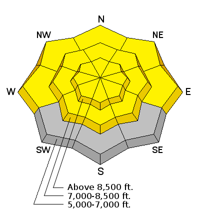
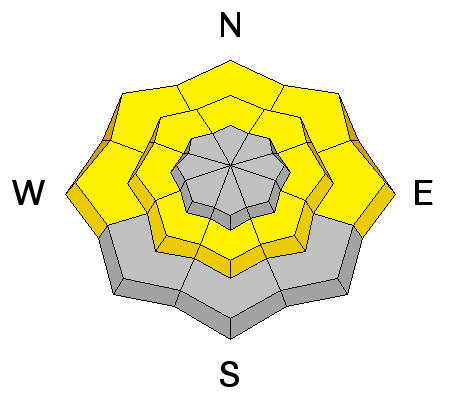
The very weak faceted snow plaguing the basal layers, and in many cases the entire snowpack is currently dormant, and triggered persistent slab avalanches are fairly unlikely. Problem is, you might still be able to trigger a slab from a thinner spot, and if you do trigger one, it could be large, destructive, and potentially deadly. Poor snow structure is widespread across the Logan Zone, and although fairly unlikely, avalanches are still possible in many areas, with very steep, rocky, north, northeast, and east facing slopes above around 8000' in elevation the most suspect. The widespread diabolical facets are apparently dormant now but could soon be reactivated. Warming temperatures, rain at lower elevations, heavy snowfall, and drifting from sustained winds will certainly cause the avalanche danger to rise significantly in the next couple days and the increase in danger could be rapid. |
| type | aspect/elevation | characteristics |
|---|

|
|
LIKELIHOOD
LIKELY
UNLIKELY
SIZE
 LARGE
SMALL
TREND
INCREASING DANGER
SAME
DECREASING DANGER
|
|
description
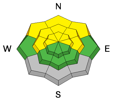
With accumulation today, fresh drifts and soft wind slabs could become sensitive in exposed terrain especially on lee slopes. A smaller wind slab overrunning a slope with poor snow structure or very weak snow could create a larger more dangerous avalanche. Watch for and avoid fresh wind deposited snow in and around terrain features like gullies, scoops, sub-ridges, and rock bands or cliffs. |
| type | aspect/elevation | characteristics |
|---|

|
|
LIKELIHOOD
 LIKELY
UNLIKELY
SIZE
LARGE
SMALL
TREND
INCREASING DANGER
SAME
DECREASING DANGER
|
|
description
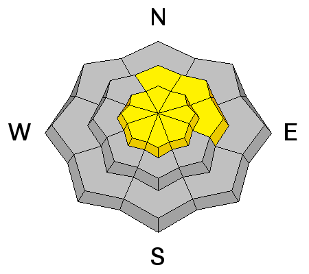
The rain/snow line will be rising today, up to around 8000'. Rain on the weak existing snow could create heightened wet avalanche conditions at lower and mid elevations, with triggered avalanches becoming possible in steep terrain with enough moisture. |
 |
weather The National Weather Service has issued a Winter Storm Warning through Friday morning. Heavy snowfall and strong winds are expected. It will snow today up high but the rain/snow line will rise in elevation, perhaps up to around 8000'. Expect increasing southwest wind and 3 to 5 inches of accumulation possible by evening. The storm will intensify overnight tonight with stronger southwest winds becoming west and snow. Snow will continue through the day tomorrow, with west northwest winds and 8 to 16 inches of additional accumulation by tomorrow evening.... Check out our one-stop weather page........HERE |
| general announcements For a safer powder option; Discount lift tickets are available at Backcountry.com - Thanks to Ski Utah and the Utah Resorts, including Beaver Mountain. All proceeds go towards paying for Utah Avalanche Center avalanche and mountain weather advisories. Utah Avalanche Center mobile app - Get your advisory on your iPhone along with great navigation and rescue tools. Remember your information can save lives. If you see anything we should know about, please participate in the creation of our own community avalanche advisory by submitting snow and avalanche conditions. You can also call us at 801-524-5304 or 800-662-4140, email by clicking HERE, or include #utavy in your tweet or Instagram. Follow us at UAClogan on Twitter I'll issue these advisories on Monday, Wednesday, Friday, and Saturday mornings. This advisory is produced by the U.S.D.A. Forest Service, which is solely responsible for its content. It describes only general avalanche conditions and local variations always exist. |


_1.jpg)


