| During the month of April, Mark Miller will donate $75 to the charity of your choice (5 to chose from, including the Utah Avalanche Center!) Mark Miller Subaru has raised over $300k in the previous 6 Do Good Feel Good events. More Info here |  |
| During the month of April, Mark Miller will donate $75 to the charity of your choice (5 to chose from, including the Utah Avalanche Center!) Mark Miller Subaru has raised over $300k in the previous 6 Do Good Feel Good events. More Info here | |
| Advisory: Logan Area Mountains | Issued by Toby Weed for Monday - January 27, 2014 - 7:03am |
|---|

|
bottom line While the danger is LOW on most slopes in the Logan area, heightened avalanche conditions remain in places, and there's still a Level 2 or MODERATE danger in the backcountry. You could trigger dangerous persistent slab avalanches on slopes with poor snow structure, where a thicker or more cohesive slab sits on top of very weak sugary or faceted snow. The danger is greatest in extreme terrain and on very steep drifted upper elevation north, northeast, and east facing slopes that have not already avalanched. Shallower areas on an existing slab are potential trigger points. Fresher wind slab avalanches are possible on slopes with recent wind deposits. Evaluate the snow and terrain carefully, and continue to avoid very steep, and especially drifted slopes.
|
 |
current conditions The Tony Grove Snotel at 8400' reports 26 degrees and 46 inches of total snow containing 72% of average water content for the date. It's 17 degrees at the 9700' Logan Peak weather station, and winds increased overnight. I'm reading west winds averaging in the mid-twenties this morning. It's been two weeks now since our last storm and a widespread natural avalanche cycle, and the danger is mostly LOW, with large avalanches ever less likely. But, weak faceted snow and very poor snow structure plague the Logan Zone and heightened avalanche conditions remain on steep slopes in the backcountry, mainly at upper elevations.
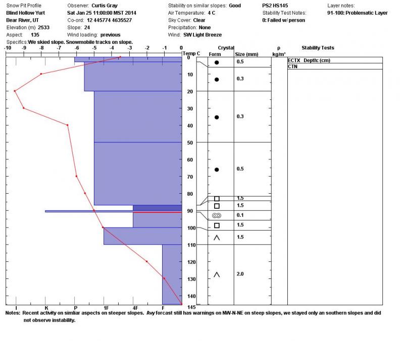
This snow profile from Blind Hollow shows the poor snow structure that is widespread in the region. 1-25-2014 (Gray) |
 |
recent activity The Logan area experienced widespread natural avalanches and a couple accidents with our last storm, over two weeks ago now. The most recent triggered avalanche occurred on 1-17-2014, just north of the Idaho state line, above Bloomington Lake. For a list of this and other avalanche activity and observations visit our updated Observations Page
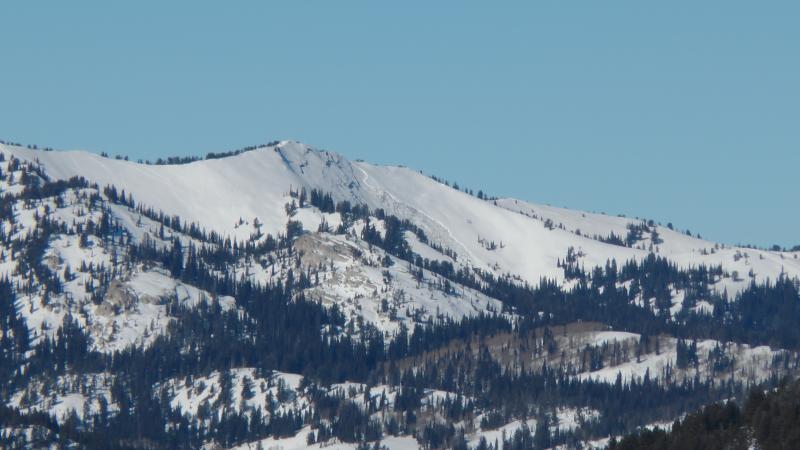
Many large natural avalanches on upper elevation slopes in the Logan Area Mountains from around two weeks ago are still quite visible, like this one north of the Idaho state line on Wilderness Peak in Franklin Basin. (1-25-2014, Carlisle)
|
| type | aspect/elevation | characteristics |
|---|

|

|
LIKELIHOOD
 LIKELY
UNLIKELY
SIZE
 LARGE
SMALL
TREND
 INCREASING DANGER
SAME
DECREASING DANGER
|
|
description
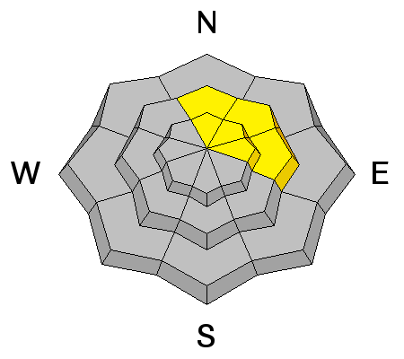
Despite widespread poor snow structure, general snow stability is gradually increasing with time, and it is growing ever more unlikely that you could trigger a dangerous persistent slab avalanche. Problem is, if you do trigger one, it could be large, destructive, and potentially deadly. Poor snow structure is widespread and although not very likely, avalanches are possible in many areas. Very steep, rocky, north, northeast, and east facing slopes above around 8000' in elevation are the most suspect, but watch terrain features where old slabs sit on very weak faceted snow. |
| type | aspect/elevation | characteristics |
|---|

|
|
LIKELIHOOD
LIKELY
UNLIKELY
SIZE
 LARGE
SMALL
TREND
 INCREASING DANGER
SAME
DECREASING DANGER
|
|
description
Fresher wind slabs could be sensitive to human weight in exposed lee slope terrain. A smaller wind slab overrunning a slope with poor snow structure or very weak snow could create a larger more dangerous avalanche. Watch for and avoid fresh wind deposits in and around terrain features like gullies, scoops, sub-ridges, and rock bands or cliffs. |
 |
weather A weather disturbance dropping out of Western Canada will graze our region today, and some light snowfall is possible and colder air likely in the mountains of northern Utah. It'll be partly sunny again today, with 8500' high temperatures around 28 degrees, a twenty percent chance of snow showers, and a moderate west-northwest wind. Hopefully, the front will contain enough cold air to turn over the inversions and let some fresh air into the valleys. A change in the weather pattern is on the way, with a series of weather disturbances and mountain snowfall scheduled to impact our area between Tuesday night and Friday... Yippee! Check out our one-stop weather page........HERE |
| general announcements For a safer powder option; Discount lift tickets are available at Backcountry.com - Thanks to Ski Utah and the Utah Resorts, including Beaver Mountain. All proceeds go towards paying for Utah Avalanche Center avalanche and mountain weather advisories. Utah Avalanche Center mobile app - Get your advisory on your iPhone along with great navigation and rescue tools. Remember your information can save lives. If you see anything we should know about, please participate in the creation of our own community avalanche advisory by submitting snow and avalanche conditions. You can also call us at 801-524-5304 or 800-662-4140, email by clicking HERE, or include #utavy in your tweet or Instagram. Follow us at UAClogan on Twitter I'll issue these advisories on Monday, Wednesday, Friday, and Saturday mornings. This advisory is produced by the U.S.D.A. Forest Service, which is solely responsible for its content. It describes only general avalanche conditions and local variations always exist. |


_1.jpg)