| During the month of April, Mark Miller will donate $75 to the charity of your choice (5 to chose from, including the Utah Avalanche Center!) Mark Miller Subaru has raised over $300k in the previous 6 Do Good Feel Good events. More Info here |  |
| During the month of April, Mark Miller will donate $75 to the charity of your choice (5 to chose from, including the Utah Avalanche Center!) Mark Miller Subaru has raised over $300k in the previous 6 Do Good Feel Good events. More Info here | |
| Advisory: Logan Area Mountains | Issued by Toby Weed for Saturday - January 18, 2014 - 6:48am |
|---|

|
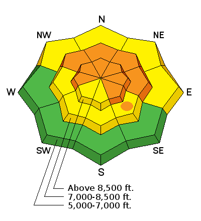
bottom line There is a Level 3 or CONSIDERABLE danger in the backcountry, and very dangerous triggered deep slab avalanches are likely on steep drifted slopes with poor snow structure that have not already avalanched. Upper elevation northeast, east, and southeast facing slopes appear to be the most dangerous, and you could trigger dangerous avalanches remotely, meaning from a distance or below. Triggered wet avalanches will become more likely on steep sunny slopes with midday warming. Careful snowpack evaluation, cautious route-finding, and conservative decision making will be essential for safe travel in the backcountry through the weekend. Continue to avoid steep drifted slopes that have not yet avalanched.
|
 |
special announcement The Utah Avalanche Center in Logan is offering two upcoming avalanche awareness classes. On January 23 and 25, we are offering an advanced awareness class for those wanting to refresh their skills or learn more about traveling safely in avalanche terrain. And on February 15, the center is teaming up with the ZBROS to offer a combined riding skills and essential avalanche skills field day for snowmobilers. Come join us to learn more about how to stay safe in the backcountry. More information and registration is available on our website or by calling 435-757-2794. Visit our list of upcoming classes..........HERE |
 |
current conditions The Tony Grove Snotel at 8400' reports 26 degrees and 50 inches of total snow containing 82% of average water content for the date. It's 27 degrees at the 9700' Logan Peak weather station, and I'm reding northwest winds averaging in the teens overnight. Dangerous avalanche conditions remain in the backcountry, especially at upper elevations and on easterly facing slopes. You can find pretty good and safer settled powder conditions in sheltered lower angled terrain, but sunny slopes are a bit crusty and lots of upper elevation slopes are either wind-jacked or have recently avalanched to the ground during an active natural avalanche cycle over the weekend and on Monday.
That's me on the bed surface of the Fairgrounds Avalanche on the east side of Logan Peak. There's not much snow left on most of the big hills in upper Providence Canyon The UAC's video of our 1-14-2014 visit to the Fairgrounds Avalanche is fast approaching 5000 viewings on YouTube. Watch it .....HERE***
|
 |
recent activity It will be a good weekend for avalanche viewing in the Bear River backcountry, with a long list of natural and a few triggered avalanches that occurred late in the recent windy storm, so are still quite visible.. Large avalanche debris fields can be considered safe zones, especially if the entire slope above you already avalanched to the ground, but I'm not going anywhere near, or especially under any steep north or east facing slopes that didn't yet avalanche. Thanks for sending in your observations, it's of huge benefit to us to hear from you, and I am interested in what you see, or don't see out there in the next few days...
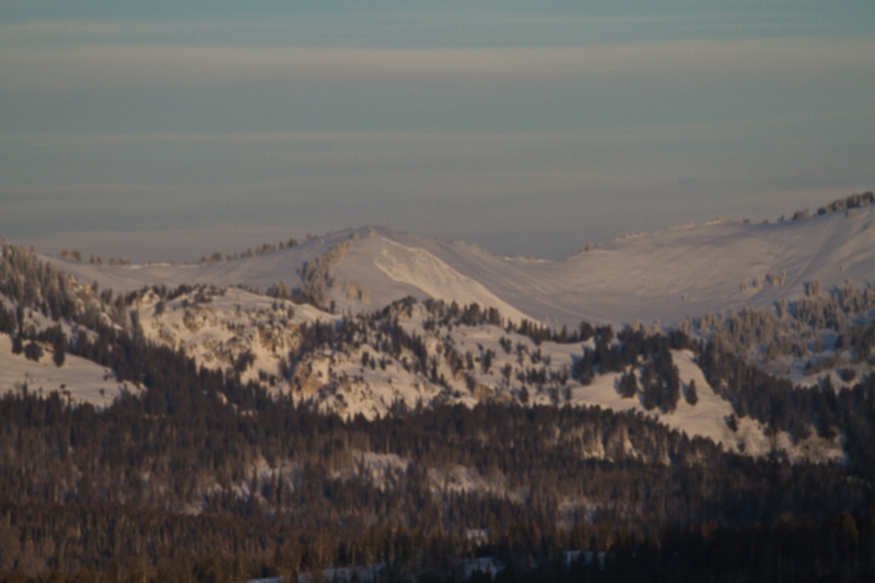
This large ESE facing slope in White Canyon north of the Idaho State Line naturally avalanched sometime Monday. (Seeholzer)
|
| type | aspect/elevation | characteristics |
|---|

|
|
LIKELIHOOD
 LIKELY
UNLIKELY
SIZE
 LARGE
SMALL
TREND
 INCREASING DANGER
SAME
DECREASING DANGER
|
|
description
The danger of very dangerous deep slab avalanches is gradually decreasing, but you are still likely to trigger potentially huge and destructive avalanches, especially on steep easterly facing slopes at upper elevations that haven't yet avalanched. A stout slab developed with the windy and moist storm over the weekend on widespread very weak faceted snow caused by very shallow coverage and cold dry conditions in December. The exceptionally deep faceted snow is capped in many areas by a rime or rain crust from just before Christmas, which may be part of the reason we now see such well connected deep slab avalanches. Audible collapsing and shooting cracks are relevant red flags, but you should plan to continue to avoid and stay out from under steep drifted slopes. |
| type | aspect/elevation | characteristics |
|---|

|

|
LIKELIHOOD
LIKELY
UNLIKELY
SIZE
 LARGE
SMALL
TREND
 INCREASING DANGER
SAME
DECREASING DANGER
|
|
description
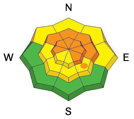
Wet avalanches are possible on steep sunny slopes with moist surface snow, especially during midday heating. |
 |
weather It will be warm and sunny in the mountains today, with moderate west northwest wind, and 8500' high temperatures around 40 degrees. Expect fair and sunny weather in the mountains again tomorrow and for the next few days. There's a chance of a bit of snow around Thursday, but don't get your hopes up yet. Check out our one-stop weather page........HERE |
| general announcements For a safer powder option; Discount lift tickets are available at Backcountry.com - Thanks to Ski Utah and the Utah Resorts, including Beaver Mountain. All proceeds go towards paying for Utah Avalanche Center avalanche and mountain weather advisories. Utah Avalanche Center mobile app - Get your advisory on your iPhone along with great navigation and rescue tools. Remember your information can save lives. If you see anything we should know about, please participate in the creation of our own community avalanche advisory by submitting snow and avalanche conditions. You can also call us at 801-524-5304 or 800-662-4140, email by clicking HERE, or include #utavy in your tweet or Instagram. Follow us at UAClogan on Twitter I'll issue these advisories on Monday, Wednesday, Friday, and Saturday mornings. This advisory is produced by the U.S.D.A. Forest Service, which is solely responsible for its content. It describes only general avalanche conditions and local variations always exist. |


_1.jpg)