| During the month of April, Mark Miller will donate $75 to the charity of your choice (5 to chose from, including the Utah Avalanche Center!) Mark Miller Subaru has raised over $300k in the previous 6 Do Good Feel Good events. More Info here |  |
| During the month of April, Mark Miller will donate $75 to the charity of your choice (5 to chose from, including the Utah Avalanche Center!) Mark Miller Subaru has raised over $300k in the previous 6 Do Good Feel Good events. More Info here | |
| Advisory: Logan Area Mountains | Issued by Toby Weed for Monday - January 13, 2014 - 6:43am |
|---|


|
bottom line There is a HIGH or Level 4 danger, and large and destructive avalanches are likely on drifted slopes in the backcountry. Triggered wind slab and very dangerous deep slab avalanches are likely on steep drifted slopes, and large natural avalanches are still possible today. Avoid travel in avalanche terrain today, and continue to stay off of and out from under steep slopes and obvious or historic avalanche paths.
|
 |
avalanche warning THIS AVALANCHE WARNING IS FOR THE MOUNTAINS OF NORTHERN AND CENTRAL UTAH, TO INCLUDE THE WESTERN UINTA MOUNTAINS. VERY DANGEROUS AVALANCHE CONDITIONS EXIST THROUGH TODAY...AVOID BEING ON OR BENEATH STEEP MOUNTAIN SLOPES...AS AVALANCHES MAY BE TRIGGERED LOW ON THE SLOPE AS WELL.
|
 |
special announcement For a safer powder option; Discount lift tickets are available at Backcountry.com - Thanks to Ski Utah and the Utah Resorts, including Beaver Mountain. All proceeds go towards paying for Utah Avalanche Center avalanche and mountain weather advisories.
|
 |
current conditions The Tony Grove Snotel at 8400' reports well over a foot of new snow containing 1.6" of water in the last 24 hours. The station picked up 4.5" of water in the last 5 days, since January 8. It's currently 22 degrees and there is 59 inches of total snow on the ground, containing 89% of average water content for the date. It's 16 degrees at the 9700' Logan Peak weather station and the wind sensor appears to be rimed or covered by ice. West winds have diminished somewhat overnight at the Hwy 89 Logan Summit weather station, after posting average wind speeds close to 40 mph yesterday with gusts in the upper 50s. Very dangerous avalanche conditions exist in the backcountry, with drifted and inverted heavy new snow, difficult trail-breaking, and safe riding limited to lower angled meadows and packed trails. The heavy new snow from the past several days accumulated and was drifted onto slopes with widespread very weak preexisting sugary or faceted snow....
A quick look at the 7-day snow data from the Tony Grove Snotel. 1-13-2014
|
 |
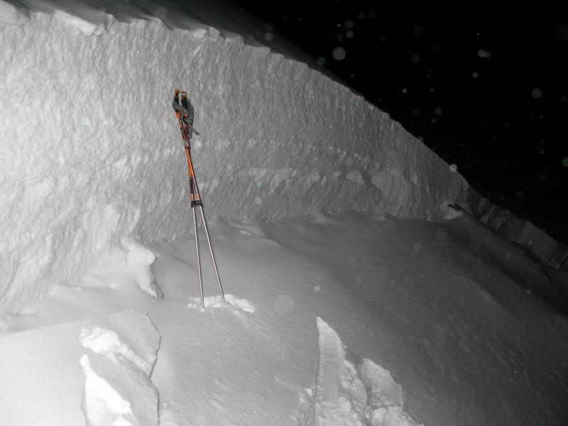
recent activity A Utah rider triggered and was caught, carried and fully buried by a very large hard slab avalanche north of the Idaho State Line. The 3 to 5 foot deep and perhaps 500' wide avalanche failed on weak snow near the ground. The severely injured rider had to be rope hauled back up the steep slope in a heroic late night rescue effort by Cache, Franklin, and Bear Lake County SAR. The east face of Logan Peak apparently also avalanched wall to wall and to the ground in the afternoon of 1-11-2014, and we're still unsure of the trigger. Observers noticed a couple natural persistent slab avalanches, which occurred in the afternoon yesterday 1-12-2014 at lower elevations in Logan Canyon...
|
| type | aspect/elevation | characteristics |
|---|

|

|
LIKELIHOOD
 LIKELY
UNLIKELY
SIZE
 LARGE
SMALL
TREND
 INCREASING DANGER
SAME
DECREASING DANGER
|
|
description
Very dangerous human triggered avalanches failing in old weak faceted snow or in the basal layers of the existing snow pack are still likely on steep drifted slopes today. You could trigger large and destructive avalanches remotely, from a distance, or worse, from below. Heavy snowfall and sustained strong west winds built significant cohesive and heavy slab on very weak sugary or faceted snow. This unstable snow structure is now widespread across the Logan Zone at all elevations.
|
| type | aspect/elevation | characteristics |
|---|

|
|
LIKELIHOOD
 LIKELY
UNLIKELY
SIZE
 LARGE
SMALL
TREND
 INCREASING DANGER
SAME
DECREASING DANGER
|
|
description
Here are are few reasons why you should avoid travel in avalanche terrain today:
2. Observed audible collapsing or whoompfing. (observers report extensive collapsing in the Garden City Canyon Area Sunday) 3. Shooting cracks observed, some quite deep and long. (see my video observation from 1-10-2014..... HERE) 4. Serious and significant drifting with sustained and strong west winds for the last 4 days. 5. Heavy snow and rapid overnight accumulations. 4.5" of water equivalent at Tony Grove since 1-8-2014 Wind slab, storm snow, persistent slab, and deep slab avalanches are all likely in the backcountry today. Natural persistent slab activity reported at lower elevations yesterday.
A natural avalanche at 6800' on a west facing slope hit Hwy 89 in Beaver Canyon yesterday afternoon. 1-12-2014 (Pagnucco)
|
 |
weather Snow showers will probably continue for a while this morning, with another 1 to 3 inches of accumulation forecast and continuing fairly strong northwest winds. High temperatures at 8500' are expected to be around 28 degrees today, dropping to into the mid teens overnight. The stormy weather will move off to the east today and a strong high pressure system will gradually build over the region. Expect fair and sunny weather in the mountains tomorrow and for most of the coming work week. Check out our one stop weather page........HERE |
| general announcements For a safer powder option; Discount lift tickets are available at Backcountry.com - Thanks to Ski Utah and the Utah Resorts, including Beaver Mountain. All proceeds go towards paying for Utah Avalanche Center avalanche and mountain weather advisories. Utah Avalanche Center mobile app - Get your advisory on your iPhone along with great navigation and rescue tools. -The Utah Avalanche Center along with the Montana State University Ski Tracks project combines GPS technology with detailed logbook surveys completed by participants to help us understand how and why decisions are made in the winter backcountry. Participants will use a free smartphone app to record and send us their ski routes then, they will complete a simple online survey telling us some of the features of their tour. For more information visit: www.montana.edu/snowscience/tracks Benefit the Utah Avalanche Center when you shop from Backcountry.com or REI: Click this link for Backcountry.com or this link to REI, shop, and they will donate a percent of your purchase price to the UAC. Both offer free shipping (with some conditions) so this costs you nothing! Benefit the Utah Avalanche Center when you buy or sell on ebay - set the Utah Avalanche Center as a favorite non-profit in your ebay account here and click on ebay gives when you buy or sell. You can choose to have your seller fees donated to the UAC, which doesn't cost you a penny. Remember your information can save lives. If you see anything we should know about, please participate in the creation of our own community avalanche advisory by submitting snow and avalanche conditions. You can also call us at 801-524-5304 or 800-662-4140, email by clicking HERE, or include #utavy in your tweet or Instagram. Follow us at UAClogan on Twitter I'll issue these advisories on Monday, Wednesday, Friday, and Saturday mornings. This advisory is produced by the U.S.D.A. Forest Service, which is solely responsible for its content. It describes only general avalanche conditions and local variations always exist. |


_1.jpg)