| During the month of April, Mark Miller will donate $75 to the charity of your choice (5 to chose from, including the Utah Avalanche Center!) Mark Miller Subaru has raised over $300k in the previous 6 Do Good Feel Good events. More Info here |  |
| During the month of April, Mark Miller will donate $75 to the charity of your choice (5 to chose from, including the Utah Avalanche Center!) Mark Miller Subaru has raised over $300k in the previous 6 Do Good Feel Good events. More Info here | |
| Advisory: Logan Area Mountains | Issued by Toby Weed for Saturday - January 11, 2014 - 6:34am |
|---|

|
bottom line There is a HIGH or Level 4 danger, and avalanches are likely on drifted upper and mid elevation slopes in the backcountry. Dangerous avalanche conditions are developing or exist in some areas at lower elevations as well. Dangerous triggered wind slab and persistent slab avalanches are likely on steep drifted slopes, and natural avalanches are quite possible. Large natural avalanches will become likely overnight, with another bout of strong winds and heavy snow forecast. Avoid travel in avalanche terrain today, stay off of and out from under steep slopes and obvious or historic avalanche paths.
|
 |
avalanche warning THIS AVALANCHE WARNING IS FOR THE MOUNTAINS OF NORTHERN AND CENTRAL UTAH, TO INCLUDE THE WESTERN UINTA MOUNTAINS. VERY DANGEROUS AVALANCHE CONDITIONS EXIST THROUGH THE WEEKEND...AVOID BEING ON OR BENEATH STEEP MOUNTAIN SLOPES...AS AVALANCHES MAY BE TRIGGERED LOW ON THE SLOPE AS WELL. THIS WARNING DOES NOT INCLUDE SKI AREAS OR HIGHWAYS WHERE AVALANCHE CONTROL IS NORMALLY DONE. |
 |
special announcement For a safer powder option; Discount lift tickets are available at Backcountry.com - Thanks to Ski Utah and the Utah Resorts, including Beaver Mountain. All proceeds go towards paying for Utah Avalanche Center avalanche and mountain weather advisories.
|
 |
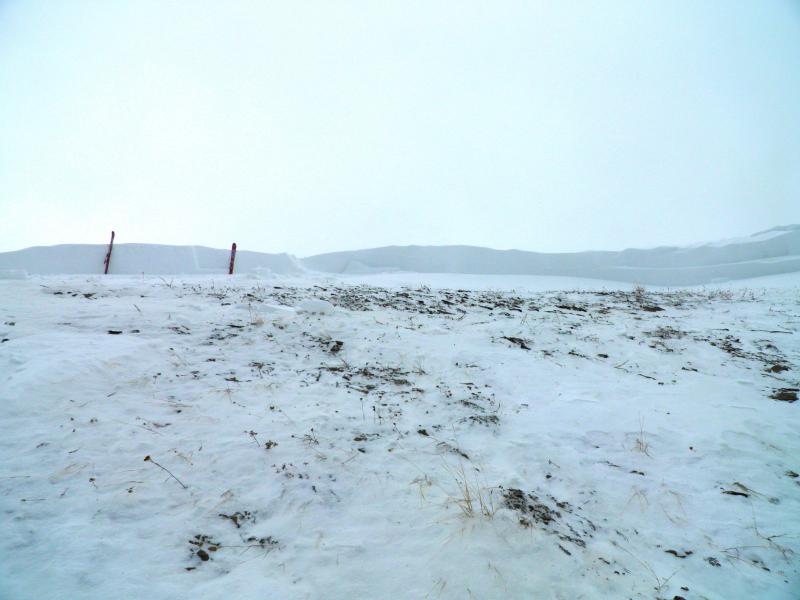
current conditions The Tony Grove Snotel at 8400' reports close to two feet of new snow in the last 48 hours, containing 1.9 inches of water. It's a balmy 28 degrees this morning, and there is 49 inches of total snow containing 77% of average water content for the date. I am reading more reasonable west winds this morning at the UDOT Hwy 89 Logan Summit wind sensor, after sustained high winds for several hours yesterday, with 40+ mph average west winds and gusts close to 60 mph. The 9700' Logan Peak weather station reports 23 degrees, and southwest winds in the upper teens. Very dangerous avalanche conditions exist in the backcountry, with drifted and inverted heavy new snow, difficult trailbreaking, and safe riding limitted to lower angled meadows and packed trails. The heavy new snow is being drifted onto slopes with widespread very weak preexisting sugary or faceted snow.
|
 |
recent activity There were several large natural and triggered avalanches across the Utah backcountry yesterday, with avalanches stepping down into weak basal layers. See our updated backcountry observations ......HERE.
The crown of a large natural avalanche on the Wasatch Crest near Park City, 1-10-2014 (White) Locally; i cracked out a few wind slabs and collapsed a couple sizable cornices on drifted test slopes in the backcountry near Beaver Mt. yesterday. Have a look at my video observation on YouTube...........HERE |
| type | aspect/elevation | characteristics |
|---|

|
|
LIKELIHOOD
 LIKELY
UNLIKELY
SIZE
 LARGE
SMALL
TREND
 INCREASING DANGER
SAME
DECREASING DANGER
|
|
description
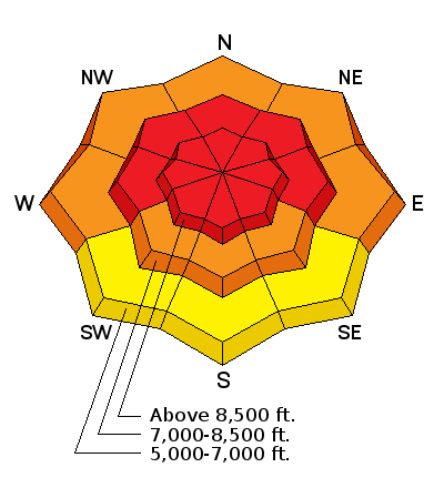
Very dangerous wind slab avalanche conditions exist in exposed upper and mid elevation terrain, and the danger will increase and become more widespread overnight as more snow accumulates and is drifted by sustained strong west winds. Triggered wind slab avalanches and large cornice falls are likely on steep slopes with recent deposits of drifted snow, which are widespread across the region. Wind slabs generally form on the lee side of exposed ridge lines, but can also form on any slope aspect, especially in and around terrain features like gullies, scoops, sub-ridges, rock outcroppings, and cliff bands. Avoid steep slopes with recent wind deposits, which are often smooth, rounded and chalky looking, and can sound hollow or drum-like. It is possible that a wind slab avalanche could step down into weak old snow, producing a larger more dangerous avalanche.
|
| type | aspect/elevation | characteristics |
|---|

|
|
LIKELIHOOD
 LIKELY
UNLIKELY
SIZE
 LARGE
SMALL
TREND
INCREASING DANGER
SAME
DECREASING DANGER
|
|
description
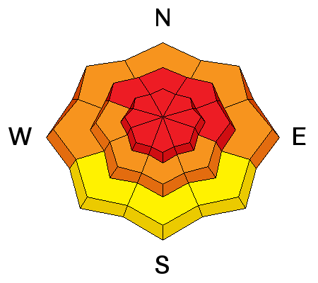
Dangerous human triggered avalanches failing in old weak faceted snow or in the basal layers of the existing snow pack are likely on slopes with poor snow structure, especially in drifted upper and mid-elevation terrain. I've found very weak preexisting faceted snow to be widespread in the Logan Zone, and it plagues slopes at all elevations, so we'll find a danger of persistent slab avalanches pretty much anywhere a significant slab layer consisting of more cohesive snow develops. Warmer temperatures, possible rain and continued drifting may lead to increasing danger today, and as cohesive slab layer forms, it is becoming more likely that you could trigger avalanches remotely, from a distance, or worse, from below. Audible collapsing or whoompfing is a significant red flag indicating serious persistent slab avalanche potential. Recent drifting and rapid accumulations, cracking, and perhaps natural avalanches are other red flags to take heed of today. An energetic storm overnight and tomorrow will cause the danger of persistent slabs to rise further still and become even more widespread.
|
 |
weather We'll see a bit of a break in the stormy weather in the mountains today, but west winds will continue and strengthen ahead of the next energetic wave of storminess, which will begin to affect our area this afternoon. Expect 8500' high temperatures around 35 degrees, and a period of pre-frontal rain is likely below around 7500 this afternoon. Snowfall will increase tonight and continue tomorrow, with westerly winds remaining in the strong category. 6 to 14 inches of accumulation is forecast by tomorrow evening. A high pressure system will gradually build over our region as we head into the work week. Check out our one stop weather page........HERE |
| general announcements Utah Avalanche Center mobile app - Get your advisory on your iPhone along with great navigation and rescue tools. -The Utah Avalanche Center along with the Montana State University Ski Tracks project combines GPS technology with detailed logbook surveys completed by participants to help us understand how and why decisions are made in the winter backcountry. Participants will use a free smartphone app to record and send us their ski routes then, they will complete a simple online survey telling us some of the features of their tour. For more information visit: www.montana.edu/snowscience/tracks Benefit the Utah Avalanche Center when you shop from Backcountry.com or REI: Click this link for Backcountry.com or this link to REI, shop, and they will donate a percent of your purchase price to the UAC. Both offer free shipping (with some conditions) so this costs you nothing! Benefit the Utah Avalanche Center when you buy or sell on ebay - set the Utah Avalanche Center as a favorite non-profit in your ebay account here and click on ebay gives when you buy or sell. You can choose to have your seller fees donated to the UAC, which doesn't cost you a penny. Remember your information can save lives. If you see anything we should know about, please participate in the creation of our own community avalanche advisory by submitting snow and avalanche conditions. You can also call us at 801-524-5304 or 800-662-4140, email by clicking HERE, or include #utavy in your tweet or Instagram. Follow us at UAClogan on Twitter I'll issue these advisories on Monday, Wednesday, Friday, and Saturday mornings. This advisory is produced by the U.S.D.A. Forest Service, which is solely responsible for its content. It describes only general avalanche conditions and local variations always exist. |


_1.jpg)