| During the month of April, Mark Miller will donate $75 to the charity of your choice (5 to chose from, including the Utah Avalanche Center!) Mark Miller Subaru has raised over $300k in the previous 6 Do Good Feel Good events. More Info here |  |
| During the month of April, Mark Miller will donate $75 to the charity of your choice (5 to chose from, including the Utah Avalanche Center!) Mark Miller Subaru has raised over $300k in the previous 6 Do Good Feel Good events. More Info here | |
| Advisory: Logan Area Mountains | Issued by Toby Weed for Thursday - January 9, 2014 - 6:48am |
|---|


|
bottom line Heightened avalanche conditions already exist this morning in the Logan Area backcountry, and heavy snowfall and intensifying westerly winds will create a rising avalanche danger throughout the day. Dangerous avalanche conditions will develop and become more widespread, and the danger level will rise to Level 3 or CONSIDERABLE in many areas. Triggered wind slab, storm snow, and persistent slab avalanches will become probable, and some natural avalanches are possible by this afternoon, especially at upper elevations. Careful snowpack evaluation, cautious route-finding, and conservative decision making will be essential for safe travel in the backcountry.
|
 |
special announcement Dangerous avalanche conditions are developing in the mountains and it looks like it'll be pretty scary in the backcountry this weekend. --Sign up now for our Avalanche 101 course, which starts this evening in Logan, and will go into the field on Saturday................. Information and registration
|
 |
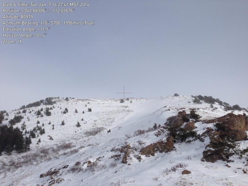
current conditions The Tony Grove Snotel at 8400' reports three or four inches of new snow in the last 24 hours, containing 4/10ths of an inch of water. It's 24 degrees this morning, and there is 37 inches of total snow containing 67% of average water content for the date. The 9700' Logan Peak weather station reports 18 degrees, and the wind sensor appears to be rimed or iced up. I am reading increasing west winds this morning at both the UDOT Hwy 89 Logan Summit and the Mt. Ogden wind sensors, with close to 30 mph average southwest winds on Mt. Ogden. It's easy to get the sled stuck if you get off the beaten path and let up on the throttle even a little bit. Even upper elevation slopes have less than 3 feet of total snow, and 1 to 2 feet appears to be the norm. There still just isn't enough snow on most slopes for safe hill-climbing, and so most slopes in the region remain untracked and the snow stability untested. The snow surface is a bit more supportable in general than last week, but it's still punchy in places, especially at mid and lower elevations. In most areas, you can stick the basket end of your ski pole through loose faceted snow all the way to the ground. An observer in one of the front canyons noted poor bonding of yesterday's new snow to the thick and brittle Christmas rime-crust, capping up to 30" of very weak faceted snow below.
The bowls on the north side of Mendon Peak in the Wellsville Mountain Wilderness, have very shallow coverage, and the existing snow is faceted and very weak. 1-7-2014 **A video observation from Deep Canyon 1-7-2014......... HERE
|
 |
recent activity Other than easy sluffing of yesterday's few inches, no new avalanches were reported locally since the active natural cycle around Christmas.
|
| type | aspect/elevation | characteristics |
|---|

|
|
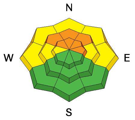
LIKELIHOOD
 LIKELY
UNLIKELY
SIZE
 LARGE
SMALL
TREND
 INCREASING DANGER
SAME
DECREASING DANGER
|
|
description
Dangerous human triggered avalanches failing in old weak faceted snow or in the basal layers of the existing snow pack are possible on slopes with poor snow structure, especially in drifted upper elevation terrain. New snow accumulating in the next couple days is likely to reactivate the buried weak layers, and persistent slab avalanches will once again top the danger priority list. I've recently found very weak faceted snow on slopes facing every direction and at all elevations, so we'll find a danger of persistent slab avalanches pretty much anywhere a significant slab layer develops. Expect dangerous conditions to develop by this afternoon in some areas.. Audible collapsing or whoompfing is a significant red flag indicating serious persistent slab avalanche potential. As today's new snow piles up and creates a slab layer, It will become possible to trigger avalanches remotely, from a distance, or worse, from below.
|
| type | aspect/elevation | characteristics |
|---|

|

|
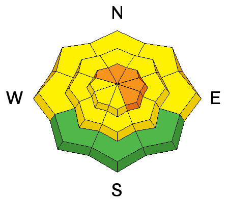
LIKELIHOOD
 LIKELY
UNLIKELY
SIZE
 LARGE
SMALL
TREND
INCREASING DANGER
SAME
DECREASING DANGER
|
|
description
Today's new snow may not bond so well to the crusty and frosty old snow surface, or soft slabs may fail on density differences or interfaces within the new snow. Triggered sluffs and soft slabs involving the fresh snow are likely in steep terrain with significant deposits of new snow, and natural avalanches will probably become possible later in the afternoon. You don't want to be caught in even a small avalanche, because you might be dragged through rocks or down trees on the slope below, and you should avoid traveling below steep slopes, especially during periods of particularly heavy snowfall when natural avalanches will be the most likely.
|
| type | aspect/elevation | characteristics |
|---|

|
|
LIKELIHOOD
LIKELY
UNLIKELY
SIZE
 LARGE
SMALL
TREND
INCREASING DANGER
SAME
DECREASING DANGER
|
|
description
Heightened wind slab avalanche conditions already exist in exposed upper elevation terrain, and conditions are likely to become rather dangerous during the day as more snow accumulates and is drifted by increasingly strong west winds. Triggered wind slab avalanches will become likely on steep slopes with recent deposits of drifted snow. Wind slabs generally form on the lee side of exposed ridge lines, but can also form on any slope aspect, especially in and around terrain features like gullies, scoops, sub-ridges, rock outcroppings, and cliff bands. Avoid steep slopes with recent wind deposits, which are often smooth, rounded and chalky looking, and can sound hollow or drum-like. It is possible that a smaller wind slab avalanche could step down into weak old snow, producing a larger more dangerous avalanche. |
 |
weather We'll see full on weather in the mountains today, intensifying west winds and heavy snowfall, with stronger winds and 6 to 10 inches of accumulation forecast by this evening. Expect 8500' high temperatures around 25 degrees this morning, but dropping into the teens this afternoon. Snowfall will resume tonight and increase again tomorrow, with westerly winds remaining in the strong category. Stormy weather should continue through the coming weekend, with another strong frontal passage, with heavy snowfall and strong wind Saturday night and into Sunday. Check out our one stop weather page........HERE |
| general announcements Utah Avalanche Center mobile app - Get your advisory on your iPhone along with great navigation and rescue tools. Discount lift tickets are now available at Backcountry.com - Thanks to Ski Utah and the Utah Resorts, including Beaver Mountain. All proceeds go towards paying for Utah Avalanche Center avalanche and mountain weather advisories. -The Utah Avalanche Center along with the Montana State University Ski Tracks project combines GPS technology with detailed logbook surveys completed by participants to help us understand how and why decisions are made in the winter backcountry. Participants will use a free smartphone app to record and send us their ski routes then, they will complete a simple online survey telling us some of the features of their tour. For more information visit: www.montana.edu/snowscience/tracks Benefit the Utah Avalanche Center when you shop from Backcountry.com or REI: Click this link for Backcountry.com or this link to REI, shop, and they will donate a percent of your purchase price to the UAC. Both offer free shipping (with some conditions) so this costs you nothing! Benefit the Utah Avalanche Center when you buy or sell on ebay - set the Utah Avalanche Center as a favorite non-profit in your ebay account here and click on ebay gives when you buy or sell. You can choose to have your seller fees donated to the UAC, which doesn't cost you a penny. Remember your information can save lives. If you see anything we should know about, please participate in the creation of our own community avalanche advisory by submitting snow and avalanche conditions. You can also call us at 801-524-5304 or 800-662-4140, email by clicking HERE, or include #utavy in your tweet or Instagram. Follow us at UAClogan on Twitter I'll issue these advisories on Monday, Wednesday, Friday, and Saturday mornings. This advisory is produced by the U.S.D.A. Forest Service, which is solely responsible for its content. It describes only general avalanche conditions and local variations always exist. |


_1.jpg)